
Yellow River (North Central Wisconsin)
This is a pleasant but overlooked tributary to the Chippewa River located just east of Chippewa Falls.
Trip Reports
Hwy O to Riverview Park
Date Paddled: June 2nd, 2024
Distance: 4.8 miles
Time: Expect 2 hours
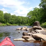
This was a fun paddle with light rapids, attractive boulder gardens and dense wooded banks. The Yellow can get shallow, so you do want to carefully time when you kayak it.
Read More...Hwy XX to Hwy K
Date Paddled: June 6th, 2026
Distance: 5.3 miles
Time: Expect 2-3 hours
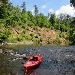
East of Chippewa Falls, the final leg of the Yellow River offers a peaceful journey through shifting landscapes. After winding past charming gravel bars and two large sand banks in a quiet bottomland setting, the river's final half-mile cuts directly through Precambrian granite bedrock, revealing a scenic series of attractive boulders and exposed bedrock.
Read More...Overview Map
Detailed Overview
Click here to see an overview map of the Yellow River.
- Upstream from Yellow River Road: The river splinters and may be less kayak-friendly, but I suspect there are viable sections for determined paddlers.
- Yellow River Road to FR 575: 7.1 miles. Technically this is the North Fork. Rick Kark describes this as having lovely surroundings, being shallow, having a number of rocks, and two sets of Class I rapids.
- FR 575 to Hwy M: 3.8 miles. I don't know much about this leg. It seems to start wooded and ends in a marsh.
- Hwy M to Diamond Drive Ramp: 1.4 miles. The north end of Chequamegon Waters Flowage.
- Diamond Drive Ramp to Miller Dam: 2.7 miles. The western end of Chequamegon Waters Flowage.
- Miller Dam to Beaver Creek Road: 1.1 miles. Attractive wooded section with light rapids, and rocks.
- Beaver Creek Road to Gilman Scout Park: 7.4 miles. Some light rapids and rocks, but not as many as the previous stretch. Still very wooded.
- Gilman Scout Park to Gilman Public Park: 0.3 miles. Short stretch between the Gilman Parks. Highlights include several scenic bridges.
- Gilman Public Park to Polley Lane: 4.2 miles. One of the best stretches on the river with some fun Class I-II rapids including "Oxbow Rapids". There should be a few small cliffs on this leg as well.
- Polley Lane to River Road: 3.0 miles. A pleasant leg with a few potential outcrops.
- River Road to Hwy S/H: 1.8 miles. Good stretch with more woods, light riffles, and rocks. But maybe not as good as the previous two legs.
- Hwy S/H to Hwy S: 1.5 miles. Very shallow rocky stretch by Hwy S. (Streetview Image)
- Hwy S to 350th Street: 2.3 miles. Rick Kark was disappointed with this leg and thought it was a bit monotonous and lacking in rapids.
- 350th Street to Hwy G: 3.0 miles. Rick Kark was disappointed with this leg and thought it was a bit monotonous and lacking in rapids.
- Hwy G to 327th Street Access: 3.1 miles. Probably an OK stretch...but be warned this leg could have several serious logjams.
- 327th Street Access to Patty's Park: 3.4 miles. Likely a good leg with a few nice boulder gardens.
- Patty's Park to 130th Ave: 2.1 miles. A good prospect with a number of shallow light rapids. There appears to be a scenic boulder garden and maybe a Class II chute above 130th Ave. (Streetview Image)
- 130th Ave to Hwy D: 2.3 miles. A very good prospect with likely some cliffs, boulder gardens and rapids. There may be a significant Class II ledge located downstream from 130th Ave.
- Hwy D to Hwy O: 5.5 miles. A good prospect with some nice cliffs. (Streetview Image)
- Hwy O to Riverview Park: 4.8 miles. A great trip with some nice boulder gardens, fun Class I+ rapids, pleasant wooded scenery, and small outcrops. There is a bit of flowage paddling near the end of this trip.
- Cadott Dam to Hwy XX: 4.4 miles. I don't know much about this leg, but looking at satellite maps, it looks like a generic bottomland paddle with a few minor boulder fields and one nice sandbank. The boulder field and rapids below the Main Street bridge are likely the trip highlight.
- Hwy XX to Hwy K: 5.3 miles. Very nice stretch with a mix of bottomlands, minor rapids, gravel bars, and several scenic sandbanks. The highlight is the final half-mile which features attractive granite boulders and exposed bedrock.
- Hwy K to Lake Wissota Landing - 196th Street: 0.8 miles. A possible short add-on stretch through Lake Wissota's Moon Bay to reach a public ramp. I think this would be a mediocre lake paddle. Note parking at the 196th Street ramp may be difficult.
- Lake Wissota Landing - 196th Street to Lake Wissota - State Park Ramp: 0.8 miles. Another possible short add-on stretch through Lake Wissota's Moon Bay to reach a public ramp. I think this would also be a mediocre lake paddle. The State Park Landing is very good, but it would necessitate an unpleasant shuttle because it's at the end of a long dead-end road.
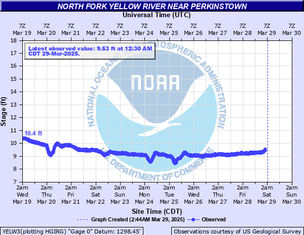
Nearby Guages
Videos
How did your trip turn out? Questions or comments? Feel free to leave your feedback.
SUBMIT COMMENT!
Be notified when future paddle reviews go live by subscribing!
