Platte River

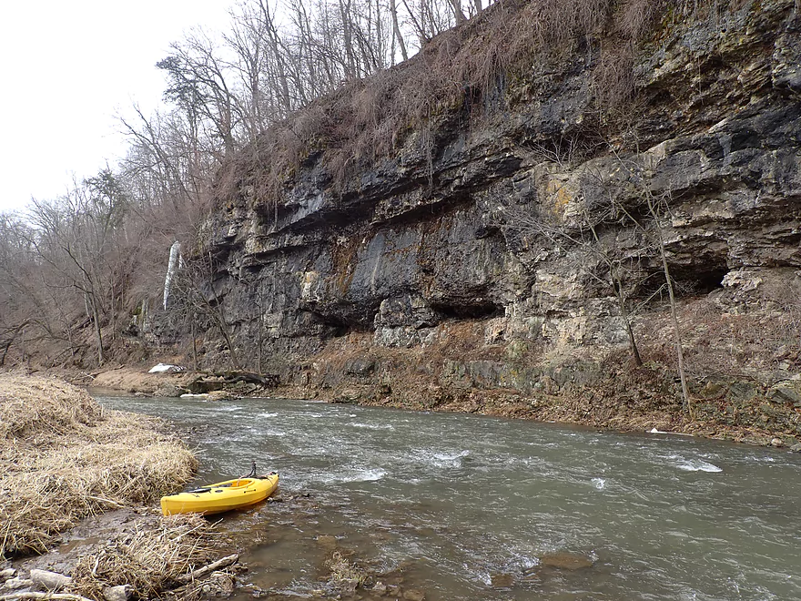
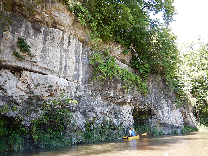
While not as scenic as neighboring Grant River, this is still one of the elite paddling rivers in Southern Wisconsin.  Highlights includes limestone boulders, fun rapids, and scenic outcrops.

Trip Reports

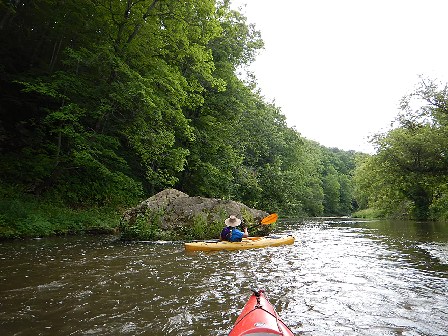
Coon Hollow Road to Hwy A


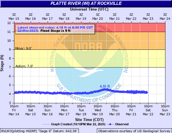
Date Paddled: April 2nd, 2023
Distance: 3.8 miles
Time: Expect 2 hours

This Upper Platte River leg isn't perfect.  It does need high water levels to be runnable and the shoreline erosion is unsightly.  But, the rapids and limestone cliffs are fantastic.

Read More...

Hwy A to Airport Road


Date Paddled: July 9th, 2016
Distance: 6.3 Miles
Time: 4 hours 32 minutes (3 hours is more typical)

An upstream section of the Platte with fantastic limestone outcrops and fun riffles.  This section however is negatively impacted by grazing and does run dry in late summer though.

Read More...

Airport Road Bridge to Platte Road bridge


Date Paddled: August 4th, 2013
Distance: 5 Miles
Time: 3.5 Hours

Located in the SW corner of the state, the Platte is a very nice river often overlooked by paddlers.  Unlike its more popular neighbor, the Grant, it has little in the way of rock outcroppings (although it has a few).  It also suffers somewhat from poor agricultural use and barbed wires running across the river. […]

Read More...

Platte Road to Big Platte Road


Date Paddled: June 14th, 2015
Distance: 5.1 Miles
Time: 4 hours (2.5 hours would be more typical)

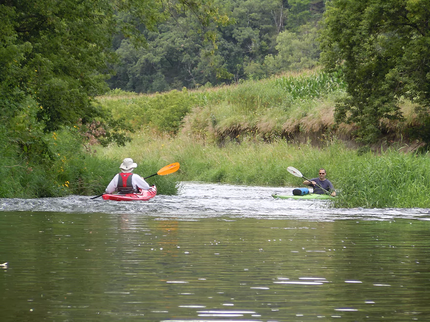
A fine southwestern Wisconsin paddle with many fun but safe rapids.  This is mostly a rural farm paddle, but is still scenic with great views of the driftless hills.

Read More...

Overview Map

Detailed Overview

Nearby Guages

Videos

View in full screen and 1080p for best video quality!

Comments

Jul 11th, 2020 - Aaron from Dell Creek
Yikes...some of those wires are very difficult to see. These fences shouldn't exist on the river...and at a minimum should be well taped/marked so people can see them. That's horrific. I have marked that Kingsford Road wire as a hazard on both my maps. Despite that I'm super enthused to do this section...plus the preceding which should also have nice outcrops. I appreciate tips about the parking situation for Coon Hollow which I didn't know about.
Jul 11th, 2020 - Jon from Starkweather Creek
We paddled from Coon Hollow Rd. to Airport/Ellenboro Rd. on 10July2020. The Rockville gauge was about 300 CFS at 5 ft., a fun level with the right boats and skills. We got hung up a few times, but didn't have to walk our boats. It was a scenic paddle on a gorgeous day, but there's one hard-to-spot wire below Kingsford Rd., and the put-in at Coon Hollow is a bit tricky. Just downstream from the Coon Hollow Rd. bridge, there were two strands of barbed wire, one just above the water, and another about a foot above it. (See link to album of wires photos below). The only good option appeared to be to slide our boats under the electric fence and launch downstream of the wires. I drove a bit downstream to scout other options, and noticed someone sitting on the porch of a house nearby. Not wanting to trespass, I asked her if she was the owner of the fenced-off area, but she wasn't. She said that paddlers put-in downstream of the wire frequently, and that 7 or 8 Amish folks with canoes had done so about a week ago. She helpfully noted that the person who mows the park area just downstream from the bridge prefers that people park on the mowed shoulder on the upstream side of Coon Hollow. I was able to spot and most of the electric fences and sneak under them, but my buddy sitting upright in a canoe used a PVC "y-er" to lift the wires. Just downstream from the Kingsford Rd. bridge I was startled to feel a wire across my neck. I turned my head and leaned back, and the wire slid up and off my face. I pulled over just downstream of the wire to warn my friend. Despite my shouting, he couldn't see the wire until too late, so did a wet exit from his canoe, then hauled his water-filled boat to shore. We were both fine, largely because I was wearing a neck gaiter and a Kool-Tie around my neck, and had the cape of my sunshade ball cap tucked under them. The wire scraped fabric, not flesh, and I was drifting rather than paddling. However, a paddler sitting higher in a boat with no neck or face protection could get injured. The current speeds up near the wire. Here's a link to photos of the wires at Coon Hollow, Kingsford, and an example of an easy-to-spot electric tape upstream of Hwy 81: https://photos.app.goo.gl/JDsrj3aShaP49GxC6 I would not recommend that beginners paddle the stretch below the Kingsford Rd. bridge without scouting it first. Scotty, (the DriftlessKayaker) posted this June 12, 2020 video of Coon Hollow to Ellenboro: https://youtu.be/u_GR-ukTTBM (There were no wires at Kingsford on June 12.) On a brighter note, here's an album of scenic photos/videos: https://photos.app.goo.gl/2jrG4VFPZJBVGuBcA
Sep 2nd, 2019 - Aaron from Dell Creek
Lot of good information on the logjams, water levels and fences that will help other paddlers. Appreciated as always Eric.
Sep 2nd, 2019 - Eric G from Wingra Creek
I did this section on 9/2/19, levels were great 140 cfs and 4.08 ft, the rapids/riffles were perfect, just a good current, never really pushy. A few shallow spots where we scared or bumped along the bottom, but never had to take the boat for a walk. There was one portage, right at the Quarry road access, due to two trees blocking the creek from shore to shore, There is a wide gravel bar there so it is a very easy portage. Also there are still two places where wire/cable cross the river, they are actually fairly dangerous as they are hard to see and only a foot or so above the water. They are not barbed wire or electric but, and are not hard to get under if you see them in time. Neither was marked, but I was able to put strips of duct tape on the first one. They are both in the last part of the trip, just after a nice rock outcropping on river right and the takeout on Big Platte. Wildlife on the trip was great, we saw a lama in the water (much more fun than a cow) a badger, a swimming chipmunk (ground squirrel?) and an 8 point velvet buck who just froze and let us drift past 15 ft away. along with numerous ducks, geese, herons, and cows
Jul 2nd, 2018 - Aaron from Dell Creek
I appreciate the update! The Platte really got beat up by floods earlier this year and it is good to hear that it is still navigable.
Jul 2nd, 2018 - Jon from Starkweather
Paddled from Platte Rd. to a bend on Big Platte Rd. near Blakely Branch just off Quarry Rd. on July 1, 2018. Next time we'll likely go all the way to the Big Platte Rd. bridge, despite the muddy takeout. Nice stone steps and a carpeted kayak ramp at this takeout, however. USGS gauge was at about 4.17 ft., and 200 CFS, so very little scraping. Lots of wild parsnip by the roadside at the put-in, so we had to take care not to brush against it while carrying boats down. No wire, barbed or otherwise remains. The front end of the old car has now washed into the river. Two heavy rains within the past two weeks caused the river to crest at 800 and 600 CFS, so lots of debris 2 ft. or more above the water. Cattle in the river were cows and steers (no bulls), and we had plenty of room to drift past. Saw one bald eagle, great blue herons, turkey vultures, kingfishers. Great paddle.
Jul 25th, 2017 - admin
Thanks Ken for the question. Fences that block navigation are not allowed. In fact the DNR has cracked down on these in the past (like on the Fever River). The current DNR however maybe apathetic to this issue. You can always contact them and ask. If this is a safety issue, they may be more apt to act. The cows...that might be a grey area...as is letting a bull wonder to close to a public waterway. I mean it wouldn't be permissible to allow a bull to wonder near a public playground, so perhaps the same logic protects paddlers. BTW, if you ever want to share information on the Rush River, I would be happy to post it.
Jul 25th, 2017 - Ken Hollern from Rush River
Hi, This may be off subject, but I noticed your references of cows and fences crossing the river. Do you have any insight on the legality of this? If the river is technically public land, can cattle and fences have free access? I live right next to the Rush River in Western Wisconsin, which is heavily used for kayaking and fishing. A local farmer has his land adjacent to a long stretch of river. He freely lets his cows have access and has strung live electric fence across river. However, the biggest concern is he has put a bull in with the cows creating a very dangerous situation for unwitting river users.

How did your trip turn out? Questions or comments? Feel free to leave your feedback.

SUBMIT COMMENT!
Be notified when future paddle reviews go live by subscribing!
Contact WisconsinRiverTrips.com