
New Richmond put-in is posh
Evidence of surgical cuts to keep the river open
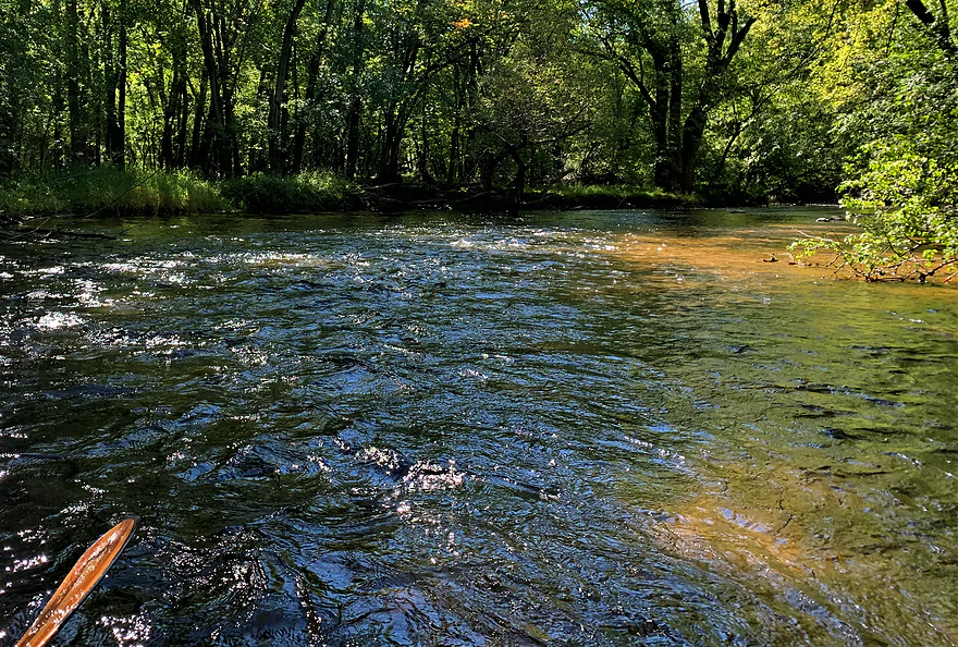
Riffles, riffles everywhere on the Willow
Always good to look where you’ve just been
At first glance, looks like a cluster — but there’s your opening on the left
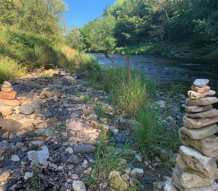
Fun cairn garden near the end of the trip
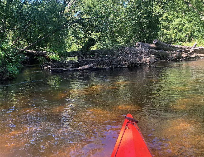
Easy portage around this mess
Never-before-seen notice on a Wisconsin river
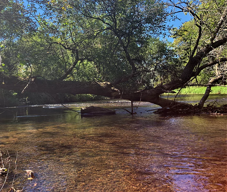
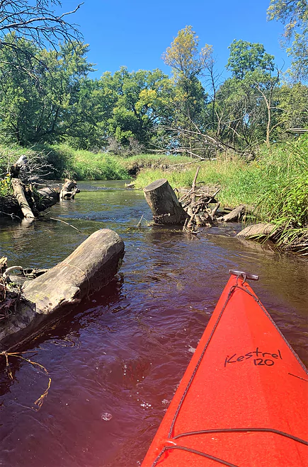
Typical Willow R deadfall — easy to navigate
Easy Class II near Willow R State Park
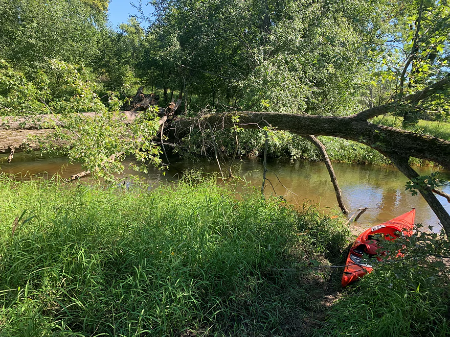
Eddy out of the channel into this backwater at take-out
Willow River

I want to avoid the “hidden gem” cliché here, but I won’t, in singing the praises of this delightful stream with so much to offer, on the exurban edge of the Twin Cities in western Wisconsin. Clear, cold water, very limited development, sandy or gravelly bottom, manageable deadfalls and stimulating riffles – and, for dessert, Class II whitewater.
There’s the sheer surprise and delight of a sweet paddling destination so close to the Twin Cities. (The hegemony of “the Cities” can be sensed here in the traffic volume and rural subdivisions.) There’s the very manageable whitewater run at the end of the trip, and if that’s not on your menu, the Willow, from New Richmond to just above the whitewater section at the end, is appealing and easy.
My “menu” for the Willow has four items, or distinct trips.
1). If your time is tight, put in at New Richmond and take out at 100th St. for a two-hour run.
2). Start your trip at 100th St. and bail out at the state park access off County Road E to avoid the rapids.
3). Do the entire run, from New Richmond to the take-out at the junction of St. Croix County Roads A and I (state park parking lot there). The complete trip could be easily accomplished in a day under the right conditions (and maybe some good luck). That’s what I did; it took me about 4.5 hours.
4). Do just the whitewater run. It would take no more than a half hour, but would stimulate a day’s dose of adrenalin. Put in at the state park river access off County Road E and paddle down to the County A-I junction (state park parking lot).
With countless easy-to-manage riffles, and Class II whitewater toward the end of the run, pay attention to the water levels for an enjoyable excursion on the Willow. There’s a U.S. Geological Survey flow gauge on the Willow River at Burkhardt, WI, near the take-out. That gauge read 180 cfs and 18.5 feet on the day of my excursion. Average flow at this gauge is 150 cfs. Flow was adequate if a bit low for my purposes. Don’t run it if the flow is below 125 cfs and 17 feet.
Another reliable source of flow information is American Whitewater’s website, which reports hourly flow readings.
The Willow River is probably best known in the whitewater community because of the fun and accessible 2-mile stretch of whitewater near Willow River State Park. (There’s a waterfall and gorge in the park that must be avoided.) Beyond that, this river seems to get little attention.
Those two intrepid chroniclers of small Wisconsin rivers, Rick Kark and Frank Piraino, dabbled on different sections of the Willow. In the mid-1990s, Piraino encountered the upper section that I ran but found it “plagued with deadfalls.” There are deadfalls still, but it’s been cured of the plague. For his part, Kark traveled in 1982 from the dam within the state park to a road crossing 3 miles downstream.
At this point, it’s worth pointing out an odd discrepancy in Google’s renditions of this river. In Google Maps, there is a long, wide “Mounds Pond” depicted where the whitewater section is now. Two dams were removed in this area when Northern States Power Co. sold the land to Wisconsin’s Dept. of Natural Resources in the 1960s to create the park. Removal of the Mounds Dam in 1998 revealed the fine rapids that had been submerged under the pond. On the other hand, Google Earth, even if it has the words “Mounds Pond” stamped on its aerial photo, shows current reality: you can see that vegetation hasn’t completely filled out the old mill pond bottom; the rapids, captured by satellite photography, shimmer in the sun.
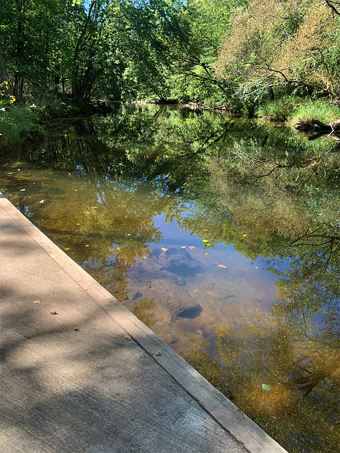
My trip started in the city of New Richmond, at Sanger Nature Center, downstream left just below the Wisconsin Hwy. 64 bridge. I took out at a parking area for Willow River State Park, at the junction of Pierce County Roads A and I. That is the longest of the four possible paddling trips on this river. The shuttle for any of the four trips, by car or bike, is straightforward: County Road A, whether by bike or car, is the shuttle pipeline for all versions of this trip. (Total shuttle miles by bike, between the take-out at County Roads A and I to the uppermost put-in at New Richmond, is 8.5 miles.)
I’d never heard of the Willow River Water Trail until seeing a sign for it at 100th St. bridge that features a well-developed put-in/take-out. I suspect its members or promoters are the river angels cutting some deadfall to keep the river open. Unlike anything else I’ve read about the Willow, the Water Trail promotes the river upstream of the big impoundment at New Richmond. They show the river to be navigable from County Road T, east of New Richmond. Here’s their site: https://www.
At 4.5 hours at my admittedly rapid pace, the full 12.5 miles may be too much for many paddlers to go from New Richmond (where there’s a posh concrete-and-timber put-in) to the take-out at the County A and I junction. The four trip options cited above all assume using that take-out at the state park parking lot (called the Willowby parking lot on the state park map).
Immediately upon putting in at New Richmond, the Willow’s character, for the next 5-6 miles to 100th St., makes itself known. The water is clear and cold, current is steady, substrate is rocky or sandy; with very little development and no nearby highway noise (yet), things feel delightfully remote. Riffles alternate with deadfalls, almost all of them navigable at first; there is evidence local river angels cut some openings, done to my liking: they are surgical in their cuts, making navigating deadfalls fun yet safe. Silver maple forests alternate with farmland, but you won’t see very much of the latter.
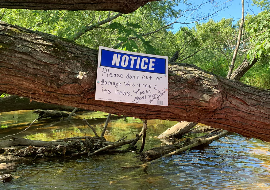
About 45 minutes into the trip, the river widens and flattens, then becomes beguiling, with more sharp turns and a handful of challenging deadfalls. One, comprised of two huge downed silver maples, should be portaged on river right. Then comes something I’ve never seen in a Wisconsin river: a sign nailed to a downed tree that says, “Notice: Please don’t damage this tree or its limbs.” Whoever put up that sign also provided a sign to indicate a portage (right).
Take the portage should you paddle this section of the Willow, but to my mind this is questionably legal. The tree may have fallen from private land, but the river itself is a public waterway, under Wisconsin’s public trust provisions, and you can’t block a navigable waterway. The person did provide a portage so the river is not technically blocked, but it seems silly to not allow cutting a few limbs to allow paddlers passage. The tree is doomed anyway.
That “forbidden deadfall” was one of only three that I had to leave my boat to portage or climb over on the way to 100th St. The rest made for practicing slow-motion precision navigation.
The 100th St. bridge is about two hours from New Richmond. Here you could take out (upstream right, very nice access), or you could start your trip here. It is roughly the halfway point, but the lower half includes the whitewater stretch, which could be avoided if you want to. (More on that in a bit.)
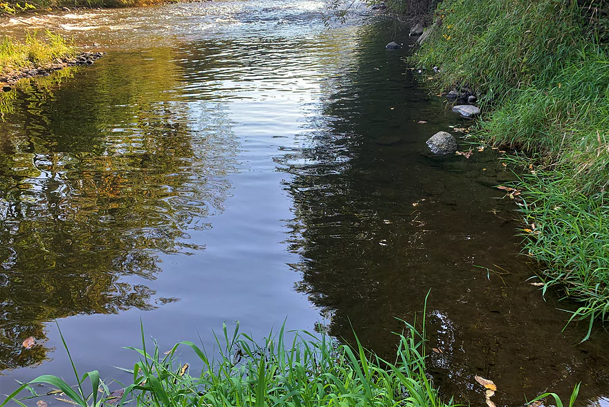
From this point, the river widens and flattens again, and it appears to have been, unfortunately, sterilized of trees by the local paddling community – no more deadfalls. Riffles return pretty steadily from 100th St. to where the river passes under County Road A. You’ll swear you’re in northern Wisconsin at this stretch of the Willow, with white pines standing tall atop dolomite bluffs.
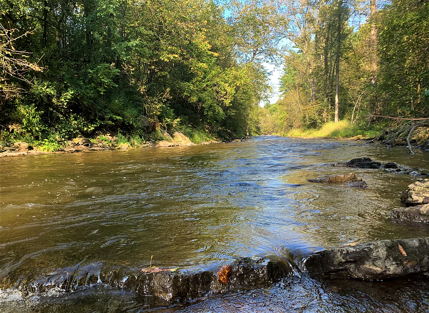
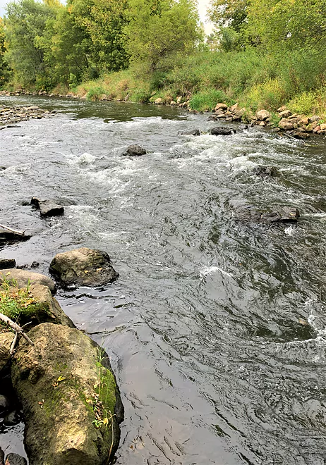
Beyond the County Road A bridge, things get interesting. There’s a nice piece of Class I water, then you’ll pass beneath the County Road E bridge. Immediately thereafter, the Class II rapids begin. I was careless and nonchalant entering the first set of rapids and quickly dumped. I was now alerted to the series of rocky runs and drops that make this section a whitewater destination. American Whitewater’s web page for the Willow describes these rapids as “shallow, not pushy at all,” and routes can be found “through easy rapids.”
I agree wholeheartedly with this assessment. In summer, this would be a perfect training rapid for paddlers inexperienced with whitewater but game to try it. If you are not inclined to try it, I suggest exiting the river on river-right, about 100 yards below the County E bridge, which takes you to the state park access point (called Mound parking lot on the state park map). From that take-out, it’s about a 300-yard hike/drag-of-boat back to your car. (Don’t get out at County E – terrible access to the road from the bridge.)
These mild rapids can easily be scouted from the state park parking lot off County E. I failed to do that and had a delightful and wet surprise.
After the first two sets of rapids, there is a long stretch of easily navigable Class I riffles, with fun wave trains to bob over. This continues pretty much to the take-out, your signal for which is the second of two County Road A bridges. Be careful taking out here, as the river is pushy: best spot is river right, downstream from the bridge. Eddy out into a small inlet. A path of 50 yards takes you to the parking lot.
Do get out here: if you don’t, you’re headed to a small cataract known as Willow Falls about a river mile downstream.
There may even be a fifth trip on the Willow River, upstream from the city of New Richmond, which the Willow River Water Trail Initiative claims is navigable. I’m guessing generous water levels would be necessary for that piece.
Thanks for the review Denny! This is a trip I almost did a month back but had to cancel at the last moment.
Some other interesting tidbits readers may be interested in.
- Willow Kayaks is a rental and shuttle service on the Willow River.
- WillowRiverWaterTrail.org as mentioned by Denny is a terrific site that provides information about the Willow River. They have a great map worth checking out.
- Willow Falls is too rough for most kayakers to run, but a state park trail does provide a scenic vista of the waterfall which is worth checking out.
WisconsinRiverTrips.com is always very appreciative of guest reviews, and if you the reader is ever interested in submitting one, you can use this online form.
- Hwy K to Betterly Waterfowl Area: 4.3 miles. Some obstructions included and likely ~4 major logjams that will require portaging.
- Betterly Waterfowl Area to Mary Park: 5.1 miles. This stretch has some serious logjams and is not recommended.
- Mary Park to Hwy 65 River Access: 0.7 miles. A simple lake paddle.
- Hwy 65 River Access to Doughboy Trail: 825′. Here you need to portage a dam (north bank). The re-entry point is by some rapids.
- Doughboy Trail to Sather Nature Center/Hwy 64: 1.9 miles. An easy relaxing route. I believe this used to have logjams, but I suspect they’ve been all cleared out recently.
- Sather Nature Center/Hwy 64 to Junction of Roads A and I: 13.3 miles.
- Sather Nature Center/Hwy 64 to 100th St: 6.1 miles. Narrow with some obstructions including three logjams that require portaging. Some minor rapids. A good stretch.
- 100th St to 140th Ave: 2.1 miles. River widens and has steady riffles. Obstructions should no longer be an issue.
- 140th Ave to Hwy A: 2.1 miles. A good stretch with more steady riffles.
- Hwy A to Hwy E Pulloff: 1.4 miles. Includes a nice stretch of Class 1 rapids.
- Hwy E Pulloff to Hwy A/I: 1.7 miles. A long stretch of Class 1 rapids and one Class 2.
- Hwy A/I to Burkhardt Trail: 0.9 miles. More fun rapids. The take-out is poorly marked and requires a 1000′ hike on a trail back to the parking lot. Do not miss this, as there are dangerous rapids downstream from here with no easy way out of the gorge.
- Burkhardt Trail to Willow Falls: 1.0 miles. Includes very strong/dangerous rapids including the scenic waterfall Willow Falls at the end. Not suitable for kayaking and there isn’t a good way to get out of the gorge.
- Willow Falls to Little Falls Lake Launch: 1.7 miles. Starts with some decent rapids and then transitions into an open, lazy stretch with a few minor riffles. This used to be Little Falls Lake, but a dam was recently removed. Paddlers used to go upstream to Willow Falls and back but this may no longer be viable. Willow Falls is a tricky put-in as you have to hike down a third of a mile trail to reach the river. Little Falls Lake Launch may no longer be an easy river access because of the downstream draw-down.
- Little Falls Lake Launch to New Willow River Dam Remnants: 0.6 miles. An open paddle over the remnants of a former flowage. The dam was partly closed during the removal. I’m not sure it’s 100% open to the public yet.
- New Willow River Dam Remnants to Hwy 35 Boat Ramp: 4.5 miles. A very wooded stretch with some rapids of unknown strength. Some downed trees in fast current could create dangerous strainers, especially in high water.
- Access to the Mississippi just below Hwy 35 is blocked by a dam. I’m not sure it’s worth portaging.
Trip Map
Overview Map
Video
Photos Size:
Attempted to run the Betterly Waterfowl Production area to Mary park section of the river. After about and hour, maybe a mile, and 4 full blockages of the river we pulled out at the farm of a nice family that gave us a ride to our car. They informed us that there was a pretty major flood a few years ago that jammed up the river. Do not attempt this section until some cleanup is done.
Thanks for the heads up. Hopefully this warning helps other paddlers. I’ve updated the review and map.
Just a short way down from the New Richmond launch significant river blockage, 4,5 trees down blocking the route did not see access around nor did I attempt since I had my son with me. Don’t anticipate it being cleared anytime soon due to the wall of trees down from the heavy snow fall this winter. Maybe they’ll clear out for a portage to walk around it.
Thanks for the update