
Rubicon River
This is one of the smaller rivers in the state. While congested at times, it’s a neat creek with a handful of surprise rapids.
Trip Reports
Hilldale Drive to West Side Park
Date Paddled: April 6th, 2019
Distance: 3.0 miles
Time: 3 hours 20 minutes (90 minutes would be more typical)
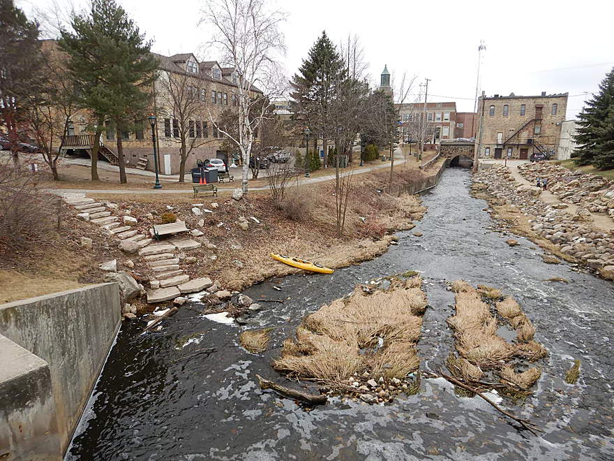
Another Ice Age paddle that turned out surprisingly well. This was mostly an urban segment through downtown Hartford with the highlights being attractive bridges, riverside architecture, light rapids and good clarity.
Read More...West Side Park to Hwy 60
Date Paddled: July 7th, 2019
Distance: 3.6 miles
Time: 3 hours 45 minutes (100 minutes would be more typical)
This was not as nice as my last Rubicon trip because of some deadfall issues, but this segment does have a lot of potential, especially in the second half where there are many light rapids.
Read More...Jefferson Rd to Hale Road
Date Paddled: May 22nd, 2021
Distance: 4.3 miles
Time: Expect 2 hours
Much of this trip was a flowage paddle...muddy, carp-infested and not super interesting. The last part below the dam though was really nice with the highlights being several small boulder gardens and light rapids.
Read More...Overview Map
Detailed Overview
- Beach at Pike Lake State Park to Hwy 60: 1.1 miles. This is a large lake. The northern shoreline along the state park boundary might be nice.
- Hwy 60 to Hilldale Drive: 0.9 miles. Maybe 7 logjams. Very congested. Hwy 60 is a poor access option and poor dam portage.
- Hilldale Drive to West Side Park: 3.0 miles.
- Hilldale Drive to Willowbrook Park: 1.7 miles. Mostly an open and simple wetgrass paddle. There are several Class 1 rapids above the railroad bridge and several strong Class 1 rapids below it. One low walk bridge will have to be portaged.
- Willowbrook Park to Post Office/Library/Dam: 0.6 miles. Mostly open flowage paddling, but some light rapids by Willowbrook Park. The park area and its bridges are quite striking.
- Dam to Jordan Park/Rural St: 0.2 miles. A very scenic urban paddle through downtown Hartford.
- Jordan Park to West Side Park: 0.5 miles. Cool section. Very narrow and rocky with several light rapids. Mostly wooded, but goes by some industry. Some snags, but I didn’t have to portage. Note in 2023 a paddler reported multiple serious jams in this stretch. Taking out at Rural Street is now recommended unless you scout the downstream leg.
- West Side Park to Hwy 60: 3.5 miles.
- West Side Park to Wacker Drive: 0.2 miles. A short section through an industrial stretch. Some deadfall to dodge.
- Wacker Drive to Liberty Ave/Sewage Plant: 1.5 miles. Starts with a wooded section with a lot of deadfall and two logjams that have to be portaged. After that the river opens up. As of 2024 this stretch has filled in with logjams. It is not recommended.
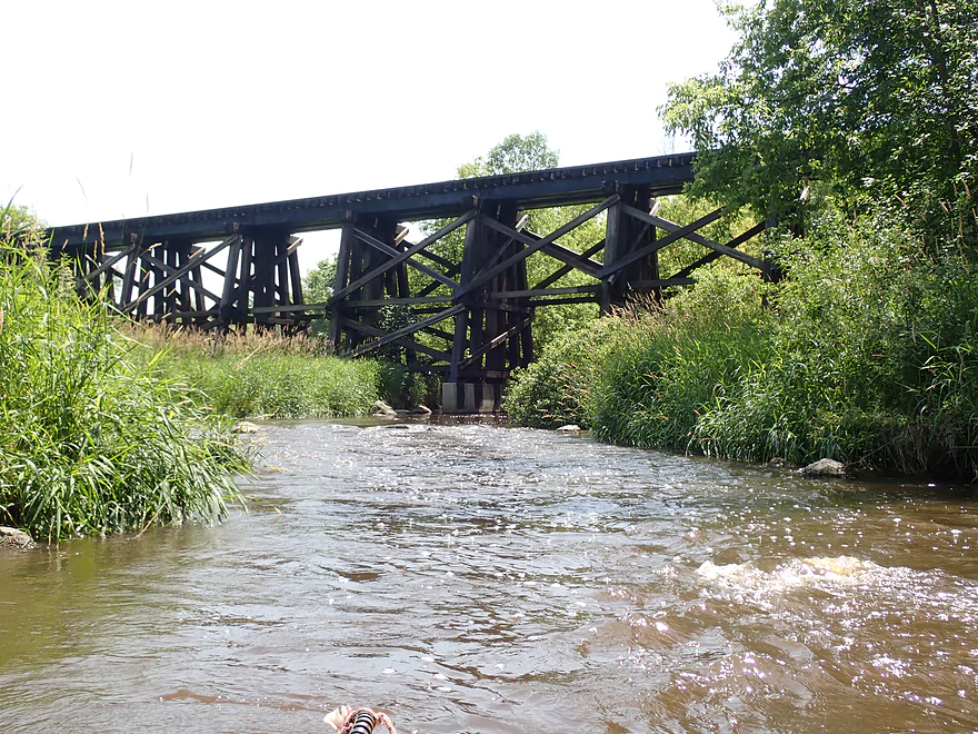
- Liberty Ave to Goodland Road: 1.3 miles. A rocky section with multiple sets of rapids.
- Goodland Road to Hwy 60: 0.5 miles. Neat section with fast current.
- Hwy 60 to Pond Road: 1.9 miles. Maybe 7 logjams mostly in the first half. The second half of this leg looks really scenic though. Parking at Pond Road looks steep and difficult.
- Pond Road to Saylesville Road: 1.4 miles. Good prospect with a lot of rocks. Maybe one logjam.
- Saylesville Road to Resthaven Road: 2.0 miles. Interesting prospect that is very rocky. Maybe 3-4 logjams.
- Resthaven Road to Hwy P: 2.3 miles. Maybe 4-5 logjams. Very scenic.
- Hwy P to Jefferson Road: 2.0 miles. Maybe 5 logjams.
- Jefferson Road to Hale Road: 4.4 miles.
- Jefferson Road to Woodlawn Park: 2.6 miles. Slow, muddy stretch through mostly impounded and carp infested waters. Neosho Millpond features some motorboat traffic and shoreline development.
- Woodlawn Park to Neosha Dam Fishing Access: 0.3 miles. Short leg on the flowage. Portage is a bit tricky because of a guardrail and medium busy road.
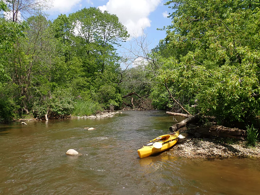
- Neosha Dam Fishing Access to Hale Road: 1.5 miles. A great stretch with some light rapids, boulder gardens, and nice woods. 2024 update...After the dam, there are massive white poplar trees toppled over into the river forcing two difficult portages through a hunting stand in thick brush.
- Hale Road to Hwy EE: 5.6 miles. Maybe over 30 logjams.
- Hwy EE to Mouth on Rock River: 3.5 miles. Reviewed by Rick Kark (critically).
- Hwy EE to Pike Road Pull-off/Creek Bridge: 1.5 miles. Somewhat open, but still ~4 logjams.
- Pike Road to Rock River: 2.0 miles. Floodbottom forest. Maybe 20 logjams.
- Mouth to Elmwood Road: 0.3 miles. Short easy stretch on the Rock River.
Nearby Guages


Videos
Comments
Thanks Gregor for the update. I updated the review to include your warning.
I paddled this earlier this week on 04/30. Going from Jefferson Road to the Neosho Millpond Dam was a fun trip, and the best leg of the Rubicon IMO. I was excited for the section beyond the dam, however, there are massive white poplar trees toppled over into the river forcing two difficult portages through a hunting stand in thick brush. I would recommend taking out at the Millpond dam or doing a roundtrip from Jefferson Road unless those jams are cleared.
Thanks Gregor for the warning. I'll post an update to the review on this. 60 to Pond Road looks bad. Yes, I'm mostly using satellite images...but I'm getting a bad vibe from it and would advice avoiding it. If you do this let us know how it turns out.
Hi Aaron, I paddled this stretch last night at 42 CFS. From Wacker Dr to Liberty Avenue there are now over half a dozen log jams that seriously impede paddlers. None were easy portages due to the thickets of vegetation and steep banks. Unfortunately, now almost the entirety of the Hartford section of the Rubicon is not worth paddling and is impassable with dead ash, willows, and boxelder. It's surprising that at one point you enjoyed this trip, so I'm not sure why deadfall is no longer being managed.
The stretch from Liberty Ave to Hwy 60 saved the trip, and I really enjoyed how the current picked up. However, I wouldn't run this again at 42cfs as I dragged on the rocks a lot. There is also a newer metal pedestrian bridge right at the sweet spot of the class II rapids where the river corners and heads south that is ripe for collisions with kayaks.
I'm curious about heading south of 60 towards pond road, but not sure it's worth my effort. Are you mainly looking at Google Earth to scout log jams? I'm not sure it could be worse than the prior industrial section is now.
Thanks for the comments and the very valuable information. I'll update the review to warn other paddlers.
I tried combining both Rubicon River trips you reviewed today (04/22/23) through Hartford. The first trip for the most part (from Hilldale Dr. to N. Rural Road) was great. I really enjoyed the sections going under the bridges downtown and the rapids after putting in in front of the dam. However, I cannot recommend trying to kayak from N Rural st. through to Wacker Drive. This section is extremely overgrown with Buckthorn & Boxelder thickets, with numerous logjams. Portaging around the industrial complex was difficult given the growth of the vegetation into the stream.
Behind West Side Park was the worst strainer I have seen, a sturdy downed Willow tree at chest height completely across the water. At 63 CFS (Bark River gauge) the river was moving quickly enough and there is little time to react without capsizing or hitting this in the chest. The banks are also too steep to get out of the boat without plunging into chest deep water. Nature is reclaiming the river. I'd recommend editing the first trip details to stopping at N. Rural Road for leg 1, and then starting the second section again at Wacker Dr. Although that isn't a great portage with rocky embankments.
Thank you!
I just wanted to say that I stumbled upon this website searching for more details on the Wisconsin River/lake system in hopes to find new and great paddle drop off/pickup points and maps. I quickly realized there is nothing that tells you established rivers/channels to plan a paddling excursion (especially since it’s a newer hobby) at the drop points. And even more so none with pictures, reviews, and maps all in one place. This website is amazing and is going to make my summer planning a breeze! Great site!
How did your trip turn out? Questions or comments? Feel free to leave your feedback.
SUBMIT COMMENT!
Be notified when future paddle reviews go live by subscribing!
