
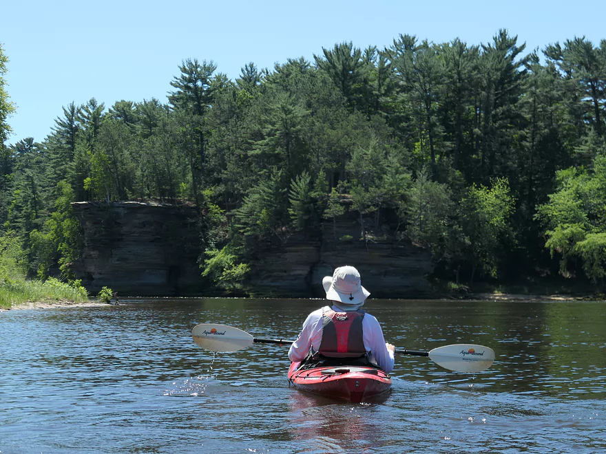
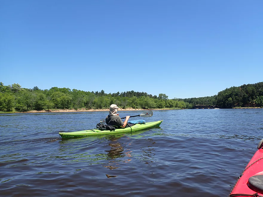
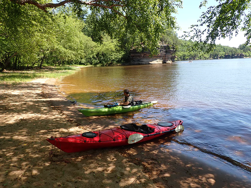
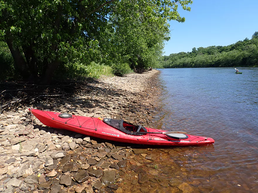
Starting the trip at the tour boat landing off Hwy 12
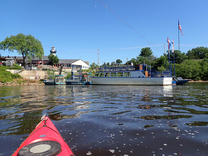
The main dock for the “Dells Boat Company”
Large amounts of foam
A jet boat gets surprisingly close to an open spillway
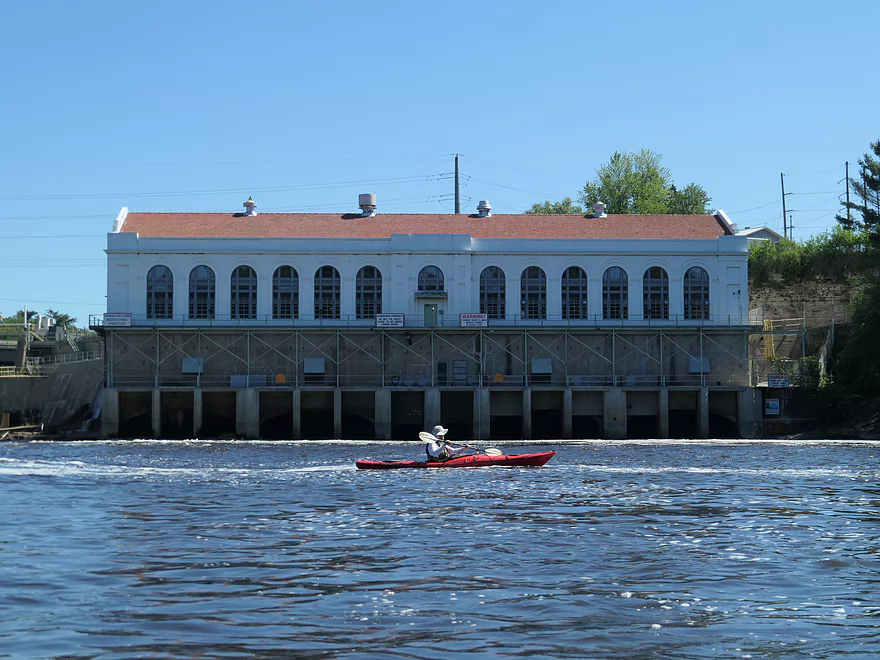
The Kilbourn Dam powerhouse
The jet boats created monster waves
Fast current in the first half mile
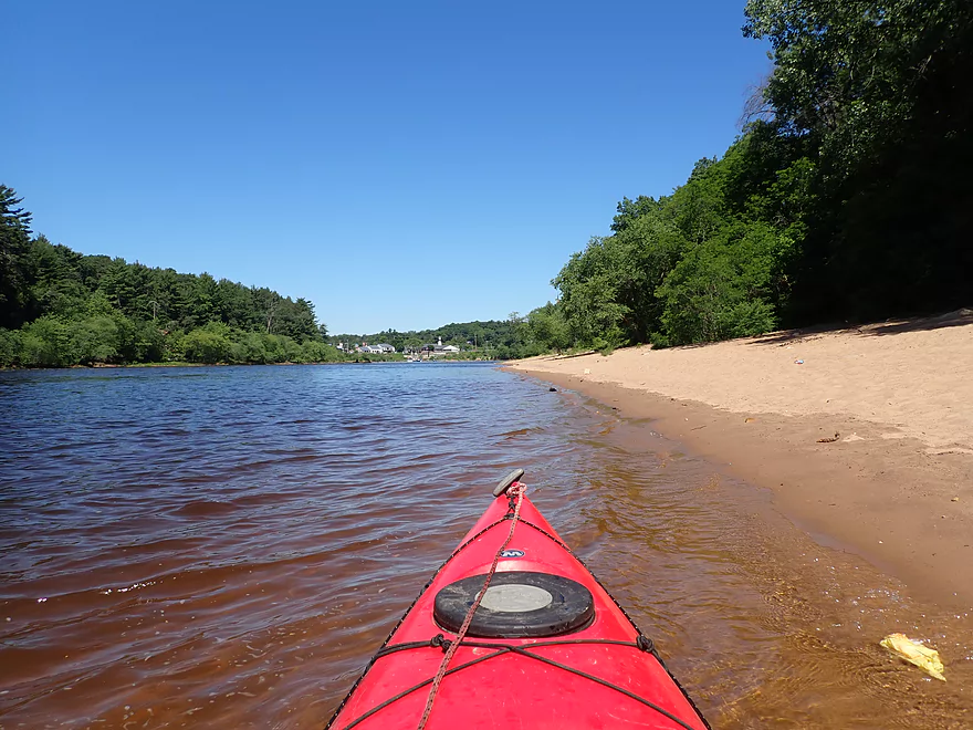
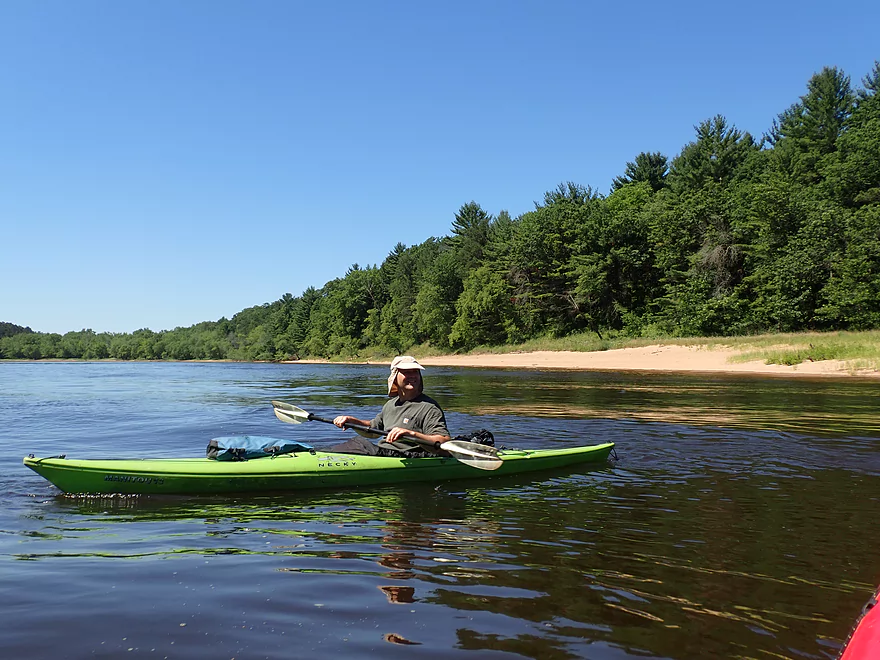
Sandy shoreline
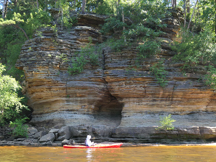
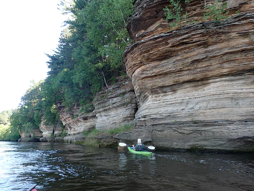
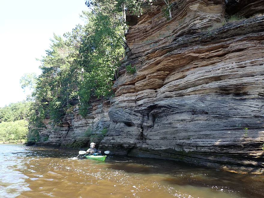
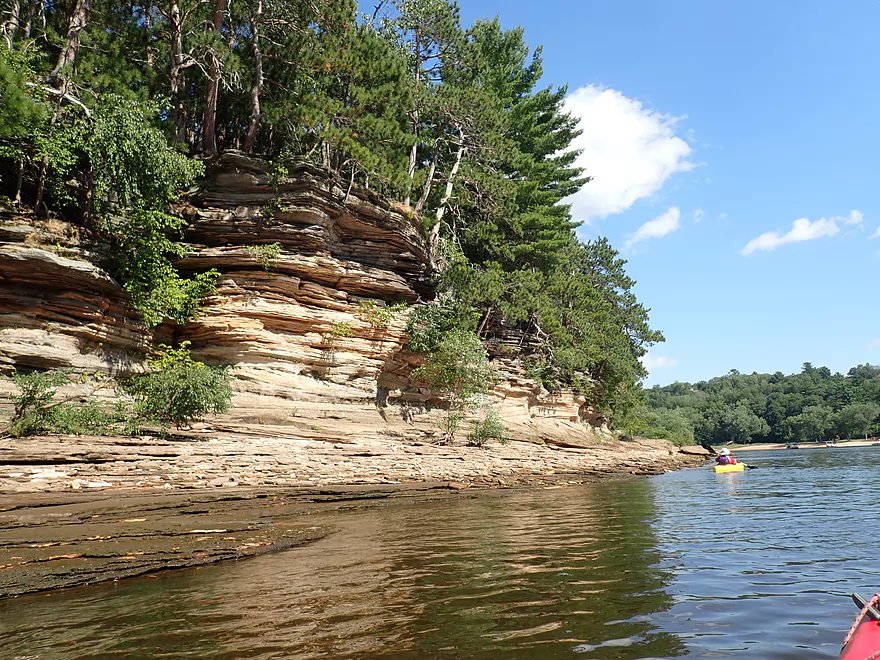
First decent outcrop
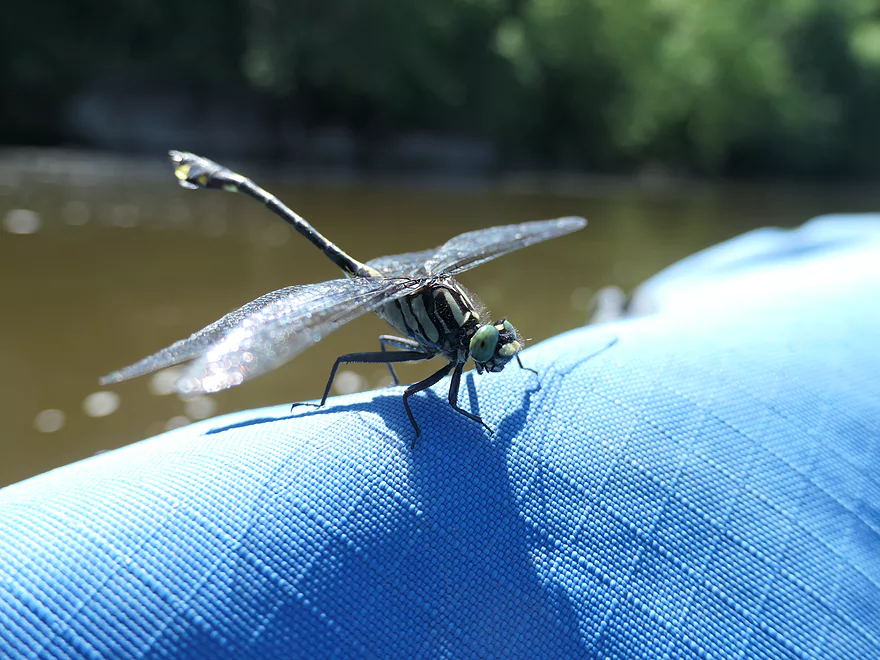
Terrific green eyes
First major outcrop
Very cool
Tour boats can’t get this close
A duck launching into the Wisconsin
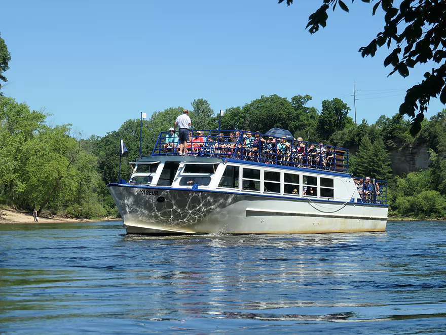
The largest boats on the Lower Dells
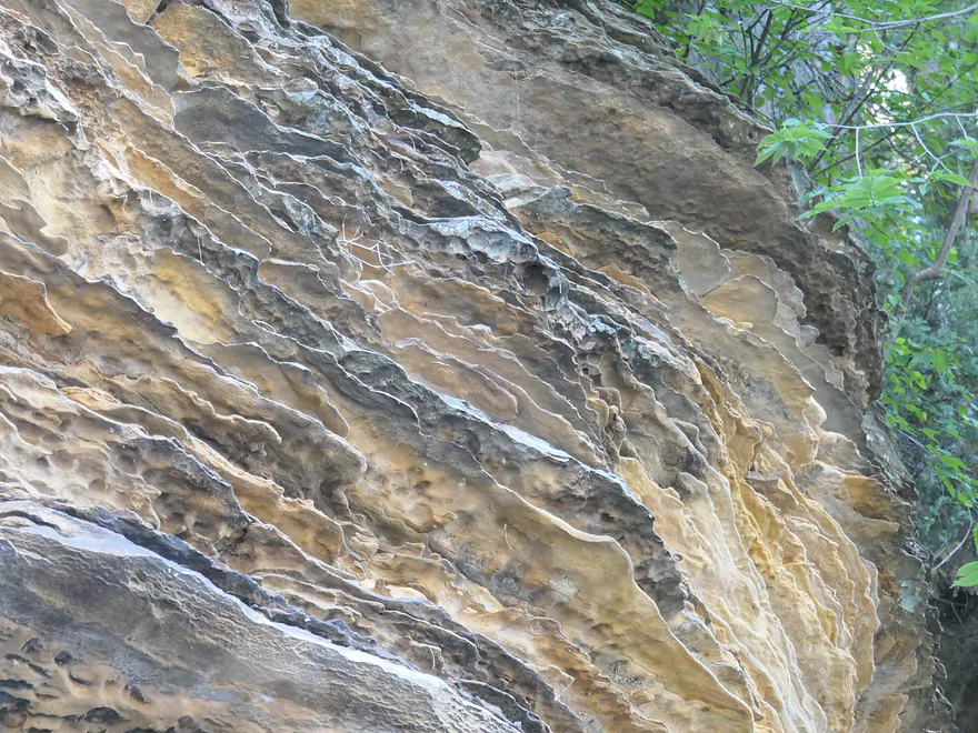
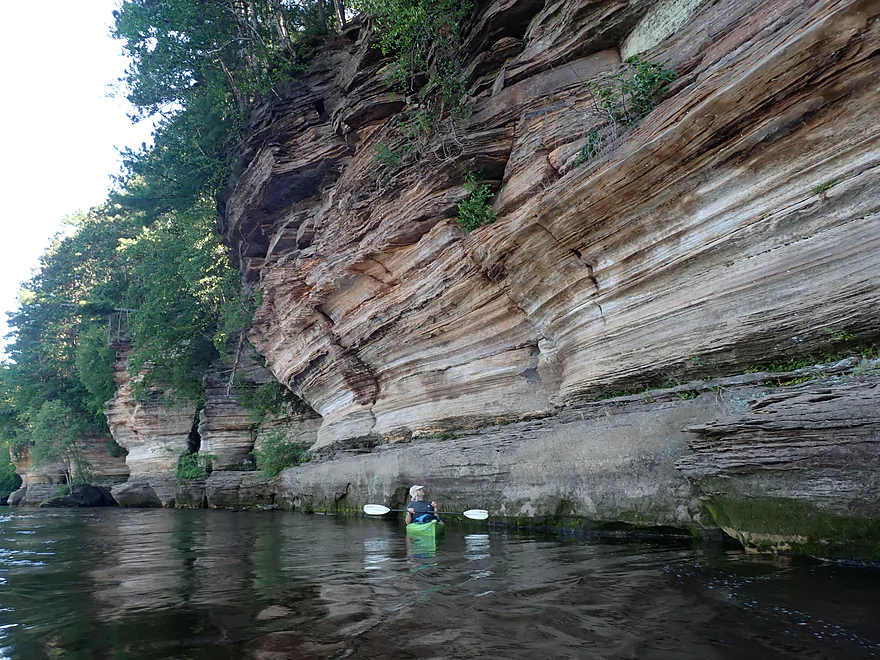
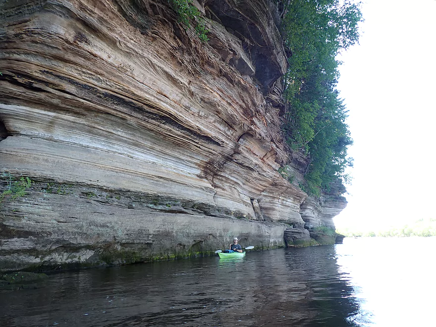
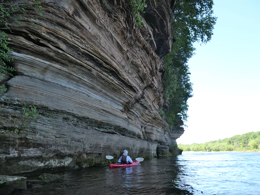
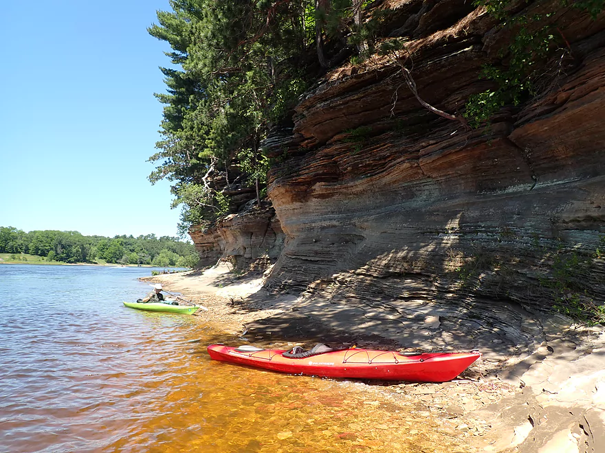
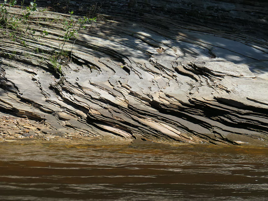
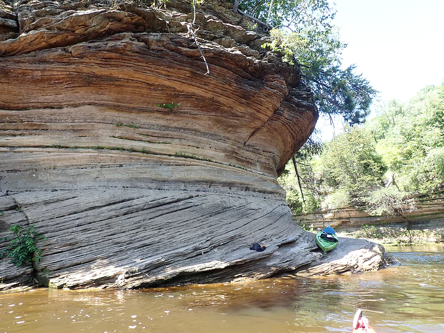
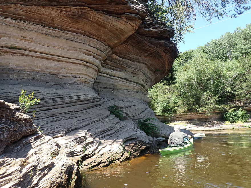
Dells sandstone has terrific texture
“Baby Grand Piano” suffered a partial collapse
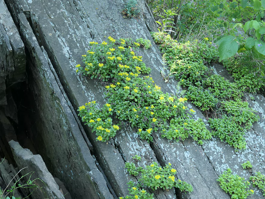
Sedum is growing out of these rock layers
Approaching “Hawk’s Bill”
One of countless nice outcrops along the shore
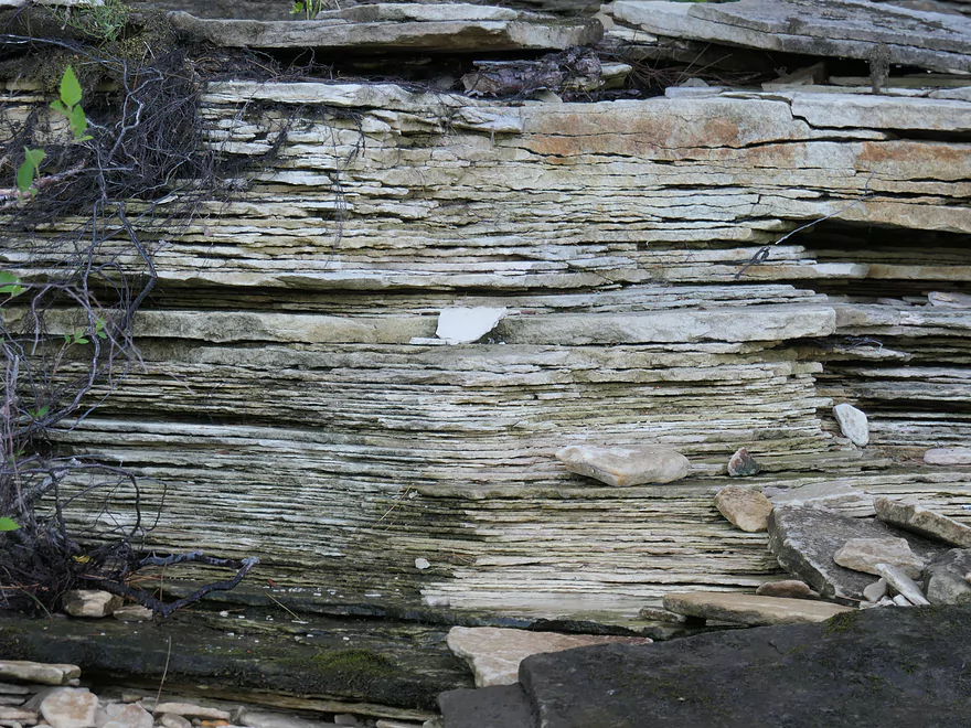
Interesting layering
The famous Dell Creek breach
One of the nicer outcrops
More cool sandstone layers
Newport Park
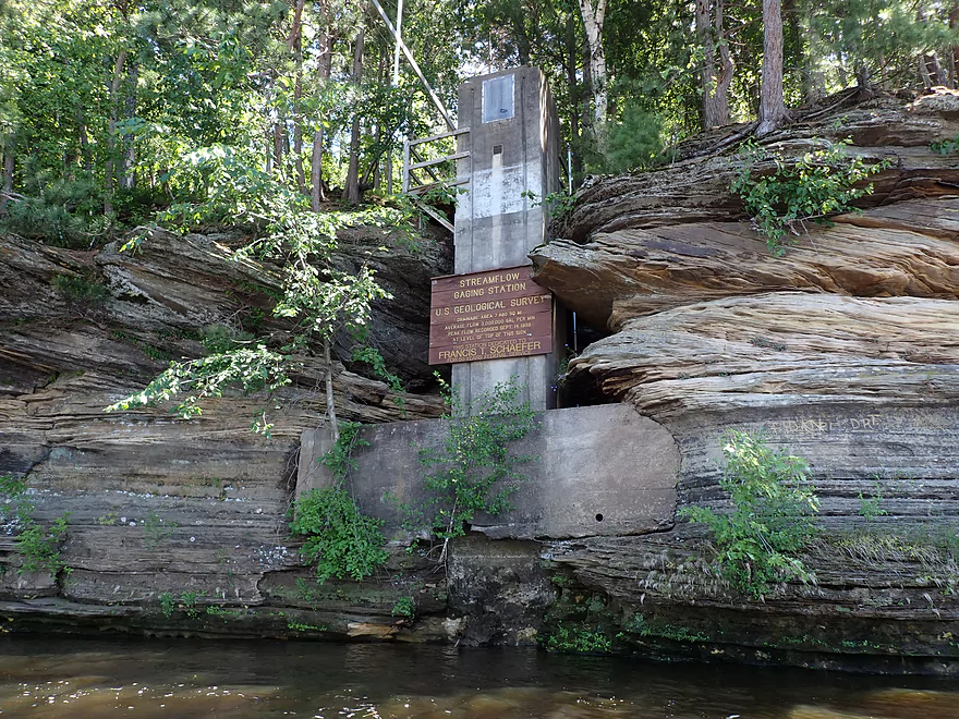
A USGS water gauge (levels doubled during our trip and after a dam release)
Approaching “Rocky Islands”
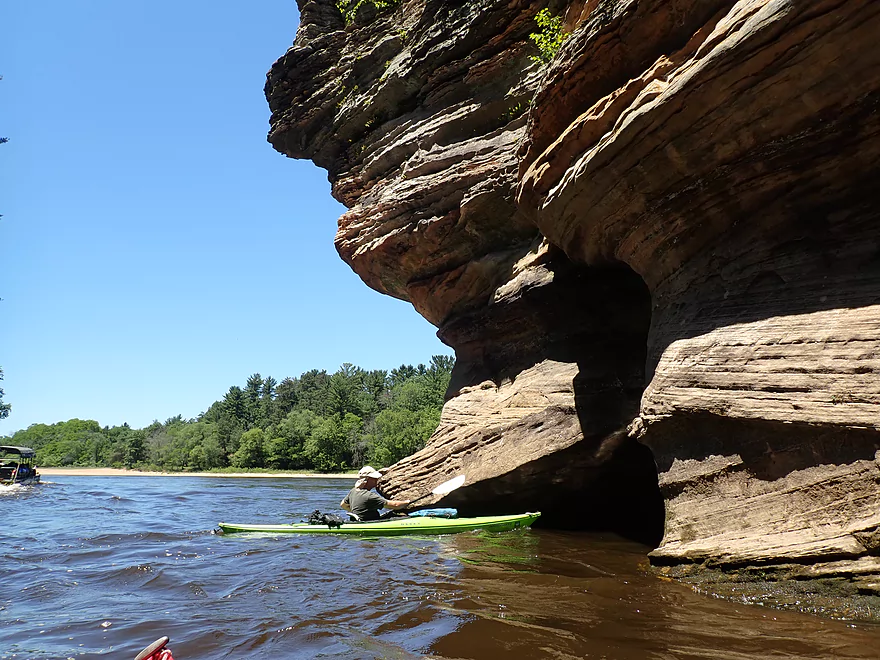
“Grotto Rock” is on the right
It has a fun sea cave
You can enter from one spot and come out another
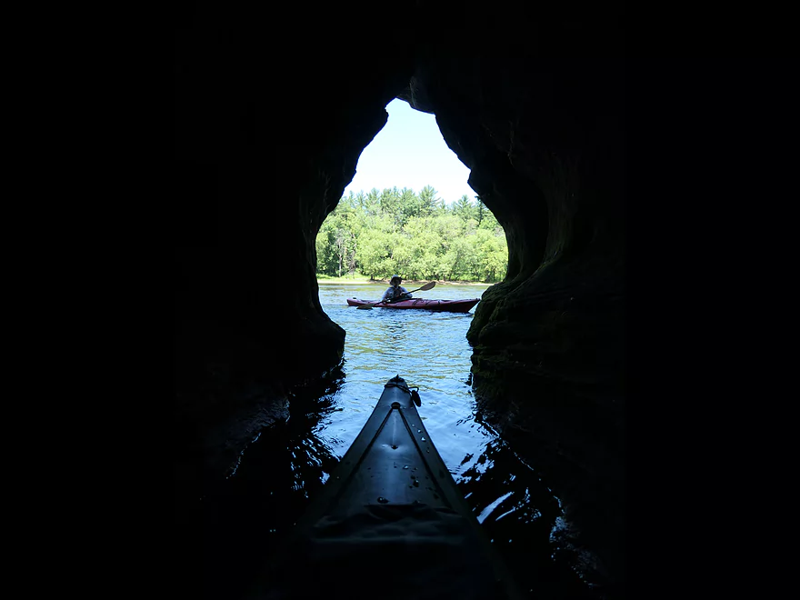
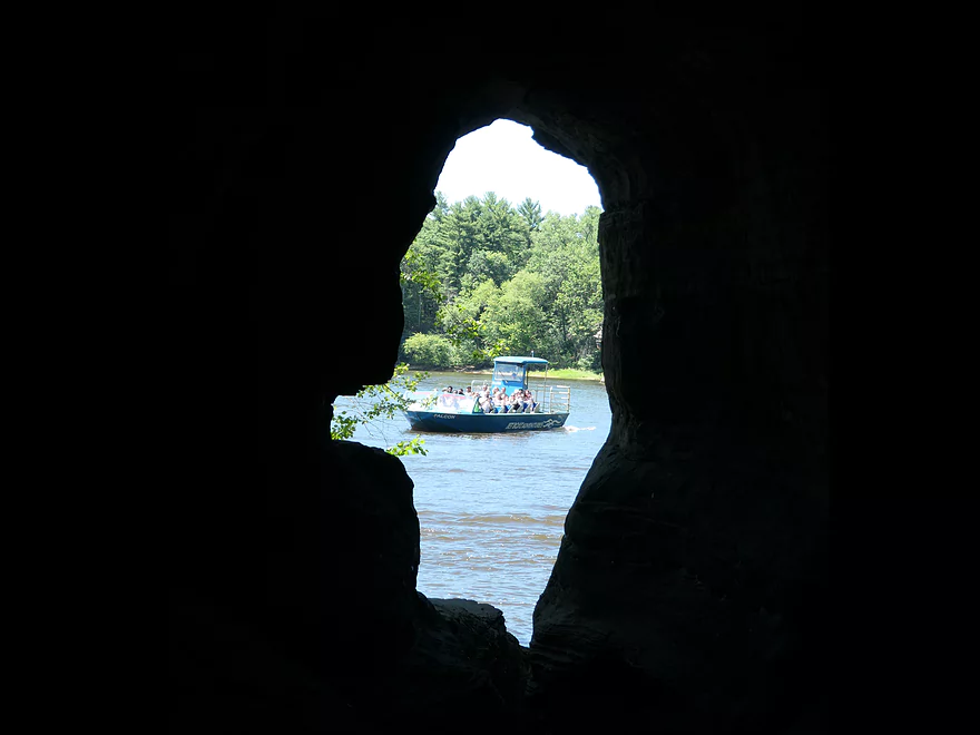
Keyhole vista
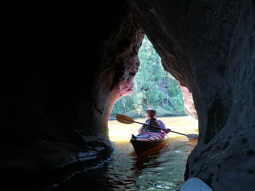
The famous “Sugar Bowl”
This too has a cave one can explore
The halfway point is too narrow for kayaks
This also has some great keyhole shots
Good fun for photography
Time to come out of the Sugar Bowl
Reverse shot of the Sugar Bowl
Crossing the channel…
To take a lunch break on a sandbar
Neat little nook
Interesting rock face
This pillar is missing a giant chunk at the top
This is “Inkstand”
It contains the third and smallest cave
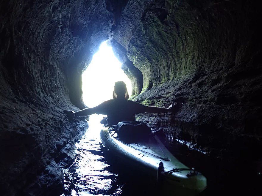
Coming up on “Lone Rock”
Getting out to explore on this island
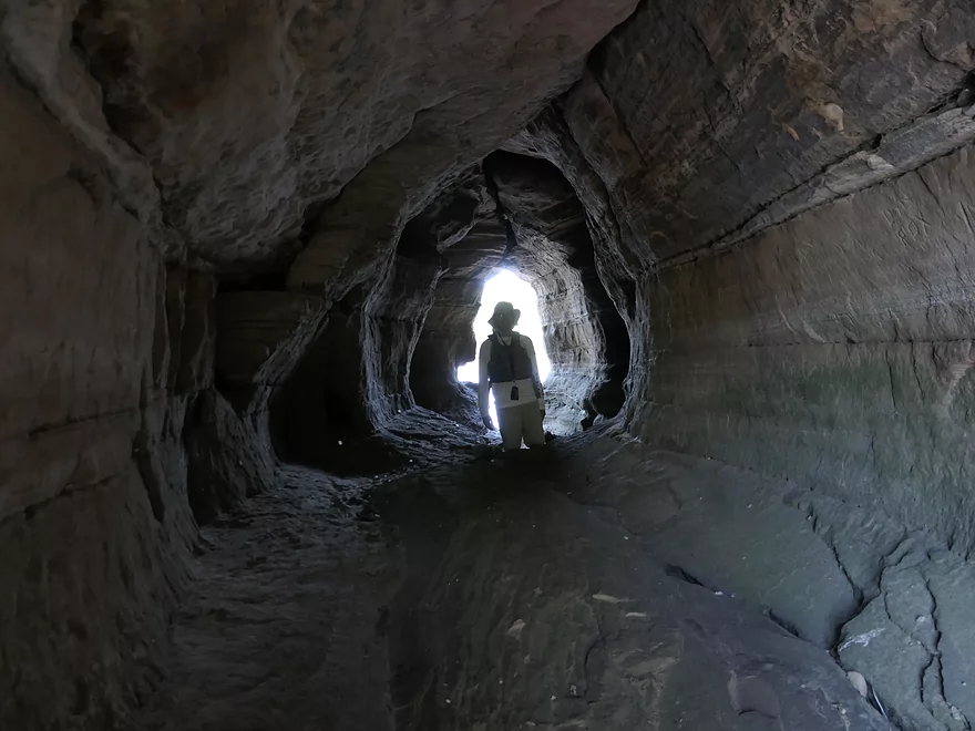
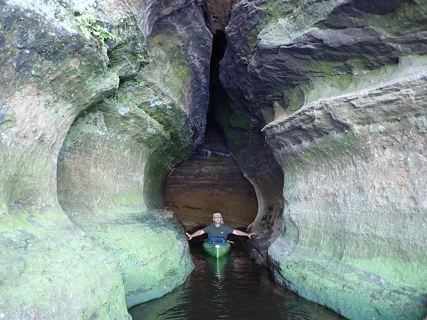
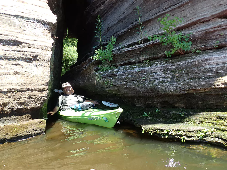
It contains a fantastic cave network with four tunnels
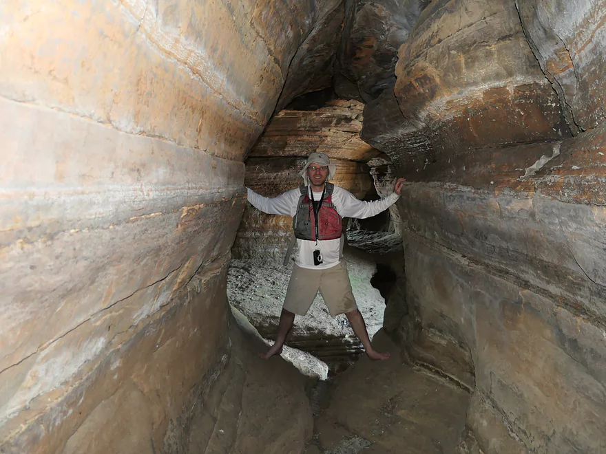
Each tunnel meets in the middle of the island
Looking back toward the entrance
Some fun keyhole shots
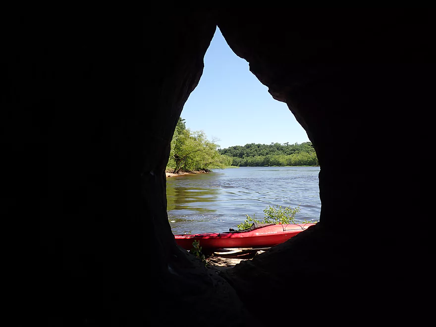
A teardrop
Back on the water
A jet boat squeezes through a narrow channel by the island
From the right angle you can see through the entire island
Reverse view of the island “Lone Rock” (last outcrop of the Lower Dells)
No more outcrops from here until Dekorra (~30 miles)
Interesting rocky shoreline
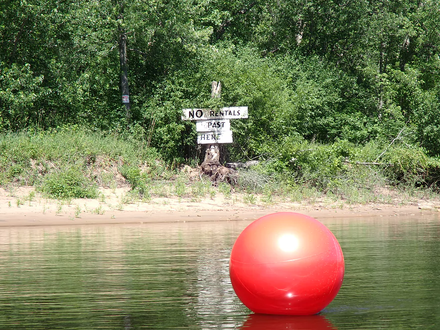
Most boat traffic turns around at the red ball
Very peaceful and calm after that
Some open sand banks
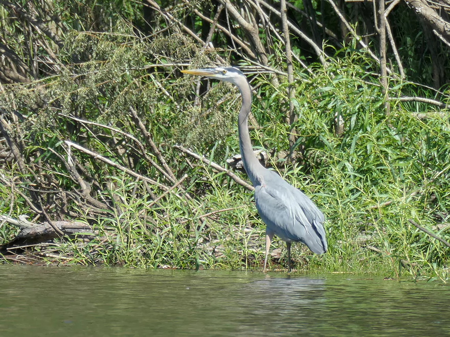
A great blue heron
That fish was still flopping around
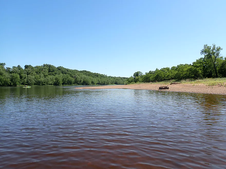
This is “Big Bend” where the Wisconsin makes a huge turn
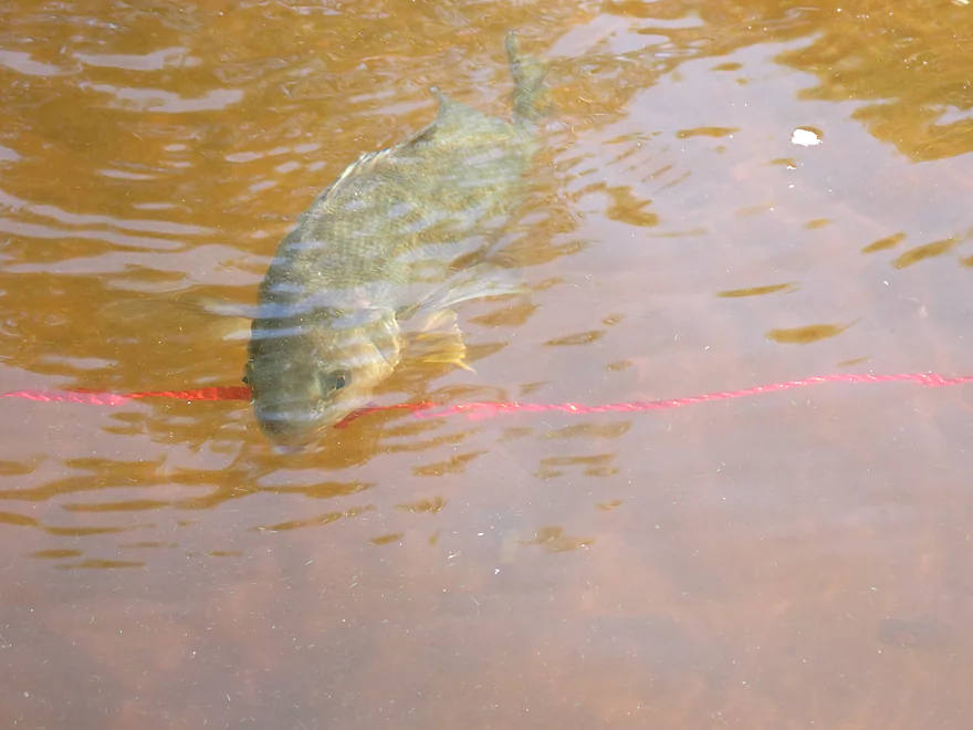
Fish trapped on a lure
Take-out at Indian Trails Landing
Lower Dells

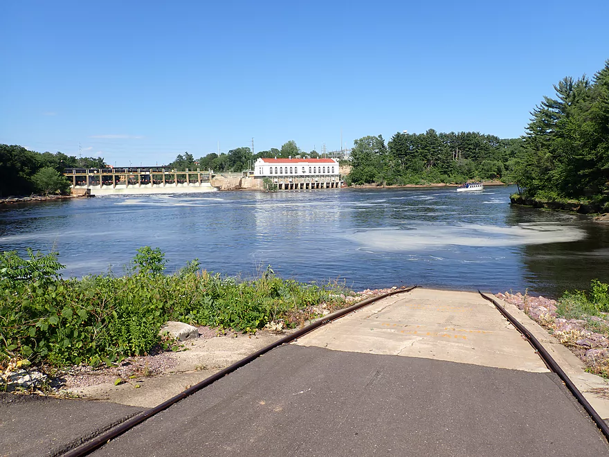
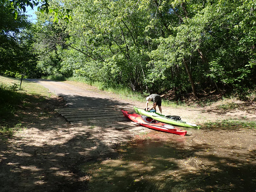
Like most paddlers, we started our Lower Dells trip on the Hwy 12 tour boat landing. This is a huge concrete ramp which the tour boats infrequently use and it is a convenient spot for launching a kayak. Sadly, while this used to be free and open to the public, it is now private and an attendant will chase you down and demand money. The ownership of this landing is complicated and involves multiple shell companies…but in a nutshell it used to be owned by the University of Wisconsin but was sold relatively recently to private investors who now see fit to charge kayakers. Alternatively, one can launch across the river at the Alliant Energy beach which is still free to use and open to the public.
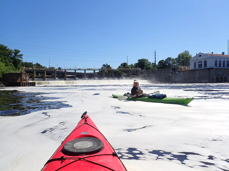
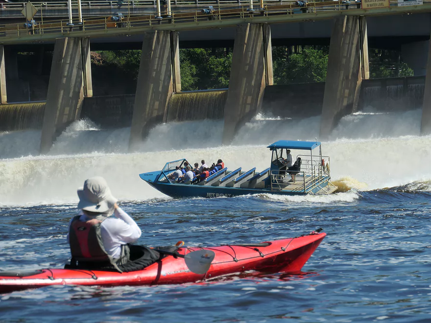
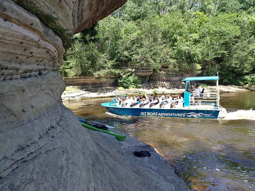
The put-in was back-dropped by the Kilbourn Dam which happened to be sounding multiple release alarms. This was an odd release (given the lack of recent rain) in which the dam operator quickly doubled the size of the river for the weekend (5000 CFS > 11000 CFS). This may have been to assist the commercial tour boat companies for the weekend, but I have to imagine it would be extremely inconvenient for sandbar campers located downstream by Portage and Lake Wisconsin. We paddled as close to the dam as we dared. Here the current was quite strong and huge rafts of foam formed. A daring jet boat got quite close to the dam during the release, and I don’t think they realized the danger they were in. With the gates open there was recirculating current at the base that could trap and flip a boat that got too close (also half the occupants weren’t wearing life jackets).
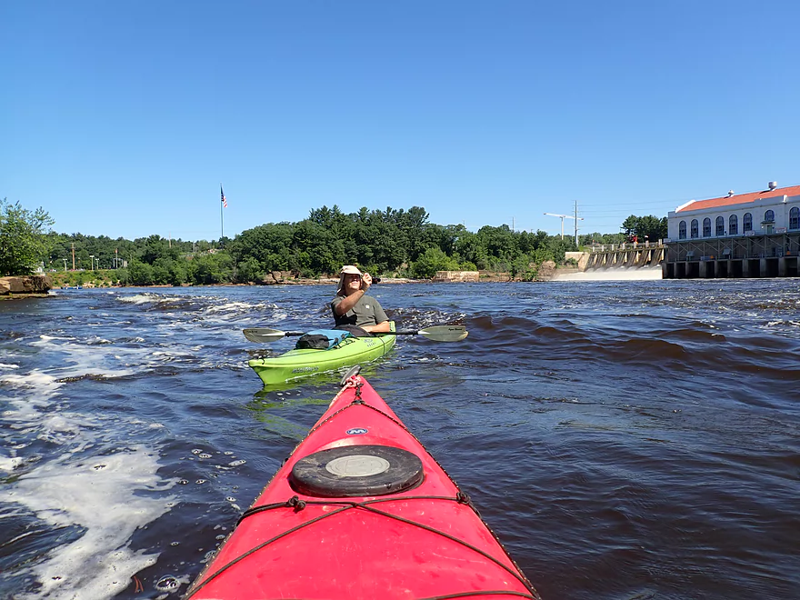
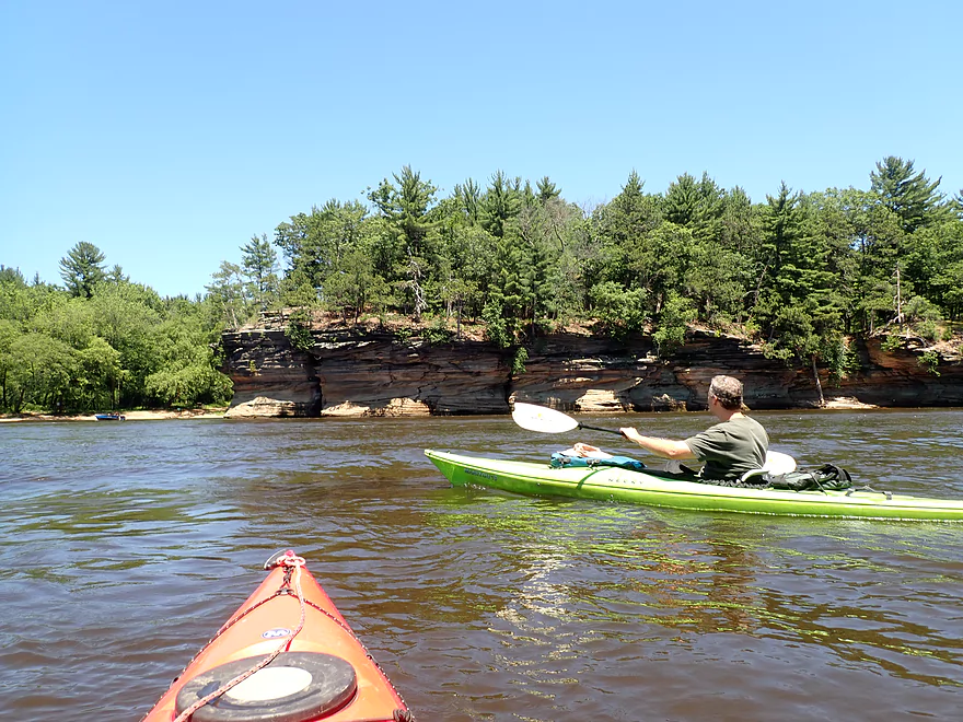
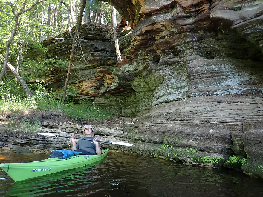
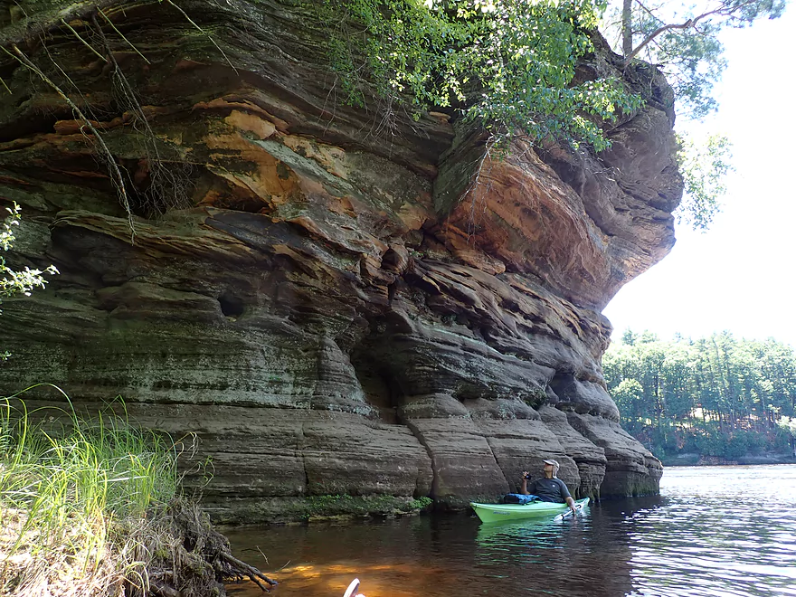
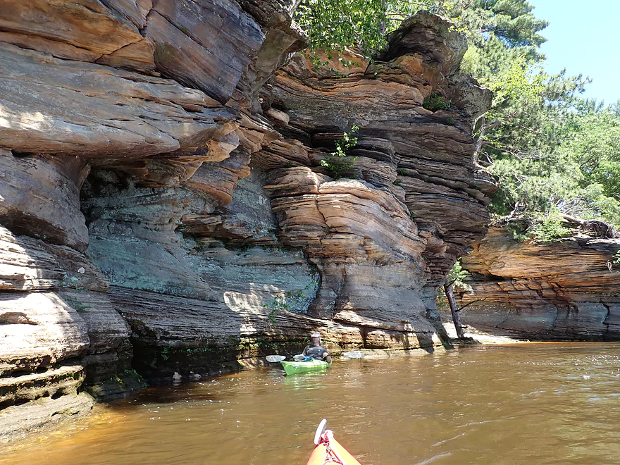
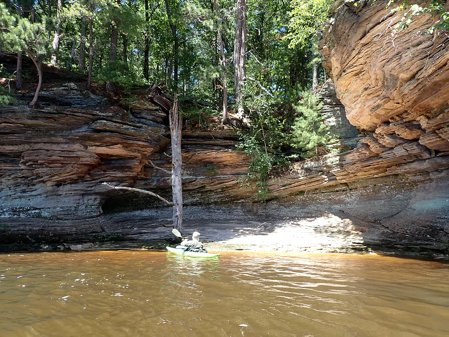
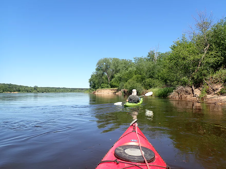
We continued downstream where outcrops lined both sides of the river. Unfortunately these were difficult to see as most in this first leg were well covered by trees. Early spring or late fall would be a great time to do the Lower Dells as the cliffs are then more visible (and there are fewer jet boats on the river).
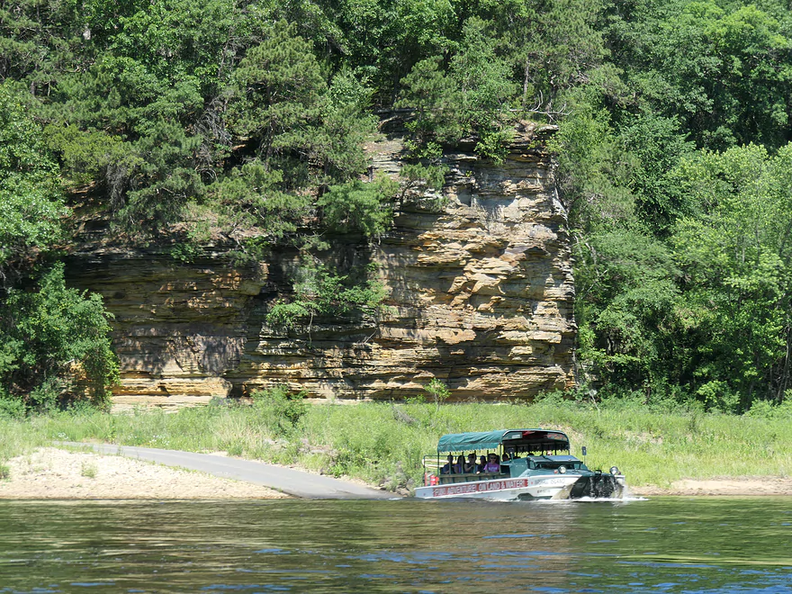
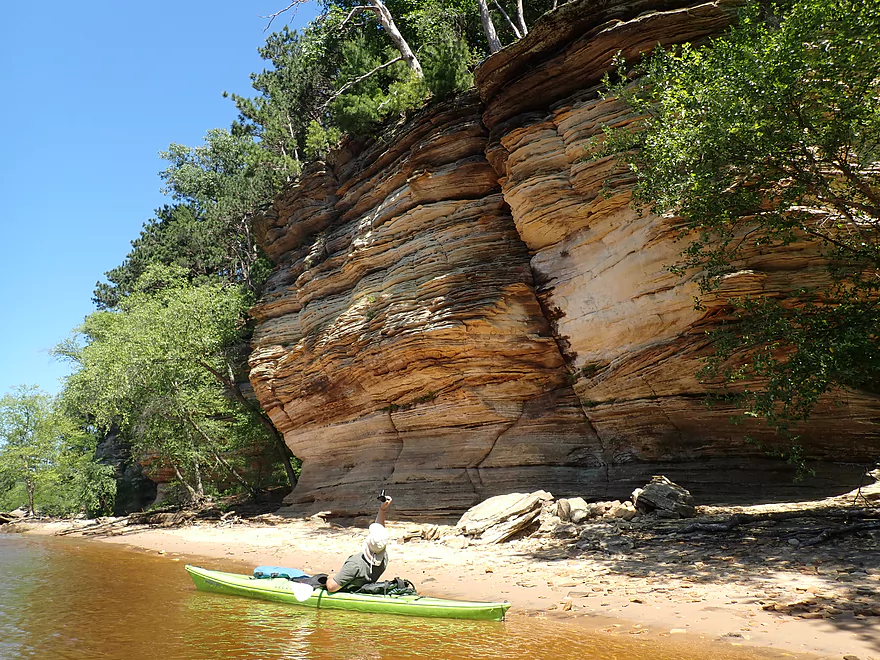
The first major sandstone outcrop is located at Echo Point where the railroad tracks cross a gully (and Amtrak passengers get a great view of the river). Downstream from the main cliff was a popular launch for the amphibious ducks. Thankfully these weren’t very fast and didn’t create a lot of wake…but they had very loud speakers which you could hear for quite some distance. Each guide kept repeating the SAME script. “The Wisconsin is the hardest working river…bla bla blah”. Why not do what museum tours do and let you listen to the narration on headphones or your smartphone? Or just give passengers a script to read…this would save the Lower Dells from a significant amount of noise pollution.
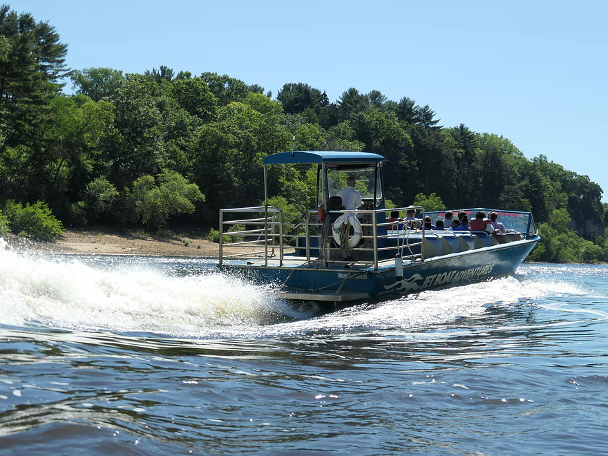
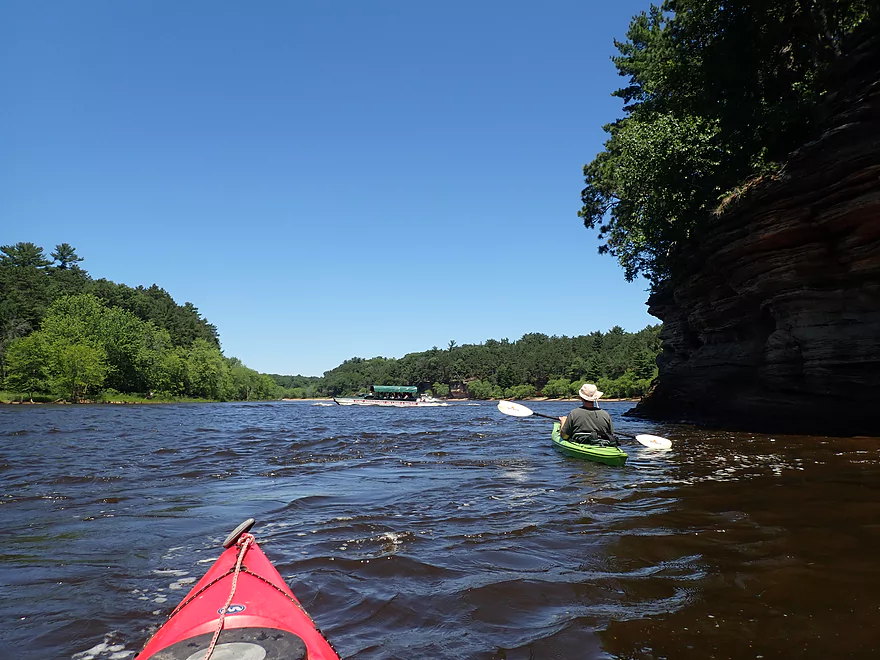
The worst part of this trip were the jet boats. These are bus-sized powerboats that are incredibly fast (over 40 mph), noisy, and create huge waves that will swamp you if you aren’t vigilant. Each time one passed (which happened a lot) we had to align our boats to face the waves to avoid capsizing. These huge boats would frequently do obnoxious corkscrews to the delight of their passengers, but to the annoyance of everybody else. I’m shocked the DNR lets them operate on the Wisconsin River. The noise and wake they create must spook a lot of wildlife and fish.
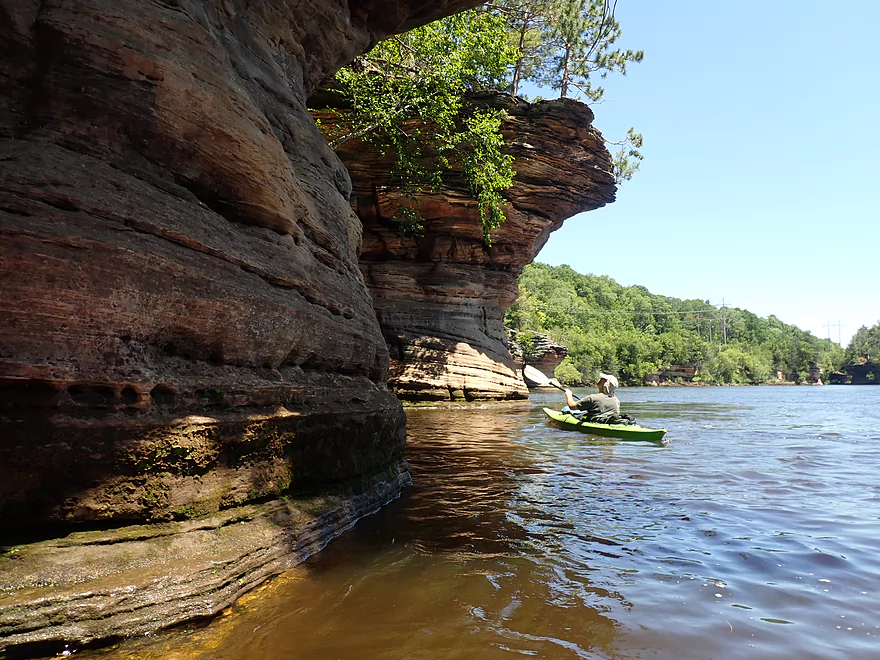
Next on our left we passed the iconic outcrop known as “Baby Grand Piano”. Here a massive sandstone overhang tipped over and fell partly into the river. This was tragic, but in some ways predictable, as the sandstone is constantly being eroded by natural forces. I have to think the massive waves created by the jet boats are also significantly eroding the scenic shoreline and could result in future degradation of the iconic Lower Dells, but nobody in power seems to care.
We continued down the river seeing more iconic outcrops such as Hawk’s Bill. On the right we came to the area where a major breach of nearby Lake Delton occurred after several days of rain in 2008. The dam on Dell Creek held, but the flood waters washed out the adjacent road and created a direct channel to the Wisconsin River. Five homes were lost and the entire lake was drained. The breach area has since been filled in and is now just a grassy open area.
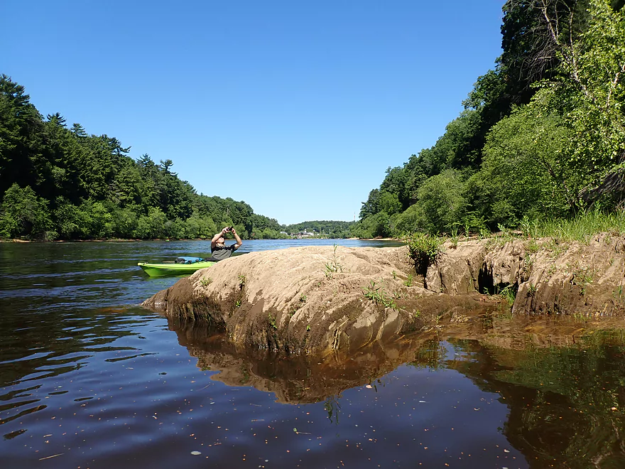
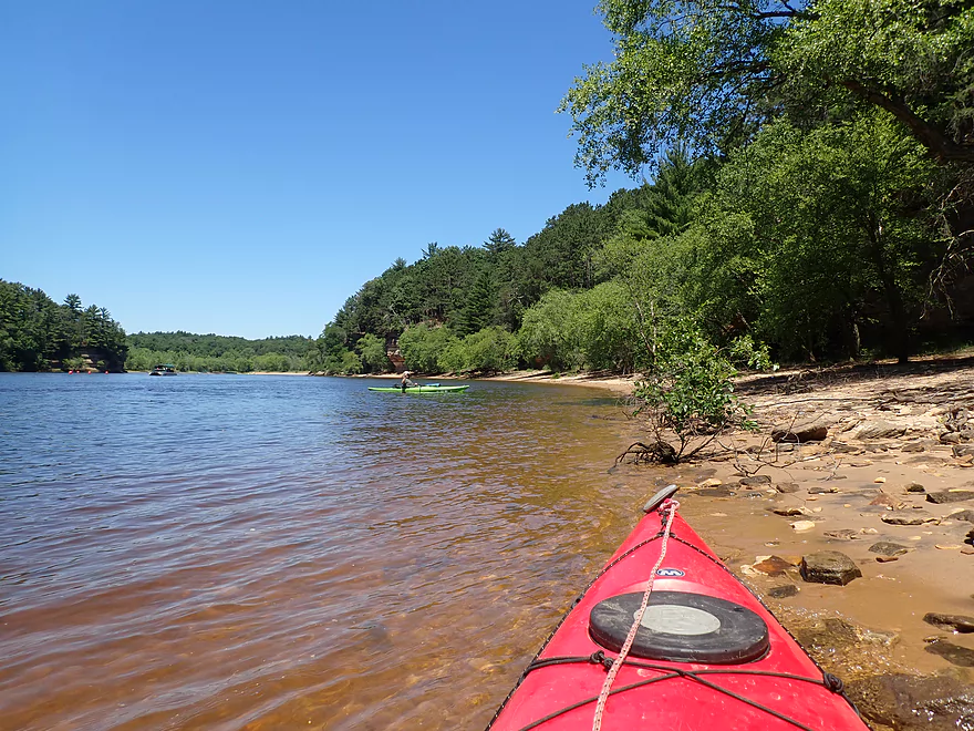
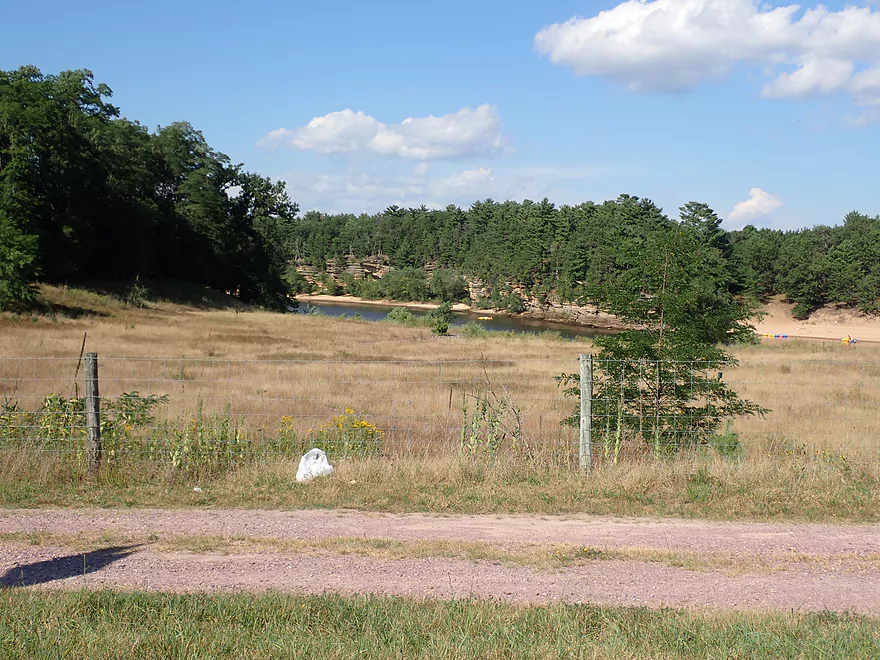
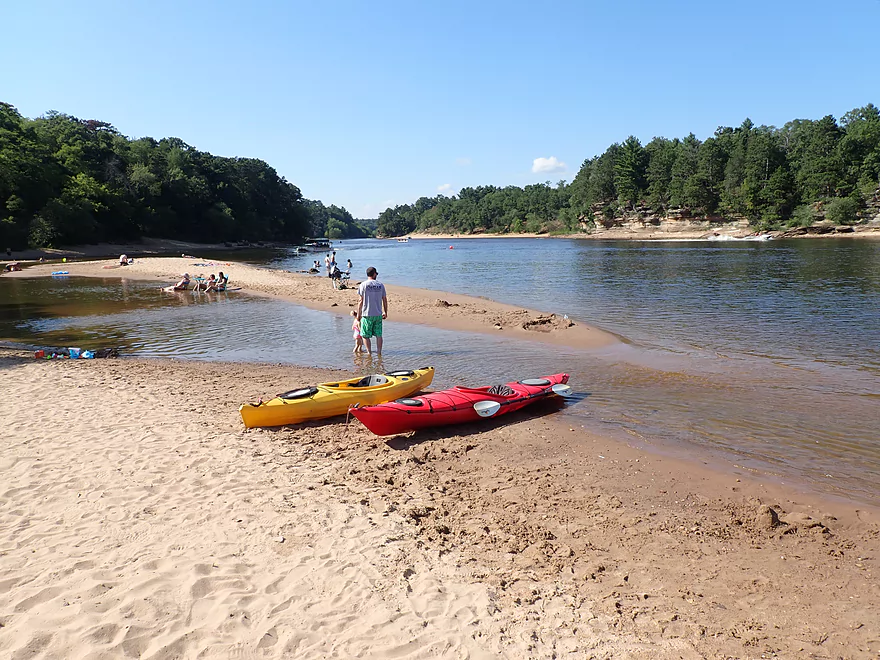
Just past the breach area is Dell Creek, where Duck boats switch from propellers to wheels and head inland from the main river. And just past Dell Creek is Newport Park. This is a relatively new park and is one of the few places where the public has access to the river in the Lower Dells. It also has a great beach (although busy from all the nearby boat and Duck traffic). Although many paddlers take out at Newport Park, that is a mistake as just downstream from here is one of the nicer areas of the river.
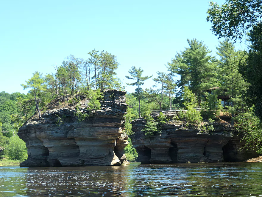
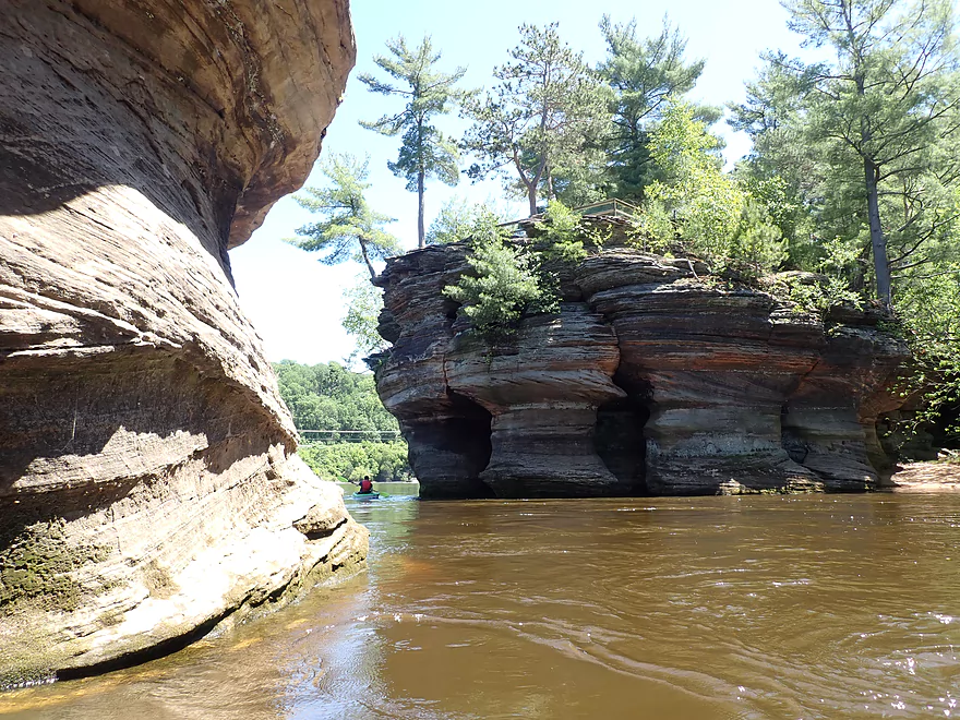
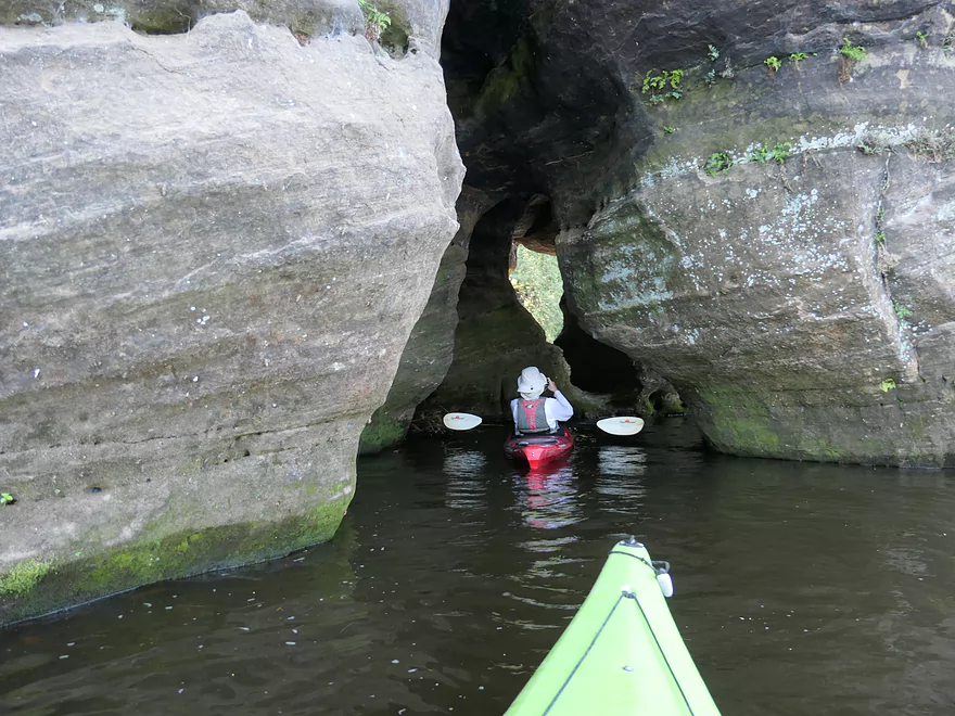
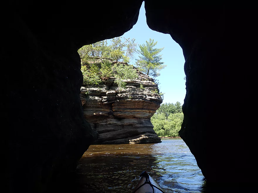
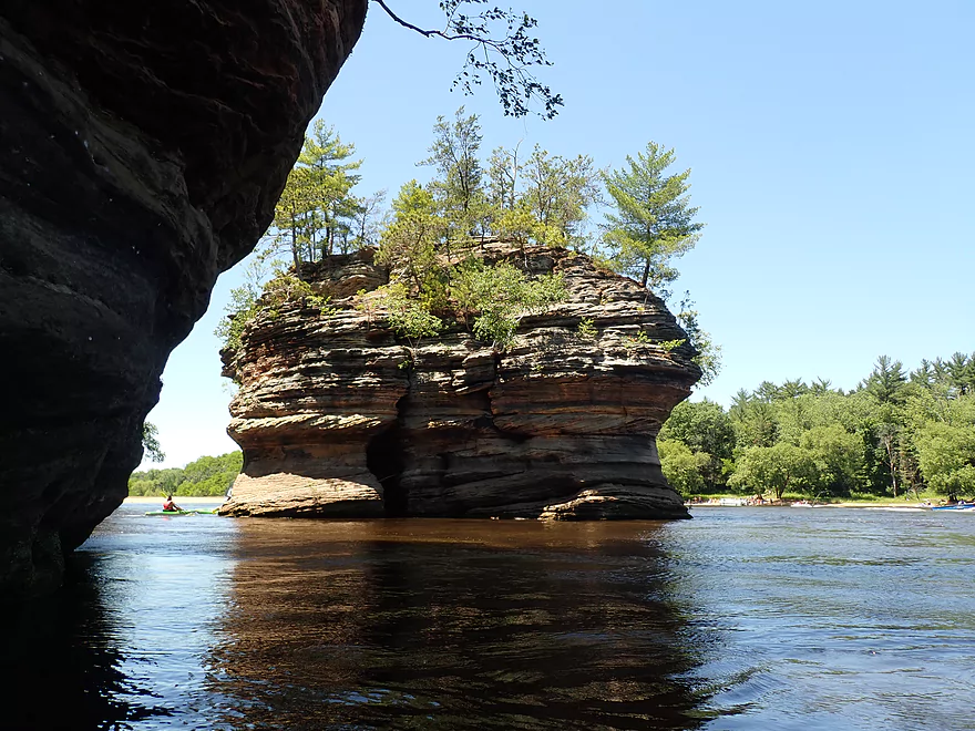
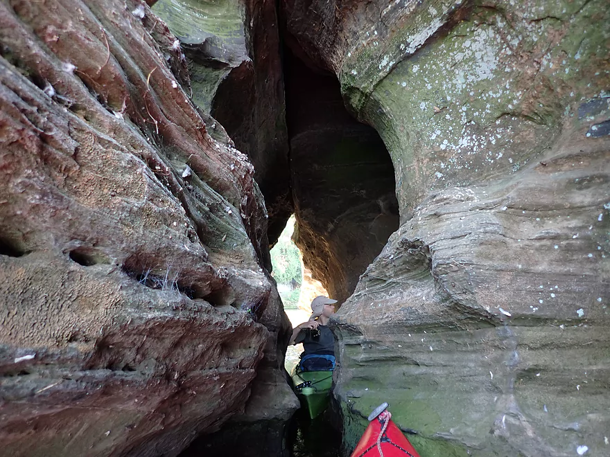
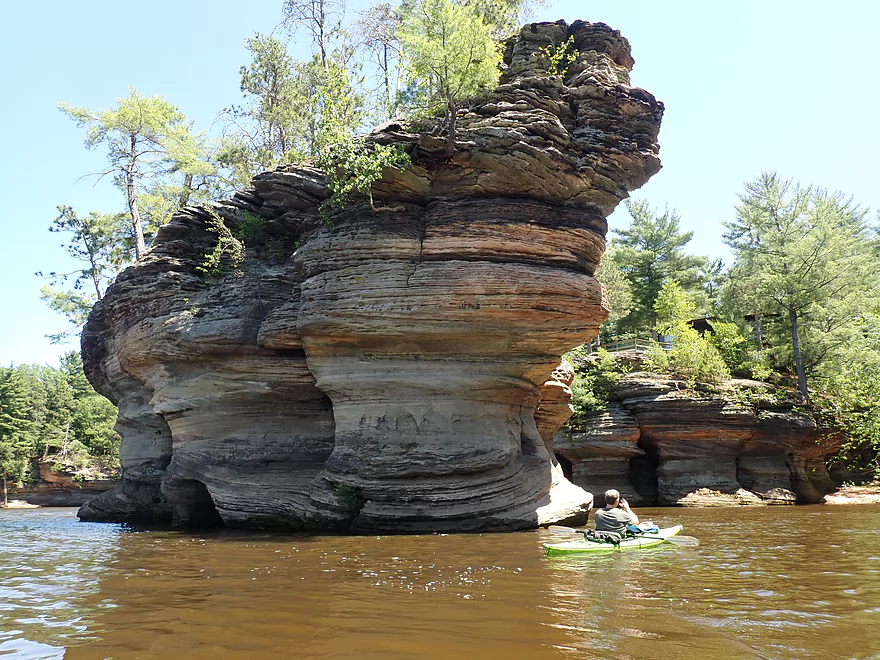
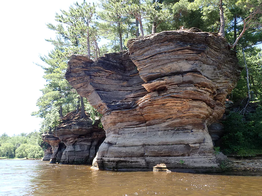
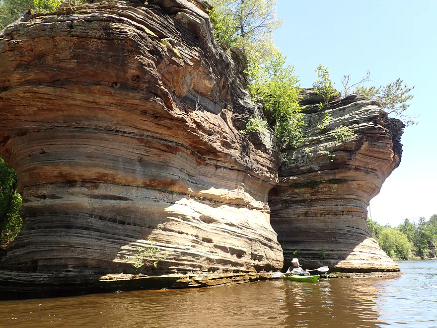
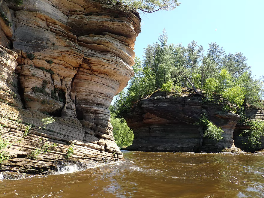
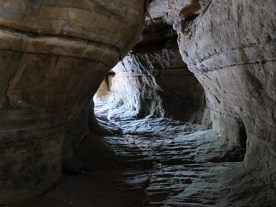
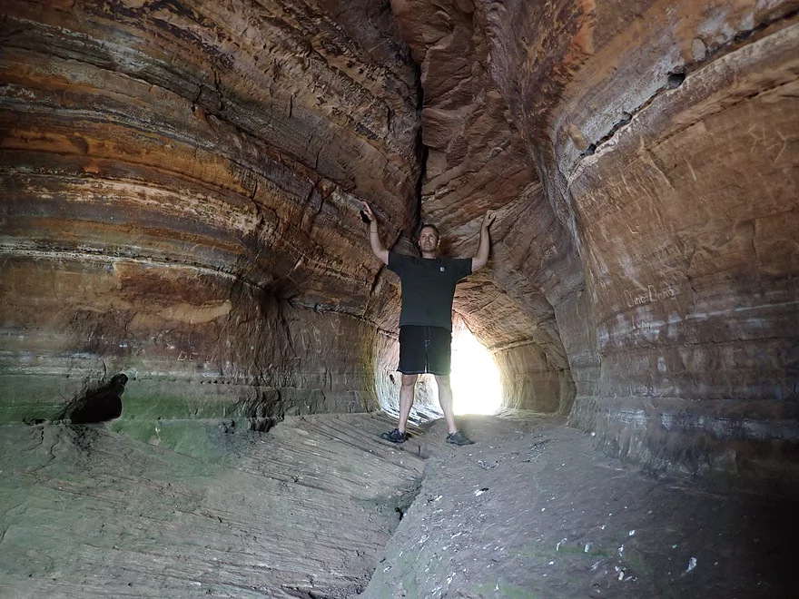
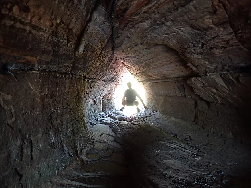
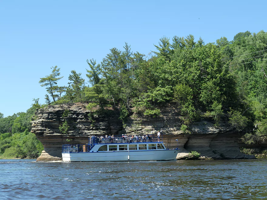
Just around the bend from Newport are the “Rocky Islands” one of the most iconic scenes of the Lower Dells. If you see a picture or postcard labeled “Lower Dells”, chances are it will be this very spot. Along the right is “Grotto Rock” which is a rocky peninsula that juts out onto the Wisconsin River. Nearby is a tall narrow island known as “Sugar Bowl”. Visible much further downstream is “Inkstand” a rocky peninsula which is likely a future island in the making. This is followed by the largest freestanding rock formation on the Lower Dells known as “Lone Rock”.
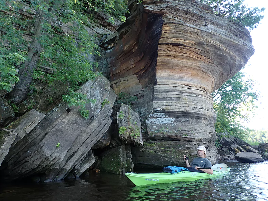
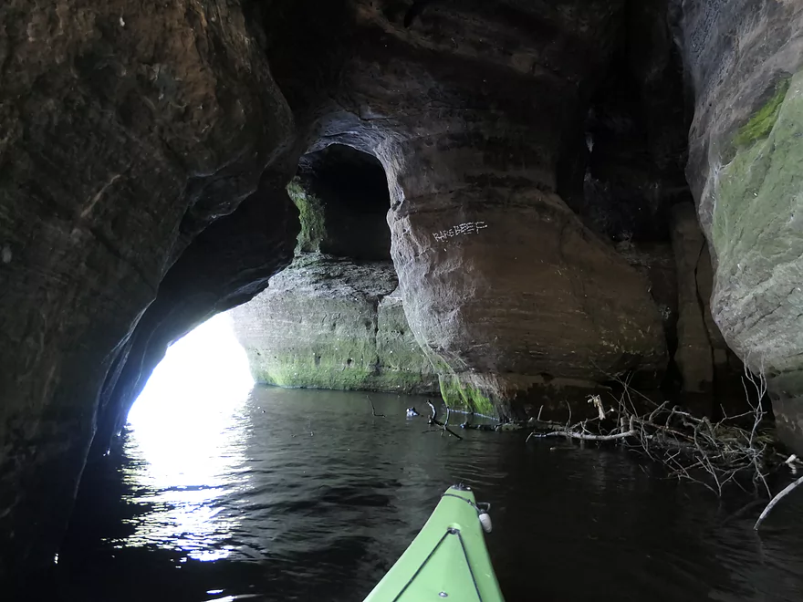
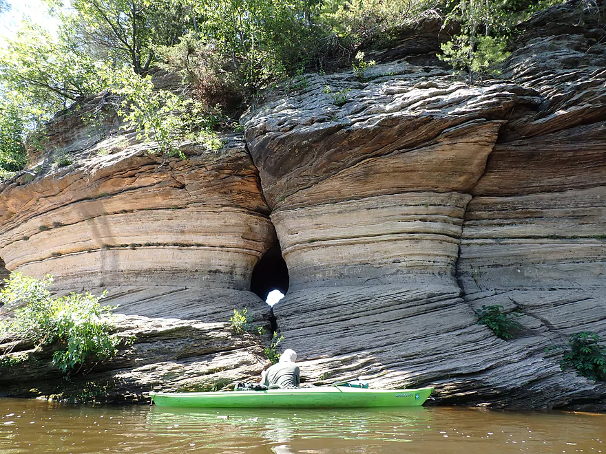
Underneath the “Grotto” is the first cave you can paddle into. The tunnels bisect the cave so you can enter from one point and exit from another. The second cave is under Sugar Bowl. There is a constriction in the middle so you can’t completely paddle through the island, but this cave network is more scenic than the Grotto’s. This was all fantastic, but a little risky. If/when a jet boat were to go by, the waves could pin or flip any kayak that happened to be in the caves. We constantly had to keep our ears peeled for these menaces.
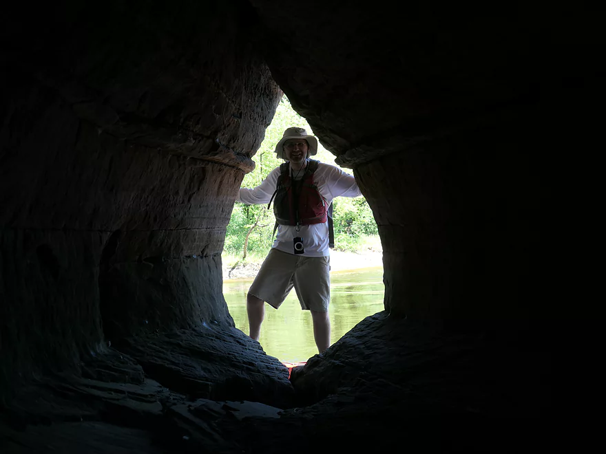
After a lunch break on a sandbar, we continued downstream past the last of the Lower Dells outcrops. First there was “Ink Stand” which had the smallest cave, and this was soon followed by “Lone Rock”. This scenic rock island was covered in exotic sandstone patterns and was also bisected by two tunnels that met in the middle. But while the previous three caves were at the water line, this was above water and couldn’t be explored by kayak. We did get out to explore by foot, but as a warning this isn’t recommended for most paddlers. This is because there is no easy way to dock on the island, the channel is fast/deep here, the interior is slippery with surprise drop-offs that could break a leg, and bird poo is everywhere. That being said, it was the largest and best cave network of the trip.
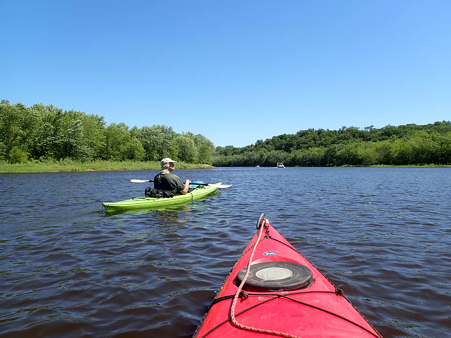
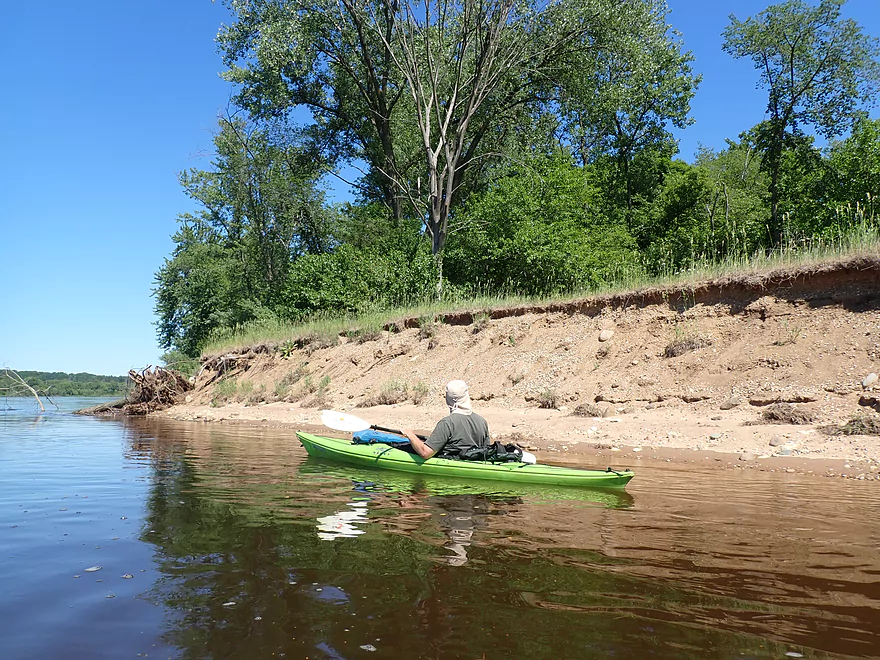
The final four miles saw a major transformation in the river. Sadly, there were no more sandstone outcrops or terrific scenery. But we did lose all the other people, waves, and noises…resulting in a mundane but peaceful and pleasant paddle. One of the highlights of the second leg was “Big Bend” where the river makes an almost 360 degree turn back on itself with a large gravel bar on the inside. A decade ago when I paddled this, there were remnants of a Lake Delton home that had been sucked out of Dell Creek, but we didn’t see anything now. We ended the trip at Indian Trails Landing which was a nice access with surprisingly few people.
In summary, this was a great trip but there were problems. The boat traffic was not only annoying, but bordered on being dangerous. Then there were all the noises…the car alarms, dam release alarms, church bells, motor boats, tour boats, the tour boat megaphones, the yelling kids, and even car traffic. One trick to avoid this chaos is to go at an off-peak time (weekdays, spring, fall).
Many rivers and creeks in Wisconsin have outcrops, so how do the ones on the Lower Dells compare? Well the sandstone cliffs on the Dells are unique because of their size, frequency, and exotic textures. The outcrops on the Upper Dells are bigger, but there you have more open water to deal with. Dells kayaking newbies should start with Mirror Lake. This is because its no-wake protection makes it a great paddle and the easiest of the Dells water trails.
Lastly, you might wonder why not just take a boat tour to explore the Lower Dells? Many reasons…with a kayak you go at your own pace, you can get much closer to the cliffs, sandbar picnics are possible, and you can explore all four caves.
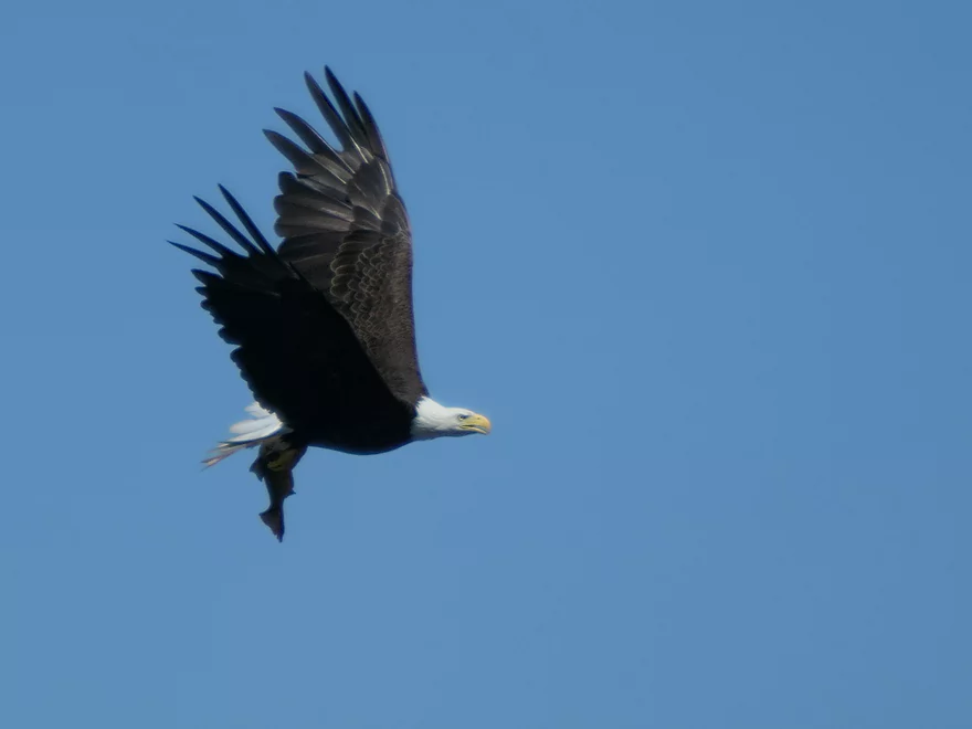
Sights included ducks (the real kind), a great blue heron, quite a few pigeons, turkey vultures and a red-tailed hawk. The highlight was the eagles…one of which caught a fish in front of us. The lowlight was a baited setline with multiple hooks on it. Four fish were attached to it (one dead). The owner wasn’t attending the lines so the fish just had to sit there with a hook in their mouth for what was likely hours.
Hwy 12 (Below the Kilbourn Dam): Just below the dam is a large concrete maintenance ramp for the big tour boats. This is a decent kayak launch and is adjacent to a large public parking lot. But..while previously this used to be free, you now have to pay a fee to use it ($5 per person). There isn’t a pay booth per say…but a local attendant will find you and demand their money.
Alternate Put-ins:
- Illinois Ave (0.8 miles upstream of Hwy 12): There is a public access for kayaks west of the road (not to be confused with the nearby boat ramp which requires a fee). Launching here for a Lower Dells trip will require portaging the Kilbourn Dam. There is a marked portage path, but it isn’t easy and will require ~2000′ of boat dragging.
- Finnegan Ave Beach (1500′ downstream of Hwy 12): Just south of the Alliant Energy powerhouse there is a steep but doable public fishing trail that leads to a beach. If you don’t like paying fees to use the tour boat ramp across the river, then this is the better option.
Indian Trails Landing: This is a great public launch and I was surprised to see so few using it. Perhaps this is due in part to the mouth being partly silted in…or a sign that prohibits commercial activity. Note this landing is a bit tricky to find and can be easy to overshoot, so study a map before doing the trip. When you see a boat ramp on your left, that’s when you need to turn sharply right and head up a hidden slough to reach the ramp.
Alternate Take-outs:
- Norway Drive Boat Ramp: This is a boat ramp located directly across from Indian Trails landing. It is free to the public and more popular, but will require shuttling east of the river.
- Newport Park (4.2 miles upstream from Indian Trails Landing): This is a large public park that features a beach and boat ramp. As long as you don’t park in the trailer parking lot, you don’t have to pay the considerable launch fee. An overflow parking lot is located north of Dell Creek on Hwy A. Most paddlers will end their trip here, but that is a mistake as you miss the Rocky Islands which is a trip highlight. Although the current here isn’t too fast, so in theory paddlers could intentionally overshoot Newport to see the last of the Lower Dells, and then double back to take out at Newport. My personal preference is to just paddle the additional four miles to Indian Trails Landing.
Bike Shuttle – Indian Trails to Kilbourn Dam: 4.4 miles with 249′ of ascent. This bike shuttle isn’t too long, but does feature one significant hill to climb.
Rental/Shuttle – River’s Edge Resort: They offer kayak rentals and/or shuttles. Most just launch from the resort and do a loop on the Lower Dells before returning. But they will shuttle you to the dam if you request it. I believe this costs $25-30 dollars, but don’t quote me on that.
Dam: Try not to get too close to the dam, as there is recirculating current at the base. An alarm will sound prior to a release. During our trip they did a significant release and practically doubled the size of the river in just a few hours.
Current: Parts of the Lower Dells are quite fast (mostly the narrow stretches and just below the dam). Doing a long round-trip likely isn’t viable. The speed of the current is proportional to how much water the dam is letting out.
Caves: Three caves can be explored by kayak. This is a really neat experience but is dangerous. When a jet boat goes by it can create significant wake which can trap and overturn your boat in these narrow tunnels. If you go into the caves, keep your ears peeled for powerboats and exit ASAP at the first sign of trouble.
The fourth cave is mostly above water (in the island “Lone Rock”). You can’t paddle into this, but can hike into it. Be warned though… There is no easy way to dock on this island (the channel here is deep and fast). The base of the cave is slippery and there are open areas where you could fall and break your leg if you’re not careful. Finally there is bird poo everywhere in this cave.
Waves: This is a narrow part of the Wisconsin River that features many motorboats. Waves are a big problem as they often don’t dissipate along the shore but instead bounce off the rock walls and back onto the channel. The absolute worst are the jet boats (bus-sized jet-skis). These travel 40+ mph and create massive waves which will swamp your kayak if you’re not prepared. When you hear a jet boat coming, get clear of any rock outcrops and face the waves head-on to reduce the chance of capsizing. I absolutely recommend wearing a life jacket for this trip.
Lower Dells Gauge: Trip done at: 10,750 CFS or 5.3′
- 0-4,000 CFS: A low depth, but possibly an excellent target range as I think this is too shallow for the tour boats.
- 4,001-6,000 CFS: An average summer depth. Nice sized sandy areas along the bank.
- 6,001-8,000 CFS: An average spring depth. Current is faster.
- 8,001-12,000 CFS: A higher depth with fast current in spots.
- 12,001-14,000 CFS: A very high depth. A trip is likely viable, but the current will be pretty fast in spots.
- 14,001+ CFS: The main channel might be too dirty and fast to be enjoyable for paddling.
The Wisconsin Dells represents one of the worst tragedies of public conservation and environmentalism in state history. Very powerful local businessmen (most from out-of-state and Chicago) have monopolized/feudalized the Dells for immense profit, corrupted its local politics, and degraded public access. Few know the complete story, but I’ll try to share some rarely known tidbits.
- Wisconsin Dells Dam: This has been the single greatest tragedy. Yes…the Upper Dells are nice…but they were far, far nicer before the dam. The dam produces a measly 10 megawatts (just 1/100th of the nearby Columbia Plant). Hopefully one day it will be removed, but this is doubtful because the politically powerful “Dells Boat Tours” company relies on the dam to provide sufficient water for their oversized boats to access Coldwater Canyon and Witches Gulch on the Upper Dells. In the mornings and weekends, the dam also does special releases on the Lower Dells to help out the private tour boats (but is not so considerate to downstream sandbar campers). HH Bennett was a major critic of the dam as he complained its 55-foot height would submerge the best parts of the Upper Dells. His photo collection contains some of the few pre-dam pictures taken of the Upper Dells. An example of this can be seen on the header of the “Friends of HH Bennett Studio” Facebook page.
- The Failed State Park: In 1906 there was a serious effort to convert Devil’s Lake and Wisconsin Dells to state parks. Sadly only Devil’s Lake succeeded. Today there is Mirror Lake State Park and Rocky Arbor State Park, but they protect only a pittance of the entire Dells.
- The Failed National Park: In 1934 an effort was made to create “Wisconsin Dells National Park” which would have spanned from the Lemonweir River to the Lower Dells. It would have been fantastic and had the sponsorship of a senator, but sadly failed.
- Who Owns the Upper Dells: Much of it used to be owned by George Crandall. He feared it would be destroyed by development so he worked hard to buy up and protect as much of the land as he could. He would eventually donate much of the Upper Dells to the University of Wisconsin under the naive belief they cared about conservation and public access. Wisconsin (through their for-profit corporation WARF) semi-protected the Upper Dells, but mostly used it to generate immense profit for its tour boat corporation “Dells Boat Company”. Eventually WARF/University of Wisconsin sold much of the Upper Dells to the DNR, but stipulated that its corporation “Dells Boat Company” would continue to receive exclusive access to the main landmarks (Stand Rock, Witches Gulch, Coldwater Canyon, etc…). The DNR sadly agreed. Later WARF sold the “Dells Boat Company” to private investors who now through poorly written leases have exclusive access to the jewels of the Upper Dells despite being publicly owned. Hopefully the DNR will one day wake up, realize the mistake they made, and give much of the Upper Dells to Rocky Arbor State Park to administer for public access.
- Who Owns the Lower Dells: This is similar to what happened to the Upper Dells. Much of the Lower Dells was semi-protected by the University of Wisconsin and maintained to run its tour boats. WARF then sold part of the Lower Dells shoreline to the DNR, but sadly a much smaller percentage than what was done for the Upper Dells. A significant portion of the Lower Dells remained in ownership by the “Dells Boat Company”. This was done in part to allow access to the main tour boat launch and to allow for exclusive access to its duck boat trails. Sadly, the “Dells Boat Company” was then later sold by the University of Wisconsin to private investors. In a sneaky sleight-of-hand using shell companies and secretive transactions, much of the Lower Dells is being transferred from the public to private investors. There will likely be more development, public restrictions, and fees because of this.
- Lower Dells Tour Boat Landing: When WARF/University of Wisconsin owned this, they allowed the public to launch their kayaks here. This used to be the main launch point for Lower Dells trips. Sadly this landing is now owned by private investors who have started to charge kayakers $5 to use the landing.
- Blackhawk Island: This is a fantastic island with scenic outcrops that is publicly owned…but…not open to the public. Instead the state (through the university system) has given exclusive access to the nearby 4H club (Upham Woods) which itself is a strange public/private hybrid institution. Rocky Arbor State Park is next door and could easily administer the island and balance the challenges of public demand. The other tragedy is there used to be a key canoe landing by Blackhawk Island…which the 4H club shut down because of “safety” reasons. There was an outrage in the community but nothing came of it.
- Steamboat Island: One of the most iconic landmarks of the Upper Dells is Steamboat Island which is super scenic. Tragically a large resort (Chula Vista) was built on top of the cliffs which is an eyesore. Today Chula Vista is one of the owners of “Dells Boat Tours” and its Lower Dells land holdings (which used to be publicly owned by WARF).
- Tour Boats: Many of these boats use loud speakers and the noise pollution they emit can be heard for miles. The wake created by the big white tour boats is quite obnoxious…but the wake from the jet boats can capsize you if you’re not paying attention. Many of these waves are also destructive to the natural sandstone walls and spook local wildlife.
- Logging: Mirror Lake State Park (yes, a State Park) has been repeatedly logged in recent years. They actually closed one of my favorite ski trails there because it was logged so badly. And recently an adjacent state natural area (“Mirror Lake Pine Oak Forest SNA”) was devastated by logging. The DNR doesn’t care…
- Dell Creek: Both the Mirror Lake and Lake Delton dams are tragedies that bury a lot of unique sandstone formations under their artificial flowages. As neat as Mirror Lake is now…it would be way cooler if it came down to its original depth.
- Spring Brook: This creek contains some of the best canyons in the Dells. The upper stretch is dammed (“Lake Blass”) which is tragic in and of itself. But access below the dam to the main creek and its gorge is controlled by a huge religious camp run by wealthy Chicagoans. They strictly restrict access to the canyons.
- Lost Canyon: This is a spectacular canyon that connects to Lake Delton. Unfortunately it is controlled by a private company which gives horse-drawn wagon tours through it. The bottom of the canyon is filled with horse manure.
- Lake Delton Dyed Blue: In 2012 the local city dumped 500 gallons of artificial dye into Dell Creek to make Lake Delton look more blue. This was likely done to benefit local businesses on the lake…many of whom have significant influence with the local government.
One of the few groups that fights for Wisconsin Dells conservation and public access is “Stewards of the Dells“. You can follow them on Facebook here.
Quick Overview
- Upstream of Stevens Point: I don't have information yet on these stretches.
- Stevens Point to Lake Petenwell: ~42 miles. This stretch in Central Wisconsin used to have many natural rapids, but most have been buried under 8 dams, some of which are now difficult portages. Despite this there is still some good paddling to be had in this region.
- Lake Petenwell: 14.9 miles. This is a large flowage lake that is challenging for paddlers because of frequent strong winds and big waves.
- Castle Rock Lake: 14.5 miles. Another large flowage lake that is likely too big for enjoyable paddling.
- Castle Rock Lake Dam to Lemonweir River: 9.4 miles. This pre-Dells leg isn't elite, but is a pleasant stretch.
- Lemonweir River to Indian Trails Landing: 21.7 miles. This includes the famous Upper Dells and Lower Dells which feature many scenic sandstone outcrops.
- Indian Trails Landing to Portage: 16 miles. This is an overlooked section sandwiched between the Dells and Portage. While the scenery isn't top-notch, it does have many sandbars and few people, which is a nice combination.
- Portage to Lake Wisconsin: 14.3 miles. This is a neat stretch of the river with many sandbars and cliffs, but the shoreline is very developed and motorboat traffic can be heavy on weekends.
- Lake Wisconsin: 14.5 miles. This is a challenging lake for paddling because of the huge and frequent waves created by motorboats.
- Prairie du Sac Dam to Port Andrews: 57 miles. This is the first half of the famous Lower Wisconsin Riverway. This is a super popular stretch for paddlers with the highlights being large sandbars, big bluffs, occasional cliffs, and fun side sloughs to explore.
- Port Andrews to Wyalusing: 40 miles. This is the second half of the Lower Wisconsin Riverway which has far fewer paddlers and sandbars. But the bluffs and sloughs are larger and more interesting.
Detailed Overview
- Upstream of Merrill: I don't have enough information yet on these legs to comment.
- Merrill Dam to Riverside Park: 0.5 miles. Might include some light rapids below the dam.
- Riverside Park in Merrill to Wisconsin River Forest Landing: 8.6 miles. A good prospect.
- Wisconsin River Forest Landing to Brokaw Boat Landing: 5.7 miles.
- Wisconsin River Forest Landing to Jesse Park: 1.4 miles. A terrific stretch with small boulder gardens, one set of Class 1-2 rapids, gravel bars and a nice sand bank.
- Jesse Park to Brokaw Boat Landing: 4.3 miles. A good stretch with scenic wooded banks and occasional gravel bars.
- Brokaw Boat Landing to Gilbert Park: 5.1 miles. River slows down and becomes hillier. This stretch is an ok prospect and goes past the old Brokaw paper plant that has been shut down. Paddlers must navigate Class 1 rapids and a 2' drop where the old Brokaw dam used to be.
- Gilbert Park to Wausau Boat Dock: 1.5 miles. An impounded stretch through Wausau. There are numerous alternate access options to choose from.
- Wausau Boat Dock to Oak Island Boat Ramp: 1.2 miles. A nice stretch that includes Barkers Island and Isle of Ferns Park. But the Wausau dam does require a portage. This stretch parallels the famous Wausau Whitewater Park.
- Oak Island Boat Ramp to Rothschild Dam Access: 5.8 miles. Likely mostly uninteresting flowage paddling. There are many alternate access options to choose from.
- Rothschild Dam Access to Zimpro Park: 1.0 miles. This might be a nice stretch.
- Zimpro Park to River Road Boat Landing: 7.6 miles. The first half of this leg is likely nice river paddling, but the second leg is probably just an uninteresting flowage.
- Chucks Landing/Mosinee Dam to Bean's Eddy Boat Landing: 2.8 miles. Likely a nice leg. You might be able to launch by the dam where there should be some nice rapids and boulders.
- Bean's Eddy Boat Landing to Seagull Boat Landing: 5.1 miles. Mostly uninteresting flowage paddling. Although there might be some nice sand banks on the eastern shore.
- Seagull Boat Landing to Dubay Dam Access: 5.3 miles. Mostly uninteresting flowage paddling.
- Dubay Dam Access to River Road Landing: 5.5 miles. This could be a nice stretch of river.
- River Road Landing to Old US 10 Landing: 2.3 miles. Likely an ok leg.
- Old US 10 Landing to Stevens Point Dam: 5.6 miles. Probably uninteresting flowage paddling. Many alternate access options closer to Stevens Point.
- Stevens Point Dam to Blue Heron Boat Landing: 4.2 miles.
- Steven Point Dam to Whiting Dam: 2.6 miles. Starts slow and uninteresting, but the river becomes very scenic after the Hwy HH bridge. The rock formations below both dams are very striking. Many alt access points.
- Whiting Dam to Kimberly Clark Dam/Al Tech Park: 0.6 miles. Incredible scenery with exposed bedrock and boulder gardens below the Whiting Dam. Some rapids, but nothing major. The Kimberly Clark Dam is a dangerous low-head dam and should be treated carefully.
- Kimberly Clark Dam to Blue Heron Landing: 1.0 miles. Class 2 rapids below the dam, but after that the river slows dramatically and splits into many sub-channels and islands. Round trips on this leg are possible. I chose the far western channel where there were some nice rocky stretches.
- Blue Heron Landing to Mill Creek Landing: 4.1 miles. Likely a mediocre paddle with nothing special. Galecke Park is an alternate access.
- Mill Creek Landing to Biron Dam North Gate: 7.6 miles. Mostly uninteresting flowage paddling. Several alternate access options on route.
- Biron Dam North Gate to Veteran's Memorial Park: 4.5 miles.
- Biron Dam North Gate to Biron Landing: 1.0 miles. Super scenic stretch by two islands with many granite boulders.
- Biron Landing to Legion Park: 3.0 miles. A nice stretch by Big Island. The west channel is more undeveloped...but the east channel has several scenic granite islands.
- Portage through Legion Park: 680'. A steep wall separates the park from the river but in two locations the wall is short enough to get over (see map). Paddlers may want to consider a longer portage to bypass some of the shallow rocky stretches by Legion Park.
- Legion Park to Veteran's Memorial Park: 0.4 miles. A scenic stretch that features a large boulder field and the powerhouse for a large paper mill.
- Veteran's Memorial Park to Port Edwards Landing: 3.8 miles
- Veteran's Memorial Park to Demitz Park: 0.8 miles. A pleasant stretch that includes Belle Island.
- Demitz Park to Ben Hansen Park: 1.2 miles. This leg goes by Garrison Island and Edwards Island. Lyon Park is located across the river from Demitz Park and is another access option.
- Ben Hansen Park to Port Edwards Landing: 1.8 miles. Above the Centralia dam there are several small but nice islands. Portage the dam on the left bank (follow the 1000' trail through the golf course). Below the dam there are scenic rock formations. Close to the Port Edwards dam are a few more scenic islands you can explore.
- Port Edwards Landing to Nekoosa/Riverside Park: 3.6 miles.
- Port Edwards Landing to Port Edwards Powerhouse: 1.3 miles. A half-mile portage is required (east bank). A very scenic boulder field is located below the dam. At high levels, the rocks are submerged and produce a half-mile stretch of rapids (some strong).
- Powerhouse to Moccasin Creek Landing: 1.8 miles. A generic wooded stretch that isn't super interesting.
- Moccasin Creek Landing to Riverside Park: 0.5 miles. During the Nekoosa dam drawdown, this stretch had nice boulder fields and rapids.
- Riverside Park to Hwy 73: 0.8 miles. An ok stretch of the river. There are scenic cliffs south of Hwy 73, but these are past the dam warning line. Hwy 73 is not a good access option.
- Hwy 73 to Point Basse Ave (Portage of the Nekoosa Dam): 1.5 miles. A difficult 1.5 mile portage through downtown Nekoosa. Don't try to portage the south bank. There is a steep hill, cliffs, and large Domtar paper mill fences to deal with.
- Point Basse Ave to Jim Freeman Memorial Boat Landing: 0.8 miles. A generic stretch going by historic Point Basse. If you're willing to backtrack to the dam, you can see scenic boulder fields (during low flows) and a few cliffs. Point Basse Ave is a somewhat speculative access, but it seems public and doable for launching.
- Jim Freeman Memorial Boat Landing to Plank Hill Small Boat Access: 2.0 miles. A generic stretch.
- Plank Hill Small Boat Access to 19th Drive Landing: 5.3 miles. Features two epic sand banks. The main channel has some minor sandbars. Several of the side sloughs can provide fun side adventures.
- 19th Drive to the Petenwell Dam: 14.9 miles. This is Lake Petenwell which is a large and challenging lake for paddling. Waves and strong winds are frequently an issue. But when calm there are nice sandbanks on the northwest shore, hidden sloughs, and large islands to explore. See the overview map for more info.
- Petenwell Dam to Ganter Lane Landing: 3.8 miles. This stretch isn't too impacted by dams and may have nice sandbars at low levels.
- Ganter Lane Landing to Castle Rock Lake Dam: 10.7 miles. Castle Rock Lake is likely too big (wind/waves) for enjoyable paddling. There are many alternate launch options along the shore.
- Castle Rock Lake to the Lemonweir River: 10 miles. An ok section.
- Lemonweir River Mouth to River Bay Landing: 7 miles. The first half of the classic Upper Dells.
- River Bay Landing to Blackhawk Island: 6.5 miles. Second half of the classic Upper Dells, known for its fantastic outcrops. Note, the Blackhawk Island landing is no longer accessible without special permission from the Upham Woods Outdoor Learning Center.
- Black Hawk Island to Wisconsin Dells Dam: 2.0 miles. More nice sandstone outcrops. You can take out at a public ramp off Indiana Ave or portage the dam and take out SW of the dam by a launch off Wisconsin Dells Pkwy/Hwy 12.
- Dells Dam to Indian Trails Landing: 6.2 miles.
- Dells Dam to Newport Park: 2.2 miles. This is the heart of the famous Lower Dells with many scenic outcrops. Unfortunately jet boats are a serious plague on this stretch.
- Newport Park to Indian Trails Landing: 4.0 miles. Features the famous "Sugar Bowl" formation and four super cool caves. The outcrops soon disappear and this stretch is mostly uneventful (but peaceful) big river paddling.
- Indian Trails Landing to Pine Island Boat Ramp: 9.8 miles. Few paddle this stretch as it isn't as interesting. But...it does have a good concentration of sandbars and few competing paddlers for them.
- Pine Island Boat Ramp to Portage/Hwy 33 Access: 6.0 miles. Not an elite section that is lacking in cliffs and bluffs. It does have good sandbars though.
- Portage to Dekorra Park: 7.7 miles
- Portage to Baraboo River/Thunderbird Road: 5.2 miles. A good section with great sandbars. Close to Portage there are few motorboats.
- Baraboo River to Dekorra Park: 2.5 miles. River splits around massive Lib Cross Island. West channel has nice sandbars. St Lawrence Bluff has scenic sandstone outcrops and includes a cave you can paddle into.
- Dekorra Park to James Whalen Memorial Park: 6.6 miles.
- Dekorra Park to Camp Rest Park: 5.1 miles. A terrific section with rock outcrops, large island deltas, hidden sloughs, and nice sandbars. Unfortunately this part of the river is popular with motorboats and jet skis which can be a plague. Multiple alternate access options.
- Camp Rest Park to James Whalen Memorial Park: 1.5 miles. Not a great section because of the open water paddling, powerboats and big waves. The west shore though does have nice outcrops.
- James Whalen Memorial Park to Merrimac Memorial Park: 4.4 miles. River turns into "Lake Wisconsin". Generally speaking this isn't ideal for kayaking as motorboat traffic can be heavy and waves can be surprisingly big. The most direct route is the north shore which has a few bluffs, but generally speaking isn't that interesting.
- Merrimac Memorial Park to Veterans Memorial Park/Prairie du Sac: 9.6 miles.
- Merrimac Memorial Park to Moon Valley Landing: 3.3 miles. Includes a lot of developed shoreline. The ferry, railroad bridge, and Moon Bay are highlights.
- Moon Valley Landing to Veterans Memorial Park/Prairie du Sac: 6.3 miles. Other than Moon Bay and the dam, this is a boring stretch. There are numerous alt access options on this route.
- Prairie du Sac to Mazomanie: 8 miles. An ok section of the Wisconsin but lacking in sandbars.
- Mazomanie to Arena: 9.7 miles. A great section with nice sandbars and scenic bluffs.
- Arena to Hwy 14: 8.0 miles. Good section with a high concentration of sandbars. One of the more popular legs on the Lower Wisconsin.
- Hwy 14 to Hwy 23/Spring Green: 2.2 miles. Neat mini-section with sandstone outcrops. Very popular in the summer.
- Spring Green to Lone Rock: 7.4 miles. Another fine sandbar/bluff section with some nice rock outcrops too.
- Lone Rock to Gotham: 8 miles. This stretch has super impressive rock outcrops and sand banks.
- Gotham to Muscoda: 7.6 miles. This leg includes more large sandbars and great outcrops. Bonus highlights include fast current and not seeing as many people.
- Muscoda to Port Andrew: 7 miles. A good stretch with many islands and sandbars.
- Port Andrew to Boscobel: 9 miles. Wooded islands start to get massive.
- Boscobel to Woodman/Big Green River: 9 miles and start of the less paddled stretch of the Lower Wisconsin. Far fewer sandbars from here to the mouth, but good bluffs and side sloughs to explore.
- Woodman to Millville: 7.7 miles. A good stretch with large bluffs and sandbars.
- Millville to Bridgeport: 5.3 miles. Huge islands, bluffs and sandbars are the highlight on this second-to-last leg on the Wisconsin River.
Bridgeport to Wyalusing (the mouth): 9 miles.
Trip Map
Overview Map
Video
Photos Size:
Do you ever use the public boat launch at Dekorra? There’s a parking lot across the street, Just curious if it’s available for overnight parking on a multiday excursion
Hi James,
Are you referring to Dekorra Park by the Baraboo River? If so, that is a long trip from the Dells! I have used that landing but can’t recall if there are overnight restrictions.
You might consider contacting the Wisconsin DNR to ask about this landing’s rules. Hooker’s resort is a competing privatizing landing next door that you could contact and they might be able to answer your questions. (608) 635-7867. Plenty of other take-out options in the area (two by the Baraboo River and numerous landings by Lake Wisconsin outlet).
Let me know if you have any other questions,
Aaron
The ramp at the lower Dells is not a public launch. It is actually owned by the Riverview Company and they lease it to a new Kayak and canoe rental place. This new company allows launching but at a $5 per kayak fee or they also offer to pick you and your kayak up and return you to your car for $15 per kayak (launch fee included)
Is this the put-in or the take-out? I just checked the put-in and didn’t see any signs restricting access. If the put-in, paddlers could always launch across the river on the east by the portage path. Not as nice, but doable and public. If the take-out, paddlers can completely skip Riverview and use the neighboring public launch instead. They just have to be careful not to park in the trailing parking lot.
Unfortunately this is the put-in on the West bank below the dam that you are referring to in your review.
Drat…well paddlers could always launch on the east bank by the public sandbar with parking by the powerhouse.
Wondering if you have ever traveled the river all the way down to Portage. Interested in a trip from the Dells to Pawquette Park in portage just north of where Hwy 33 crosses the river. Some areas look quite shallow. Do you know if this is doable?
Thanks!
From the Dells dam to Portage would be 22 miles…an extremely long trip that I haven’t done. This section is plenty navigable with nice sandbars at lower levels…but no outcrops and some interstate noise. It is on my todo list. I suggest subdividing this trip based on my overview map above…or to turn it into a camping trip (but only when levels are low enough for sandbars). You do this, let me know how it turns out.
I am getting ready to do this trip. I am camping along the way. I have taken 2 nights to allow me enough time for this. I am currently studying
maps for this. My first long trip
Did this trip on 11/7/20, we put in at the same place you did, behind and down river a bit from Bella Goose Coffee shop, by the docks for Dells Boat tours, and took out at Indian Trails take out. As it was Nov there were no tour boats operating and there were only a few people fishing so it was an easy place to launch, in high season I am not sure you are allowed to park/launch at this spot. But during high season, if you were just stopping for a cup of coffee, and happen to unload your, and then drive down to the take out, I don’t know if any would/could stop you. We did a bike shuttle, easy trip 4-5 miles, fairly flat, most of it on small roads, bike trials, just a short section on Cty A, but it has a nice shoulder. This section is so beautiful it really should be enjoyed in peace and quiet, so it is worth the effort and planning to do it early or late in the year when there will be no jet boats, no ducks, no boat tours. 2 hrs on the water, 20 min bike shuttle. The landing is a bit hard to see from the water, but there is a big boat launch right across the river that can be used as a landmark to find takeout.
Worst case scenario, you just launch on the opposite side of the river by the public beach. Great to hear that you had a nice trip without those annoying tour boats. Fall is really the optimal time to experience the Dells.
On the Ducks we saw lots of turtles on the shore, there also was a camp ground. Does anyone know the name of the camp grounds? Or where this is located so we could explore.
Thanks so much.
You saw a campground on the Lower Dells? I honestly don’t know. On the Upper Dells Holiday Shores Campground is located next to Witches Gulch.
We did our trip on Thursday, September 11th. Boat traffic wasn’t a problem at all – saw several kayaks and fishing boats. Only a couple of duck boats. We took advantage of the shuttle service offered at the put-in, as the bike shuttle didn’t look the safest. Nice trip, but we preferred the upper dells trip, which we did the following day.
Weekdays are great times to paddle the Dells…sooo much less traffic. As for the Upper Dells vs Lower Dells, the Upper Dells do have bigger and nicer cliffs…but they are both great trips.