
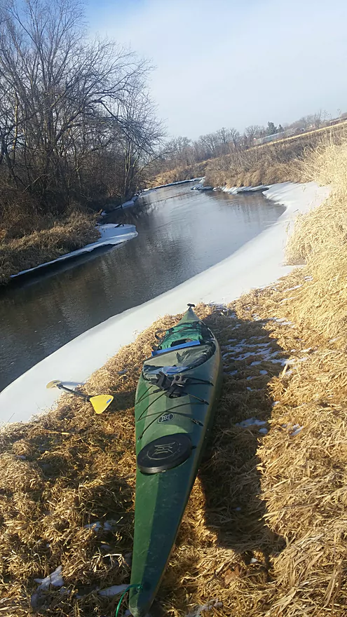
Olson Road Put-in
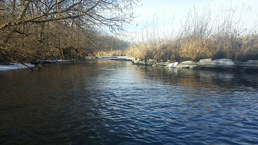
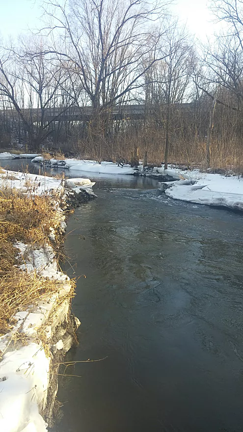
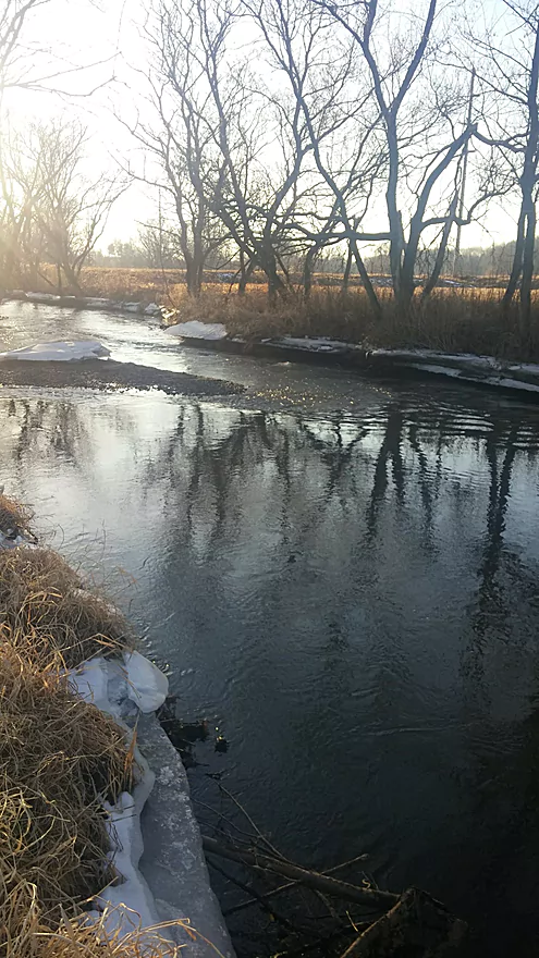
Ice Shelves
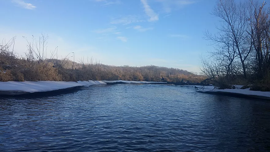
Clear blue skies, wide open views
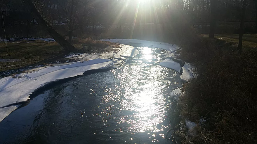
Sun light and ice sculptures
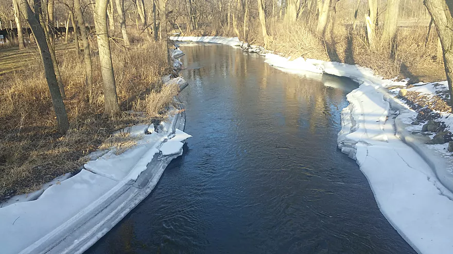
Ice shelves
Start of Wolf Run Trail
Riffles
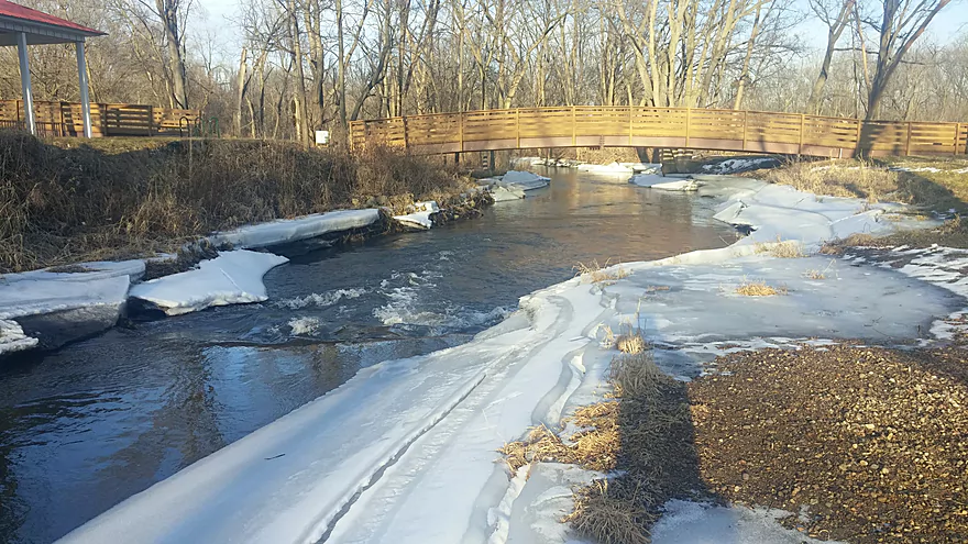
Bridge on The Wolf Run trail
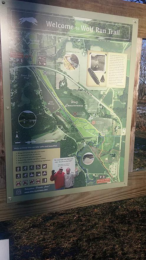
Wolf Run Trail Sign
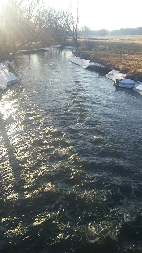
Riffles
Alternative Landing in Mazo
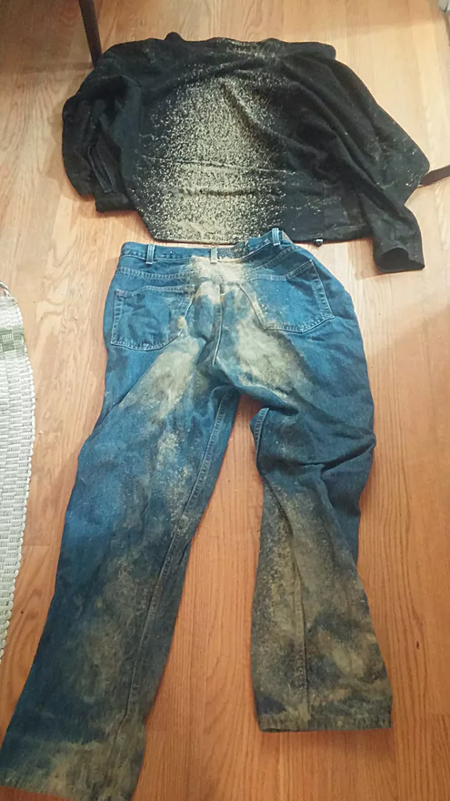
Muddy clothes from bike shuttle
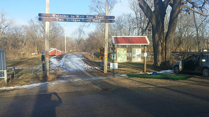
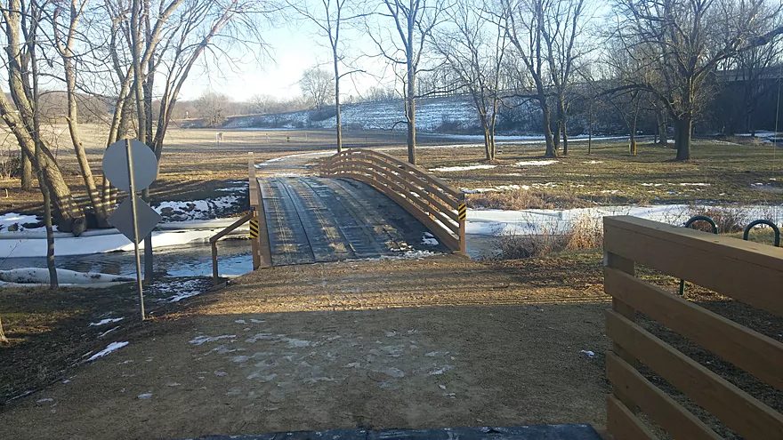
Wolf Run Trail Head parking lot
Black Earth Creek – Winter Paddle


Background:
This was my first foray into winter paddling so I wanted to try a short trip on a river that I was familiar with, was close by, and was easy to get off in case I got cold or wet. This section of the Black Earth Creek from Olson Road to the Wolf Run Trailhead in Mazomaine was perfect because it is short, safe, and there is a trail and/or road nearby for the whole trip. So if needed, it would be an easy and short jog back to my car or bike. Once I got on the water I wished I had planned for a longer trip as it was a delightfully serine and visually beautiful trip and thanks to temps pushing 50, clear blue sky, and lots of sun. With proper gear and clothing I was warm and toasty the entire trip.
This is a short section of the creek with several wing dams and ledges that were put in the creek bed to improve the oxygen level for trout. At higher levels these make for short fun rapids and drops, at lower levels they are a bit trickier as some of the rocks are exposed, and there are several shallow areas. This section has an especially nice 2.5 mile bike shuttle option using the Wolf Run Trail that runs mostly right along the river from its trail head on Crescent Street to its end at Wisconsin Heights High School, which is less than a ½ mile from the Olson Road put-in.
Gear:
The key to staying warm when paddling in winter is, in a word, neoprene. I had neoprene gloves, socks/ booties, neoprene pants and a “shorty” style neoprene wet suit, a full spray skirt, and a waterproof jacket. As I said I was very comfortably warm for the entire trip. My feet, hands and arms did get wet a few times during the trip due to the rapids and ledges and getting out of the boat to take pictures and go to the bathroom ( very difficult in a wetsuit… remember this if you like having a beer or two while paddling) but I was warm none-the-less. Neoprene clothing is not meant to keep you dry, it is meant to keep you warm even if you do get wet. For safety I also had a complete set of warm clothes with me in a dry bag, and another set in the car.
Overview:
The put-in was a bit tricky as there was a shelf of ice all along the bank, that did not look strong enough to stand on and was snow covered and slippery. In the end, I was able to knock a little “V” into the ice shelf with my paddle, and by setting the kayak in the V, I was able to just slide down the shelf into the creek. There were shelves of ice most of the way, which while making for some very beautiful natural ice sculptures, also made it difficult to find places to easily get out of the creek.
I had never run the creek when it was so low, and although there were many more shallow spots and exposed rocks, I never had to get out, and never completely bottomed out. There were a few more obstacles to avoid, and it was more necessary to read the river to stay in the deepest part of the river, but it was still very runnable. Because the river was so low many of the wing dams were clearly visible at or just below the water level
I have run this section several times before, but for some reason this time the trip seemed different, very quiet, peaceful and serene, very little road noise, no wind, not even much wildlife other than a few muskrats. Perhaps it was the beautifully sculpted ice shelves, or the bright white snow against the clear blue sky, or just being outside and on the water after the last cold snap, but it was an amazingly relaxing and enjoyable trip.
What I liked:
Easy and safe way to try winter kayaking, beautiful scenery, sunny and open landscape, an easy but muddy bike shuttle, and good small local restaurants in Mazo (Base Camp and Wall Street Bistro).
What I didn’t like:
The wet, sloppy, muddy bike shuttle…I mistakenly brought my mountain bike (no fenders) and got completely muddy and soaked to the bone, before I even got on the water (see photo) but fortunately I had an extra set of clothing in a dry bag in the kayak. Getting on and off the creek was tricky/slippery due to the ice shelfs, as was having to get out of and into a wetsuit to go to the bathroom (talk to a surfer sometime to hear their solution)
If I did it again:
I would go all the way to Walking Iron Park on the other side of Mazo and/or put in at the Shoe Box and I would use a bike with fenders, and maybe use a Stadium Pal (Google it)
The trip started at Olson Road bridge (a good access option).
The trip concluded at Crescent Street in Black Earth by the Wolf Run Trail access. This is a relatively new landing and a good access option for paddlers.
Class I rapids and some ledges. Skill level intermediate.
The trip was done at 45 CFS per the nearby gauge at Black Earth. This is a bit below the recommended levels, but by paying close attention to the river it is runnable without too much scraping bottom.
Thanks for the review Eric! The pictures look great and it sounds like you had an otherwise good time aside from the bike shuttle. A cool trick for winter paddles might be go right after a snowfall to get that “winter wonderland” effect before wind removes the snow from the trees.
The following is a list of Black Earth Creek trips segments previously done on this website.
Detailed Overview
- Upstream from N. Birch Trail: The creek is small, but might be surprisingly navigable during high water.
- N. Birch Trail to Stagecoach Rd: 0.5 miles. Creek here is small and wooded with possible congestion and a few jams.
- Stagecoach Rd to Cross Plains: 2.0 miles. An intriguing prospect that may now be viable because Black Earth Creek has grown in size. Starts narrow, rocky and wooded then opens up. Maybe 2-3 logjams. Stagecoach Rd may not be a good access as a "No Tresspassing" sign is on one side of the bridge.
- Cross Plains to Salmo Pond: 4.3 miles. Nice stretch. Half of this leg flows by the community of Cross Plains. One fence and one logjam to deal with but not major.
- Salmo Pond to Black Earth Community Park: 4.2 miles. Several fences to deal with, but all in all, one of the more underrated legs on the creek.
- Black Earth Community Park to Olson Road: 4.5 miles.
- Black Earth Community Park to The Shoe Box Landing: 1.5 miles. Nice stretch that passes through the outskirts of Black Earth. Might be a few minor logjams to sneak past.
- The Shoe Box Landing to Olson Road: 2.9 miles. Pleasant open stretch. This is a common "add-on" leg for those wanting to do the popular Mazo trip, but as a longer trip.
- Olson Road to Walking Iron Park: 3.7 miles. The best and most popular leg on the creek. Much of it flows around the outskirts of Mazomanie and though a nice woods.
- Walking Iron Park to W. Hudson Road: 1.1 miles. A small but great section that is recommended as an add-on to an Olson Road trip. This doesn't receive as much upkeep so paddlers may encounter a logjam or two.
- W. Hudson Road to Blynn Road: 4.4 miles. An ok section but nothing special. This leg while once clear, may now have a few surprise logjams.
- Blynn Road to Mouth at Arena: 6.8 miles. Technically now Blue Mounds Creek, this is the weakest section.
Trip Map
Overview Map
Photos Size:
Just did this section on 10/18, no jams or obstructions until the very end, at the rapids just after the Hwy 14 bridge and upstream from the Wolf Run Trail bridge, a few trees down, but passable on the far left side and the landing at the trail head is washed out but still serviceable.
That’s great news as previously it was noted there were more serious jams on this stretch. Wonder if the locals cleaned them out.
There is a strainer on the Olsen Rd to Walking Iron section immediately after passing under the Highway 14 bridge when entering Mazomanie. On approach it looks like you can skirt around the edge but the main current will pull you into and under the log jam.
Recommend portaging.
There is one other log jam in Mazo in calm water that is easier to portage around.
Appreciate the update Aaron.
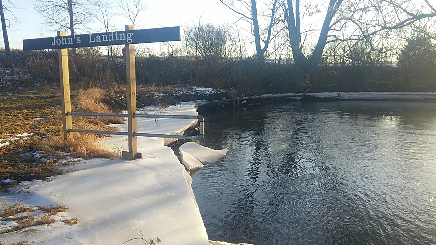
We did the trip from Olson Rd to Walking Iron (John’s Landing), and it went so beautifully that we decided to move one of our shuttle cars 1/4 mile down to Hudson Road, and continue our trip another mile or so down the river. About 100 yards after John’s Landing there is a tree down all the way across at water level. It looked possible to hop over it on the far right side right next to the bank, but the current was very swift and pinned one of our party against the tree, and then she tipped and went under. Thankfully it was open water under the log, and she got out safely, but her kayak got pinned nose first, rear sticking up, under the tree. It was a team effort to get the kayak pushed all the way under the log to the other side. As I said, thankfully the water was open under the tree, but it could easily not remain that way and become a dangerous strainer. This tree will need some chainsaw work I’m afraid, it’s a good 12-18″ diameter.
Great to hear that you had a good trip upstream from Walking Iron. It is too bad to hear about the logjam west of town though which sounds pretty serious. You definitely don’t want to mess with any logjams that are combined with swift water. Hopefully it gets cleared out in the future.