
Blue River
This is one of the best kept paddling secrets of Southwest Wisconsin. While never very big, the Blue River flows by some super scenic driftless bluffs.
Trip Reports
Bluff Road to Bowers Road
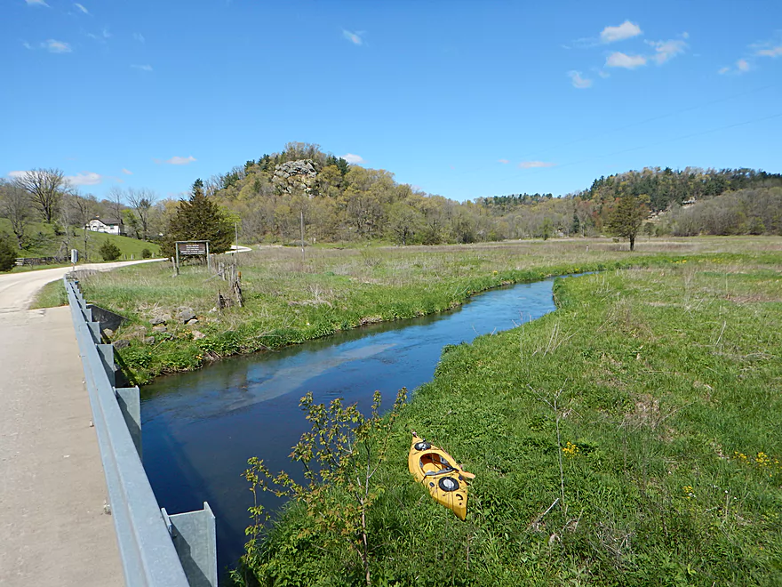
Date Paddled: May 6th, 2017
Distance: 4.1 Miles
Time: 2 hours 46 minutes
A spectacular paddling prospect hidden in the driftless area of southwest Wisconsin. Fun rapids, hidden valleys, boulders, and occasional outcrops make this the favorite paddle to date for 2017.
Read More...Bowers Road to Shemak Road
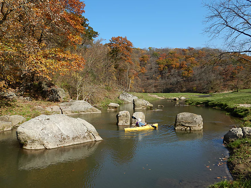
Date Paddled: October 21st, 2017
Distance: 6.6 miles
Time: 5 hours (3 hours is more typical)
A paddle through a narrow, hidden valley features blufftop outcrops, relict pines, giant boulders, and classic driftless scenery. The best trip of 2017 and one of the best paddles in Southern Wisconsin.
Read More...Hwy G to Forest Road
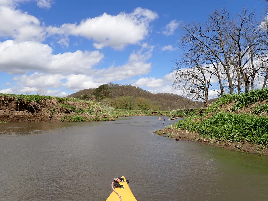
Date Paddled: April 27th, 2024
Distance: 8.0 miles
Time: Expect 4 hours
Aside from a few logjams, this is a pleasant and open stretch of the Lower Blue River (located in Southwest Wisconsin).
Read More...Overview Map
Detailed Overview
Blue River – Main Branch:
- Upstream of Blue River Road: Likely not practical for paddling.
- Blue River Road → County Road I: 1.4 miles. Mostly clear of logjams, but shallow and would require high water to be navigable.
- County Road I → Bluff Road: 0.9 miles. Nice section that goes through a small woods. Maybe 1 or 2 jams. In hindsight, I wish I had done this. A shallow section but looked just doable when I scouted it during my first trip.
- Bluff Road → Bowers Road: 4.1 miles. Five star trip.
- Bluff Road → Snowbottom Road: 2.4 miles. Fantastic section through driftless valleys with many light rapids.
- Snowbottom Road → Bowers Road: 1.6 miles. A good section through a small woods, then through an open area reminding me of the Platte River.
- Bowers Road → Shemak Road: 6.6 miles. One of the best paddles in Southern Wisconsin with massive boulders, fun rapids and scenic driftless hills.
- Shemak Road → Biba Road: 1.7 miles. Mostly open farm country paddle. Maybe 2 logjams.
- Biba Road → Hwy G: 5.0 miles. Maybe 15-20 logjams.
- Hwy G → Forest Road: 8.0 miles.
- Hwy G → Studnika Road: 1.0 miles. Nice open stretch with an attractive bluff. There are two noteworthy logjams, with one needing a portage. Castle Rock Creek adds significant volume to the Blue River. Note Studnika Road is not a suitable access.
- Studnika Road → Forest Road: 6.7 miles. Nice leg through open pasture and bluffs. There are a couple of downed trees, but I was able to sneak past them without portaging.
- Forest Road → Hwy 133: 6.3 miles. Maybe 3 logjams. The river is wide enough here you might be able to squeak past most of these. Hwy 133 is a busy road with long guardrails, which would make this take-out annoying, but I think it should be doable from the SE side.
- Hwy 133 → Wisconsin River: 1.0 miles. Maybe 6 logjams. This is floodplain forest now.
- Wisconsin River – Cross Slough: From here you can paddle a mile north to reach the Port Andrews Boat Landing. Alternatively, you can paddle down Cross Slough for 3 miles which is like a mini-river and might be a unique paddling experience.
—
Castle Rock Creek (aka Blue River – Fennimore Branch):
- Upstream of Hwy Q1st: The creek is probably too small to run.
- Hwy Q1st → Homer Road: 0.5 miles. Very small. A simple cow pasture paddle that probably isn’t special. Homer Road is not a great take-out…small, near a home, and a nasty pit bull chased me when I tried to scout this bridge.
- Homer Road → Hwy Q2nd: 0.3 miles. Simple open section through overgrazed and eroded banks. The second Hwy Q bridge is a decent access used by fishermen, but there is nowhere to park.
- Hwy Q2nd → Church Road: 0.4 miles. Paddle goes by a steep hillside and quarry. Maybe some interesting geology.
- Church Road → Hwy Q5th: 3.1 miles.
- Church Road → Hwy Q3rd: 1.2 miles. A nice open pasture section with many riffles, but one I-beam to portage.
- Hwy Q3rd → Hwy Q4th: 1.1 miles. A neat section with many rapids that goes by Cedar Cliff.
- Hwy Q4th → Hwy Q5th: 0.7 miles. Shallowest part of the creek during low water. Some neat geology in this section with more great rapids and a spectacular view of Castle Rock. Hwy Q5th is a doable take-out but does require some dragging to get past the guardrails. Many hikers park by the bridge before climbing Castle Rock.
- Hwy Q5th → Witek Road: 7.3 miles. River flows through a massive hidden valley flanked by steep hillsides. Includes the western unit of Snow Bottom State Natural Area. While mostly open, the river does have three logjams that must be portaged. After Snow Bottom, the river loses most woods, gains a lot of mud, and flows through farm country.
- Witek Road → Neff Road: 3.9 miles. A farm pasture paddle with likely a number of downed trees (maybe 7 portages).
- Neff Road → Hwy M: 1.9 miles. Mostly open farm pasture paddle. Maybe one logjam.
- Hwy M → Confluence with Blue River: 3.8 miles. Maybe 3-5 logjams.
Nearby Guages
Videos
Comments
Appreciate the update!
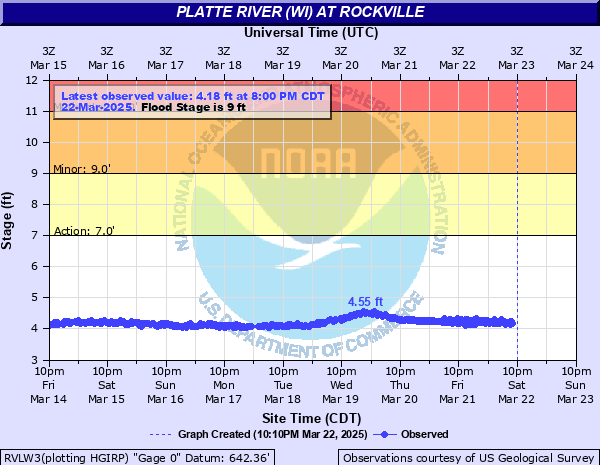
Just did this with 4.68 ft 220 cfs on the Platte River Rockville gauge. A little bumpy, but very doable. There was one tree down that required portaging and one barbed wire that was a little low to paddle under. A couple other wires/ribbons too but visible and easy to paddle under. Great trip!
Thanks Charlie for the feedback. Some of those fences yes might be new which is too bad. The upper blue truly is a hidden gem, but can only be done in highish water.
I paddled this portion today (6/13/24) and it was definitly a beautiful area to see. The riffles, bluffs, and fields were a treat. Since the trees were fully leafed out the wooded areas had an almost fantasy feel to them, particularly in one area with boulders in the river and pools made on the sides.
The CFS for the Platte is about the same today as when you went - 184. However, I spent a lot of time shimmying myself free from rocks and shallow spots. I'm not an experienced river reader, so perhaps I just kept taking the worst routes, but I think a higher river would have made for a more smooth ride for me.
The first gate fence is so bogged down with debris now that I was able to pop over top of it, but all the others I had to portage. The barbed wire one I didn't have anything to help lift it up high enough. There was another one that nobody has mentioned, so perhaps it is new. The fence up on the hill leading down to it certainly looked pretty recent. It was too high on the river to get over and the banks didn't have a great spot to portage (maybe the left side was better, but I went with the right). I had to pop the kayak over and have it beach itself by a log, and then climb over a boulder which had barbed wire bolted into it. Made for quite the adventure!
There are certainly times, particularly in the first half, when you could fool yourself into thinking you are far away from any civilization and experiencing the world as it was. Thanks for the guide!
Yeah, logjams on the lower Blue are major issue unfortunately.
For those trying to paddle the Blue River from these upper areas to it's mouth, you will have problems with "log jams" in the lower areas plus it does not end on the Wisconsin River but flows into a slough where, if the water is high enough, you can paddle to the Wisconsin River. I've tried paddling up the Blue to the Wisconsin highway 133 bridge but the log jams are not passable unless one exits their boat on a log then pull the boat over the logs. The bank is too high so it's not possible to exit ones boat to go around the logs.
Thanks for the update.
Did the blue river yesterday (8/29) and a 172 CFS. Was sufficient probably 70 percent of the way but there was stretches that were leaving me wanting higher water levels. Other than a few cows later in the trip, one tree that was down (easy paddle to the side or under) crystal clear water and great weather. No fences, just 4 ribbons across the river that are high up and easy to get under.
Appreciate the updates. It does appear paddlers do prefer high flow rates when it comes to Snow Bottom. If you could share your pictures that would be great! Maybe upload them to an online service and I could insert the urls into your comment?
I just paddled the Blue River with a group of 24 on June 21, 2019. We put in at Snow Bottom Road which has an adequate parking lot. We put in just below the bridge. We took out at Shemak Road for a trip of 8.2 miles which took us about 4.5 hours to complete. The Platte River gauge was 320 CFS. Comparing the original post of 117 vs ours of 320 may not provide a reliable water gauge level for the Blue River. The water depth was adequate for this paddle, however I would not care to do it at a lower level. An additional 3 inches would have been ideal. We had one logjam to portage, cleared out a couple of other trees and had a couple of limbo trees. Overall we had a great time on this paddle. Wild Parsnip is everywhere, avoid this plant! I could submit a couple of photos for reference as well.
Thanks Jon for the update. I definitely think my 250 max estimate before was too low and will update my estimates with a reference to your summary.
Paddled Bluff Rd. to Shemak on 25May2019 (Aaron, feel free to add these comments to your Bowers to Shemak section if you like). Platte gauge was at 450 CFS @5.3 ft. We put in on the opposite bank from Aaron's photo because we saw the fishery access sign on that bank.
Lots of debris was weighing down the old cattle gates. Until debris is removed, most paddlers would portage the gates, at least at these water levels. Some barbed wire was also weighed down with debris. We brought y-shaped lifting devices to help us sneak under (collapsible hot dog fork with a plastic handle for me, custom-made PVC "y-er" for companions). A few logjams, (mostly downstream from Bowers Rd.) One portage had lots of nettles, but I was wearing long pants.
There was a fresh skin of mud along many stretches due to the river being higher the day before. This made the take-out at Shemak and some of the portages a bit slippery.
We'd been hoping to catch the Blue with enough water in it, and the beautiful scenery and made it worth the portaging and fence lifting.
Aaron, you might want to update your CFS guide (quoted below) to reflect our experience. We're by no means advanced whitewater paddlers. Backferrying and river reading skills help, but one of us was in a 12' Tribute (sporty rec boat with a keel). Shorter boats with more rocker help on most twisty/riffly streams. The Blue is seldom more than waist deep, so wading a boat to shore after tipping/swamping should be doable for many paddlers. (Yes, one of us hit a tree and swamped.)
Aaron wrote: "251+ CFS: I assume these are near or at bank breaching levels. Maybe of interest for professional whitewater paddlers but for few others."
As always, assess the risks and conditions to make sure your skills and boat are suited for your trip.
Appreciate the feedback Matt. The Blue River is one of my favorites...that one hill on the bike shuttle is pretty brutal though.
Just found the website this year and this was my first paddle using your guides. CFS was 162 which was pretty good but we scrapped the bottom a little bit in the rapids. No portages were required. Had an amazing trip, the bike shuttle was fine except for one hill that we walked. Thanks for the guide.
Appreciate the comment! More of the Blue River actually might be navigable...might try to explore the headwaters next spring. If you do Snow Bottom, consider leaving a comment letting readers know the latest conditions of this stretch.
After doing the stretch upstream, which was way cool, I can't wait to do this one. Thanks for the great pics!
Thanks for the comment and the heads up about my typo. Not sure how I missed that...
Hello! Thanks for bringing this wonderful waterway to my attention. We ran it today. Platte levels were @ 155 & we found that to be OK--no dragging, but a few bumps. Big deal. Can't wait to do another stretch. One small item--at the top of the post, it states the takeout to be Snow Bottom Road, should be Bowers Road. Love the pictures & video--very enticing! Thanks!!
How did your trip turn out? Questions or comments? Feel free to leave your feedback.
SUBMIT COMMENT!
Be notified when future paddle reviews go live by subscribing!
