
Waupaca River
This is one of the great paddling rivers of central Wiconsin. Highlights include scenic boulder gardens and fun (mostly) safe rapids.
Trip Reports
Hwy 161 to Amherst Dam
Date Paddled: September 14th, 2013
Distance: 6 Miles
Time: 3 hours 20 minutes
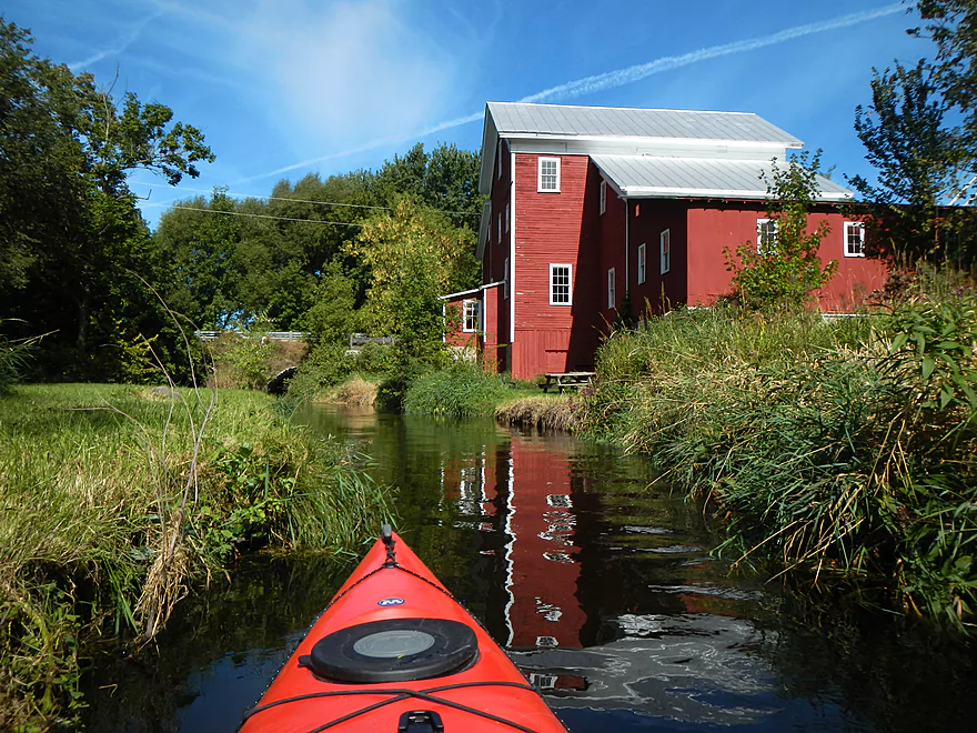
A tributary to the Wolf River, this is a very nice river/stream that is often overlooked because of its popular neighbors (Little Wolf/Waupaca/Crystal/Wolf/Plover). The Tomorrow never gets very big before it gets to Amherst and “magically” turns into the Waupaca River (an oddity, as Rivers don’t usually change names like this). Despite this being September […]
Read More...Mill Street in Amherst to Otto Road
Date Paddled: August 26th, 2018
Distance: 7.0 miles
Time: 6 hours 23 minutes (3.5 hours would be more typical)
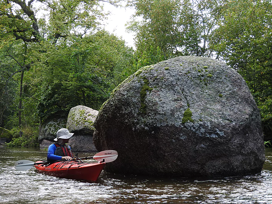
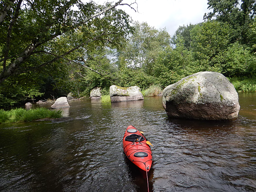
One of Central Wisconsin's finest paddles with plentiful rapids and clear water. The highlights are the boulder gardens which are among the best in the state.
Read More...Buchholz Road to Stedman Park
Date Paddled: August 13th, 2016
Distance: 6.0 Miles
Time: 4 hours 54 minutes
An overlooked section of the Waupaca that offers amazing scenery, gorgeous boulder gardens and fun rapids.
Read More...Stedman Park to Durant Road
Date Paddled: October 18th, 2025
Distance: 2.2 miles
Time: Expect 1 hour
While not exactly the most popular or best leg on the Waupaca, this was still a nice trip with attractive rocky woods and calendar-quality scenery.
Read More...Hwy Q Canoe Launch to Brainard's Bridge Park
Date Paddled: July 13th, 2014
Distance: 7.8 Miles
Time: 5 hours 14 minutes
A classic water trail in central Wisconsin, the Waupaca River is a great prospect with striking boulder gardens, great water quality, and fun/safe riffles. The river starts close to the city of Stevens Point and winds east before emptying into the Wolf River. I’ve actually paddled the Waupaca before…well, kind of. Last fall, I paddled […]
Read More...Overview Map
Detailed Overview
- Clementson Road to Hwy Q: 0.9 miles. Possible prospect, but the river is very small here.
- Hwy Q/Rolling Hills Road to Hwy 161: 1.2 miles. A good prospect.
- Hwy 161 to Amherst Dam: 5.4 miles. More of an oversized creek than a river, the Tomorrow River is still a nice paddle known for its clear water.


- Hwy 161 to 1st Street: 1.3 miles. Great trip.
- 1st Street to the Amherst Dam: 4.1 miles. Great put-in and trip.
- Hwy 161 to 1st Street:
- Amherst Dam to Buchholz Road: 5.7 miles. This section was great fun because of its many rapids, clear water, narrow channel, boulder gardens and wooded banks.
- Amherst Dam to Hwy A: 1.7 miles. Great segment through Amherst.
- Hwy A to Keener Road: 0.6 miles. A short but good section with a nice boulder garden.
- Keener Road to Buchholz Road: 3.4 miles. Aside from some Class 2 rapids at Keener Road and a few boulders, this is a more open and less interesting section.
- Amherst Dam to Hwy A:
- Buchholz Road to Stedman Park: 6.1 miles. A fantastic paddle that was narrow, fast, rocky, and scenic.
- Buchholz Road to Otto Road: 1.5 miles. Great stretch with some huge boulder gardens.
- Otto Road to Hwy T: 0.9 miles. Another great section with some boulder gardens and light rapids.
- Hwy T to Stedman Park: 3.7 miles. Good stretch with some great rapids and boulder gardens at the end.
- Buchholz Road to Otto Road:
- Stedman Park to Durant Road: 2.1 miles. A really nice leg. Starts with some terrific boulder gardens, rapids and pine stands by Stedman Park. River then flattens out for the middle portion and becomes a bit less interesting. The final leg features some terrific pine stands.

- Durant Road to Cobbtown Road: 1.4 miles. A nice section, but not as good as upstream parts with less boulder gardens and rapids. Maybe one logjam.
- Cobbtown Road to Frost Valley Road Access: 1.7 miles. Starts nice with fun rapids and a decent boulder garden. But satellite images suggests 3-5 logjams that might require portaging.
- Frost Valley Road Access to County Q Canoe Landing: 2.0 miles. Satellite images suggest a number of logjams (maybe 8). I would wait for this stretch to get cleared out before attempting.
- Hwy Q Launch to Brainard's Bridge Park: 7.8 miles. A great trip that is very popular with paddlers.
- Brainard's Park to Elm Street Dam: 0.8 miles. Half of this is a nice river paddle, half a boring flowage. There is a portage path around the dam.
- Elm Street Dam to Kiwanis Park: 3.3 miles. Great prospect, but perhaps a logjam or two. The Mill Street dam is VERY dangerous and preceded by Class 2 rapids. This is also a difficult portage. Scout before committing to a trip.
- Kiwanis Park to Harrington Road: 7.7 miles. A good prospect.
- Harrington Road to Weyauwega Dam: 4.4 miles. Maybe 3 miles is open flowage paddling.
- Weyauwega Dam to Decker Memorial Park (and the Wolf River): 6.2 miles. A mediocre prospect.
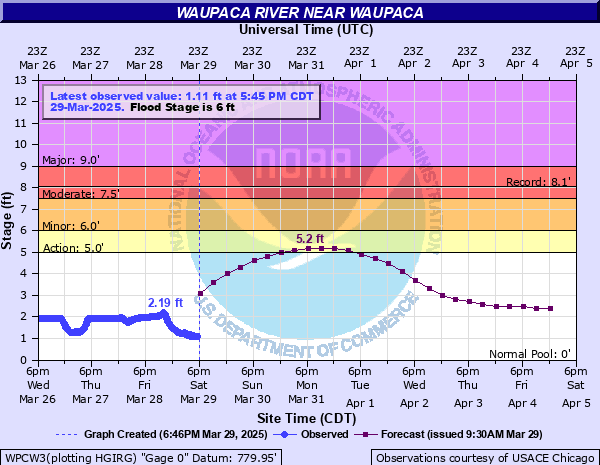
Nearby Guages
Videos
Note, the videos are out of order and from two cameras.