
Rocky Run Creek
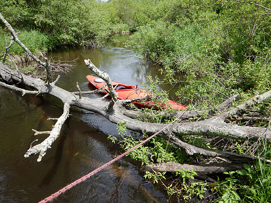
This is a small tributary of the Wisconsin River located south of Portage. Logjams and low hanging alders can be a challenge for paddlers though.
Trip Reports
Dunning Road to Hwy 51
Date Paddled: March 13th, 2021
Distance: 4.2 miles
Time: Expect 2 hours
A nice creek, but logjams and low-hanging alder branches were a bit much
Read More...Hwy 51 to Dekorra Public Landing
Date Paddled: May 29th, 2016
Distance: 4.43 Miles
Time: 2 hours 37 minutes
Kind of a disappointing trip because of the log jams. This trail does have redeeming qualities if you do the right leg and paddle at proper flow rates.
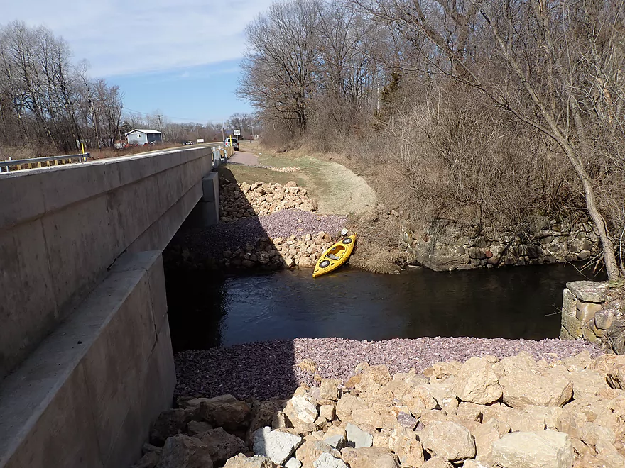
Read More...County V Bridge to Private Residence
Date Paddled: June 2nd, 2013
Distance: 5.1 Miles
Time:
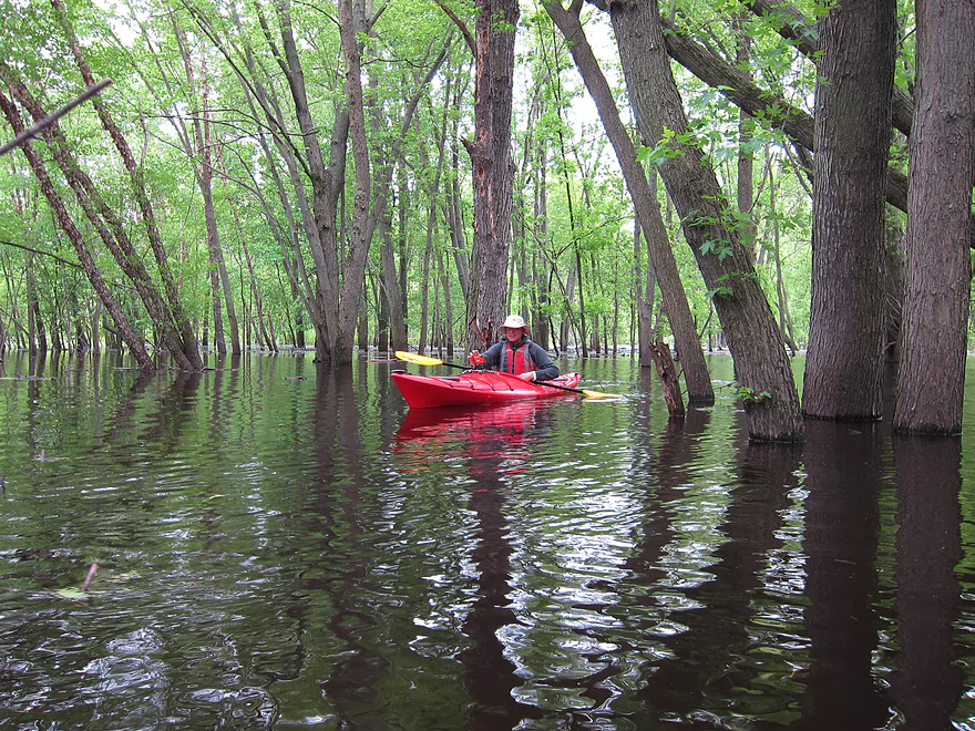
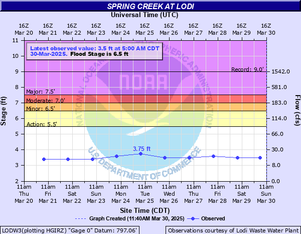
This was a segment run during very high flood water (4.6 feet down by Muscoda and 11 feet up by Wisconsin Dells per USGS). Normally, this would be a bad thing to do on the Wisconsin River, as the high water covers up the sandbars, but in this case the high water was actually a […]
Read More...Overview Map
Detailed Overview
- Traut Road to Cuff Road: (2.6 miles) Surprisingly open and clear of most deadfall, this is a simple wet-grass prospect but very small and would require above average conditions to be feasible. An intriguing prospect.
- Cuff Road to Dunning Road: (3.1 miles) Deadfall appears to be too much of an issue for this leg.
- Dunning Road to Hwy 51: (3.9 miles) Swift current, gravel, and an attractive marsh are highlights. Unfortunately logjams and low hanging alders are a bit much.
- Hwy 51 to Hwy J: (2.5 miles) An ok section but with several muddy portages.
- Hwy J to Dekorra Landing: (2.0 miles) This section has too many jams to be enjoyable. But during high water you can go over these and through the silver maple forest which is an amazing experience.
- Additional Wisconsin River Options: For other take-outs and adventures on the Wisconsin, see my Wisconsin River overview map.
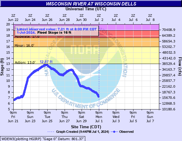
Nearby Guages
Videos
Comments
Thanks for the update and warning.
Went from Hwy 51 to Dekorra landing today. Lots of recent rain. Branches hanging down and impeding paddling every 50 yards. As we put in a local resident stopped and asked if we had a saw. The hardest challenge was the rebuilt foot bridge (now an ATV bridge) that is too low to go under and very hard to portage. About mile 2. After that the going was much better. We spooked 7 deer and 2 turkeys. A trip only for hardy paddlers.
Update on the logjam situation from Karen. "There was a tree down where we wanted to put in by Hy51 but we were starting so late in the afternoon, so we changed our put in to J/V. There were trees down not far from the J/V bridge, but our kayaks moved around them easily. We never had to climb over or portage around anything. We do carry a small handsaw with us just in case, but we were able to maneuver in kayaks."
I wonder if the Wisconsin backfilling the the lower portion of the creek covered up some the jams. Yeah that section is really cool when flooded...another similar flood paddle would be to the north by the power plant and on Duck Creek. But I've heard getting lost can be an issue.
I ran the section from the hwy 51 Bridge to the second Dekorra landing (behind Hookers resort)with A bike shuttle. There was plenty of water and just a few obstructions. most of them simple. I had to get out of my boat a couple of times and out of the river once, the rest I was able to squeeze over, under or through. Fairly clear water and nice sandy bottom in many places. There was a foot bridge that was in the process of being built, unfortunately it is being built at the worst possible height, to low to get under yet high enough to require you get out of your and go to shore to get over it. On the upside the river is not very deep and there is not much current, so it is not hard, just a hassle. The Wisc was high so there were a lot of cool exploring possibilities in the flood plan forests. Felt very Bayou like, almost expected to see an alligator. The bike shuttle was a short 3.3 miles (15 mins) fairly level and a nice country road except for the last 200 yards or so which is on Hwy 51, but it has a nice wide shoulder, and is down hill so it only takes a minute or 2 to bike it.
I'm not aware of any specific rules. Generally speaking it is quite common for paddlers and liveries to remove logjams.
What are the rules about cleaning out a public waterway? Can anyone try to cut out deadfall?
I appreciate the comments. Yeah, I do wish somebody would tidy up the creek, but it is doable now for adventurous paddlers.
Have now done Rocky Run twice. Thanks for your pictures and advice. First time in June 2018 from J/V bridge up to Hwy 51 and back. So much fun. Today, from 51 all the way to river. 2 trees and 1 bridge to portage in the 51 to J/V bridge section. That section was lovely and took about 1 hour. I could have stopped there. I agree I also should have just gotten out at J/V Bridge and launched 500 ft down the way to avoid 4 more portages, but kind of proud I could do them. I just moved in to the area and wanted to really explore. I took out an 8 ft kayak with a good rope, so the portages went well. Really is beautiful. No bugs, ticks, or deep mud for me on either trip,but, have to be willing to portage. I will do the 51 to J/V bridge again when the trees turn color, but I am done with that first 2000 ft of creek after the bridge for now. So wish someone could get in there with a chainsaw but that is above my pay grade. I am a 58 year old, 5 ft 3 in female, with low center of gravity, so popping in and out of a kayak and over a few trees isn't that big a deal. Nice change from the Wisconsin.
Thanks Bob for the tips. It is too bad about the lower section.
As far as Dunning to Hwy 51...appreciate the tip! I scouted this and it did look nice. Will have to check it out sometime.
I live at that entry point. I am amazed at how many people try this paddle. Years ago my son and I did it twice at the same time....First and Last. It is a miserable route...in low water one must literally pull yourself through mud and not more than inches of flowing water below VJ bridge...nettles galore if you portage...just today I suggested to a group of five with one canoe that they should reconsider as two of the five were small kids. A more interesting trip is from the next road east which is dunning to the bridge over hwy. 51...winding through aldershot and open but many oxbow bit it has been cleared out and is smooth paddling
Thanks Jon for the update and sorry for the delay in getting back to you. Hopefully the locals will eventually clear out this creek.
Paddled Rocky Run from 51 to Dekorra on Oct. 16, 2016. Even more log jams and very muddy portages than you reported. Fun and scenic in between jams, though. At high water levels you might have fewer portages.
How did your trip turn out? Questions or comments? Feel free to leave your feedback.
SUBMIT COMMENT!
Be notified when future paddle reviews go live by subscribing!
