
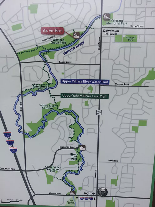
Map of the Upper Yahara
Yahara River – Deforest

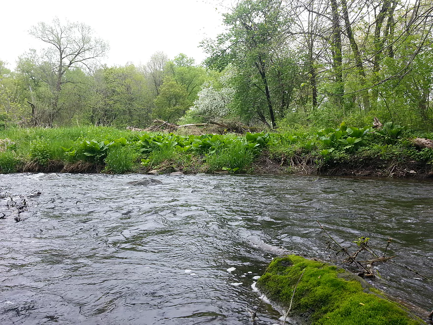
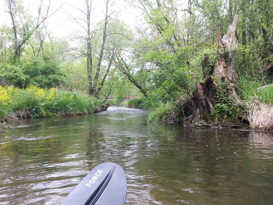
I will be looking to visit this section of river near my home any time there is enough rain. I did it at 1.3 feet and wouldn’t go any lower.
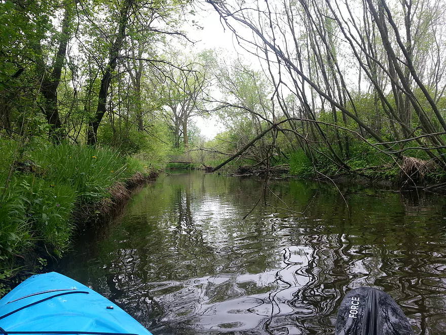
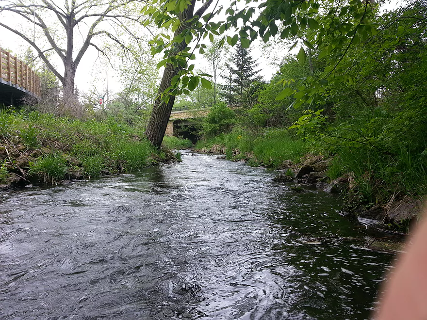
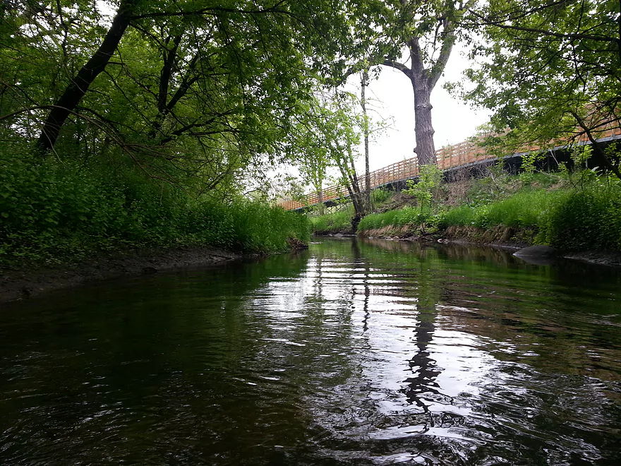
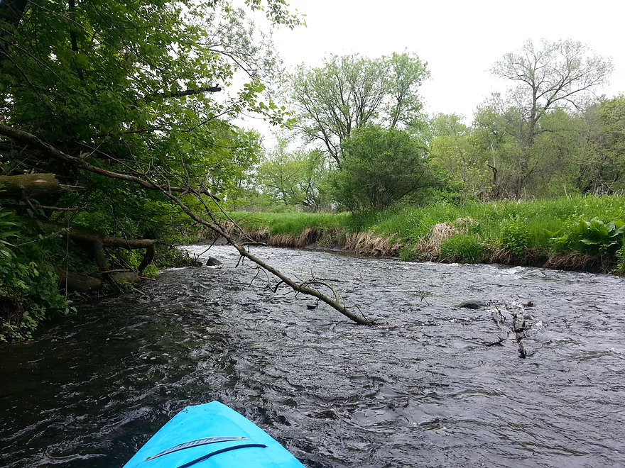
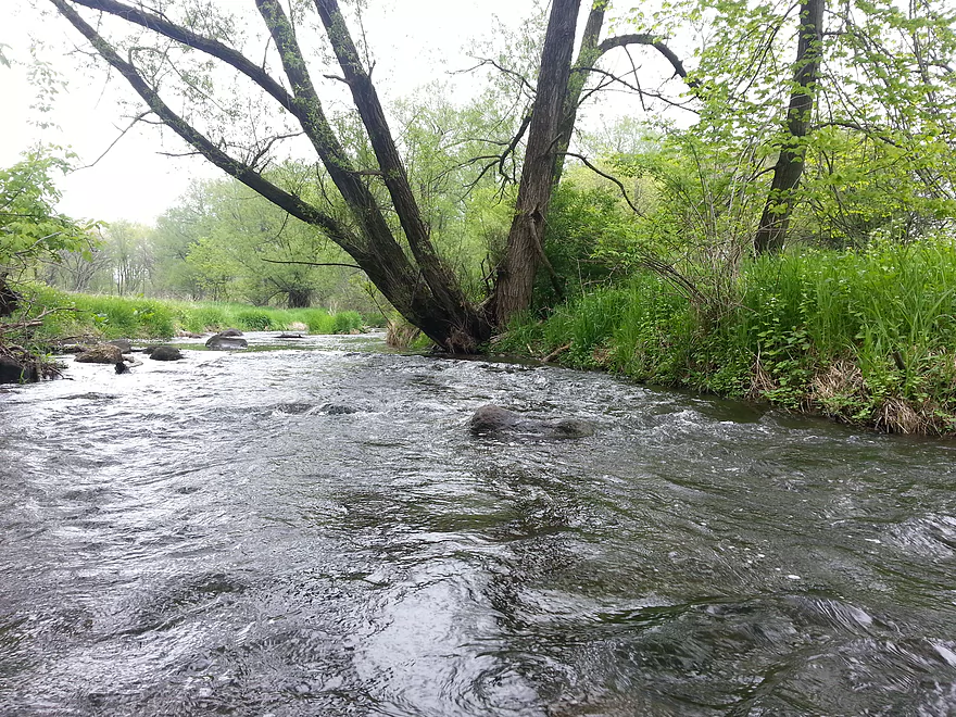
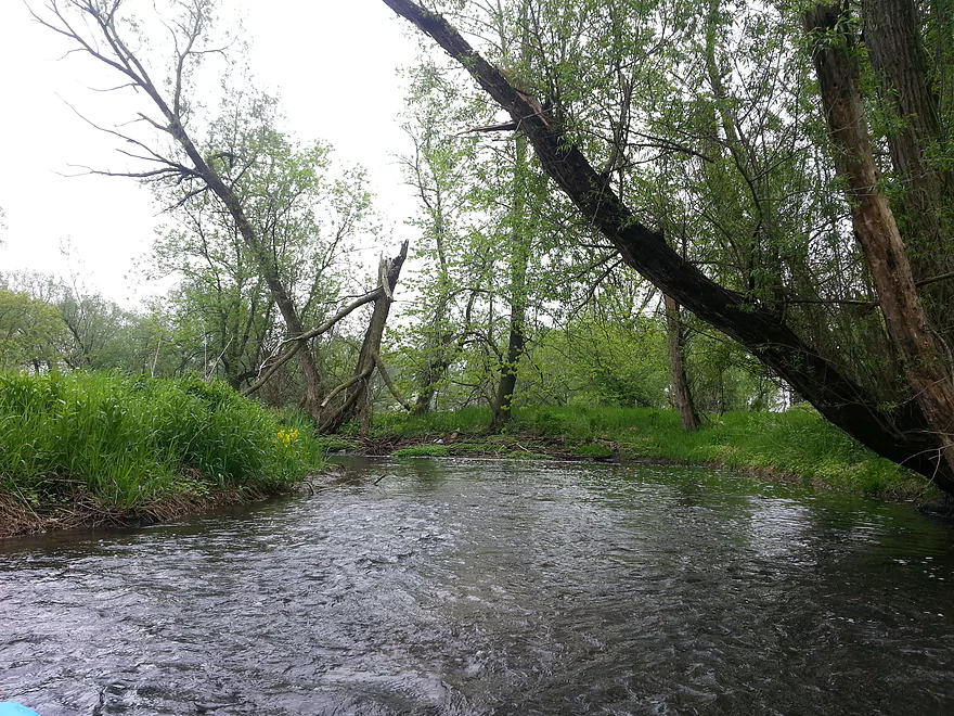
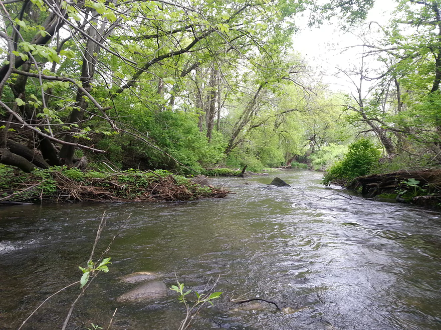
I don’t like long straight paddles — I like curves, steering between rocks, and reading the river to avoid shallow spots. This was great fun with no danger of falling out. I got hung up a couple times, but it felt like a video game where there are rewards and punishments for picking the right or wrong course. Fortunately, I have a short kayak that I don’t mind scraping on rocks.
I don’t think you could do an out-and-back run on this trip, with the way the current accelerates you downriver at times. Fortunately, the Upper Yahara River Trail makes doing a bike shuttle a really attractive proposition. This 4-mile bike trail goes all the way from the last take-out at Sunfish Pond to the first put-in at Veterans Memorial Park, traveling through hill, meadow, and forest on asphalt and raised boardwalks. You get a neat preview of some of the burbling mini-rapids that await you on the river.
The bike trail doesn’t have signage to guide you to the put-in, but I think you’ll be OK if you turn right every time: at the two T-intersections, and where the trail comes out onto Sunnybrook Drive. There, the river goes under the South Street bridge but the boardwalk doesn’t, so you briefly come out onto the street and turn right in order to cross the bridge. You then pick up the trail on the other side of the river.
The water trail is maintained by Friends of the Yahara River. I never had to portage. There are signs ahead of each takeout to notify you that it’s coming up. The takeouts are plain grassy banks in four city parks, all about a half a block’s carry from the parking area. After the last takeout, a sign warns “Maintained trail ends — golf course ahead.” I drove through the golf course but didn’t get out to see if it was navigable. It might be.
You see some parkgoers and well-groomed back yards, but you’re often surrounded by nature. My experience in the springtime included a good deal of wildlife: groups of 2, 3, and 4 deer; a raccoon at the riverside locking eyes with me the whole while I passed by; a crane, swifts, and a tree full of crows; and two duckling families with their usual peeping and fleeing. (Swimming and running don’t seem too different for a duckling; I saw one run up on a branch and back into the water, continuing the same foot-paddling motion the whole way like he was trying to run on the surface and sinking.)
I will choose to paddle here over the more sedate Token Creek whenever the water level gives me the opportunity. Too bad I can’t schedule rain for when I have visitors.
Webmaster’s Update: As of 2024 July 7th, reader Joey says there are many logjams on this stretch. Paddling this stretch isn’t recommended until they are cleared out.
Thank you to Karl Kovaciny for submitting the review! The section sounds great and I (and presumably my readers) look forward to paddling the upper Yahara. Note, WisconsinRiverTrips.com does indeed accept guest water trail reviews which are very much welcome. There is a formal trip review submission form here. But if that is intimidating, you can just send me (Aaron) an email and we can work out the details.
Detailed Overview
- Hwy 51 to E. Yahara Road: 1.4 miles. Very small and channelized, it seems open but there might be some snags here.
- Yahara Road to Veterans Park (DeForest): 1.6 miles. Very wooded so good chance of jams if not cleared out.
- Veterans Park to Windsor Road/Sunfish Pond: 5.7 miles. A small but fast stretch that has become popular in recent years.
- Windsor Road to Linden Drive/I90: 1.5 miles. An interesting section through a golf course. Linden Drive access is privately owned by the golf course.
- Linden Drive to Hwy 19: 1.3 miles. There are too many logjams to recommend this.
- Hwy 19 to Cherokee Park: 4.5 miles including 1.8 miles of lake paddling. There are too many logjams downstream of Hwy 19 to recommend that as a put-in.
- Cherokee Park to Tenney Park (aka Lake Mendota): 7.6 miles. A nice lake but really too big and exposed for most paddlers.
- Tenney Canal and Locks to Morrison Park: 1.3 miles. A fun experience. A canal fee might be required.
- Morrison Park to Paunack Park (Lake Monona): 2.6 miles. Mostly too big and busy to paddle, paddlers still do so and enjoy scenic vistas of the downtown.
- Paunack Park to Babcock Park (Lake Waubesa): 4.2 miles. Probably too much flatwater to be interesting.
- Babcock Park to Fish Camp Park (Mud Lake): 4.1 miles. Wide and flat. Probably uninteresting.
- Fish Camp Road to La Follette Park (Lake Kegonsa): 2.4 miles. Probably uninteresting lake paddling.
- La Follette Park to Viking County Park: 3.5 miles. Finally back to river paddling! An ok prospect, but slow and big.
- Viking County Park to Dunkirk/Hwy N1st Bridge: 5.2 miles.
- Viking County Park to Riverside Drive Park (Stoughton): 2.1 miles. A flowage paddle through downtown Stoughton.
- Riverside Drive Park to the Dunkirk Dam: 3.1 miles. A small flowage that is ok but nothing special.
- Dunkirk/Hwy N1st Bridge to W. Stebbinsville Rd: 4.8 miles.
- Dunkirk to Hwy N2nd Bridge: 2.5 miles. A good stretch that starts a bit slow, but speeds up and contains a number of large scenic boulder gardens.
- Hwy N2nd Bridge to W. Stebbinsville Rd: 2.3 miles. A scenic rocky stretch flowing through glacial outwash.
- Stebbinsville Rd to Murwin Park: 6.2 miles.
- Stebbinsville Rd to Hwy 59: 2.1 miles. This is the last super stretch of the Lower Yahara. After Badfish Creek joins up, the river becomes much larger and less interesting.
- Hwy 59 to Murwin Park: 4.4 miles. While not as scenic as upstream legs, this is still a solid stretch and popular with paddlers.
- Murwin Park to the Rock River: 2.8 miles. Final stretch on the Yahara and then a short leg on the Rock River. Probably ok, but nothing special.
Many of Yahara's tributaries are navigable as well.
- Badfish Creek - A classic! One of the better paddles in Southern Wisconsin.
- Token Creek - A surprisingly nice creek located northeast of Madison.
- Nine Springs Creek - An underrated prospect located west of Lake Monona that has some attractive springs.
- Six Mile Creek
- Upper Six Mile Creek - Congested in spots, this is still a really neat paddle with character you don't expect from Southern Wisconsin.
- Lower Six Mile Creek - Recently cleared of logjams, this is a varied paddle that includes both dense woods and open marshland.
- Starkweather Creek - A slow urban paddle, but interesting because of its bridges and Olbrich Gardens.
- Pheasant Branch Creek - Located northwest of Madison, this is a short trip but has some spectacular springs.
- Wingra Creek - A short urban paddle west of the Isthmus that might be fun.
- Dorn Creek - A possible prospect west of Madison that would require a lot of water.
- Seven Mile Creek - West of Lake Monona, I've heard this is a pleasant paddle.
- Swan Creek - Possible prospect but short (south of Lake Waubesa)
- Murphy Creek - Interesting wetland prospect but access on the upstream sections looks tricky (south of Lake Waubesa)
- Door Creek - Small, slow and channelized but might be ok. Has had recent cleanup work on it from I believe Hwy MN.
Trip Map
Overview Map
Photos Size:
June 2016 update: I have just gone through the trail with the volunteers from Capitol Water Trails and they have chainsawed down all the blockages and dragged the logs up on the bank. So it’s a clear paddle!
Thanks Karl for the update! By chance do you know if they did any clearing after Windsor Road?
Karl, thanks so much for your review! I frequently walk on the Yahara River corridor board walk (including just this morning), and every time I do, I look longingly at this pretty little stretch of the river and wonder how to catch it at just the right level for paddling. (I have read “after a heavy rain”, but a little more specific info is always helpful.) Your review is the first time I’ve seen a minimum water level mentioned for this stretch, and I appreciate this website providing a direct link to the USGS gage. Thanks to all!
Appreciate the comment Diane!
Thank you for your write up on this section of the Yahara. I’ve really enjoyed paddling this section quite a few times now since they started clearing away the blockages a few years ago. I’m surprised you enjoyed the trip at 1.3′. I always keep an eye on the Windsor Golf Course gage after a good rain and my minimum I will make the trip is 1.7′. I know that’s only .4’higher but I’ve found it makes a huge difference. I’ve paddled this stretch under lots of different depths and found the sweet spot to be 2 feet to 2.75′. I’ll paddle anything down to 1.75 but have found that there are too many shallow rocky spots you get hung up on if you go at the normal depth which is about 1.2-1.5′. If it goes much above 3′ also I’ve found that it’s a little too fast for my taste since you still need to navigate around boulders and other obstacles. It’s a fun little river though. Hope you can get out when it’s above 2′. Just keep your eye on the gage after a good rain and make sure to get out there before it recedes (usually within about 24 hours). By the way, I’ve also done the Lake Windsor Golf Course section. I found it to be a lot of fun. There are some branches to dodge in the early part but I never had to get out of my kayak. I would suggest getting out at Linden Dr. since I hear there is quite a bit of downed trees between the Interstate and Hwy. 19. Not sure if anyone will ever be able to clear those out but I don’t think it’s maintained at this point. I’ve heard the Hwy 19- Cherokee Marsh section isn’t too bad. Thanks again for your review. I’ve really enjoyed this section of river but it’s got to be done at the right level.
Sorry, I wrote my comment 2 times. For some reason I thought that it didn’t accept the first one but I just noticed now that my comment yesterday is actually on here now. I took out at Linden Dr. (which is right as you’ve gone past the golf course). It’s also right before the Interstate bridge. If you go past that take out I think you will run into a section that’s choked with blockages. You could possibly take out at one of the roads by the clubhouse but to do the whole section the only takeout is Linden Dr. Feel free to delete one of my comments if you’d like.
8/18/17 Just did the paddle/bike shuttle on this section, with a level of about 2.25 ft. I would agree that any shallower would mean a lot of scrapping and hanging up in the shallow riffles, This section is great trip with a good mix of quite water, riffles, and a few drops, with a pretty bike shuttle at the end. I cleared out 2 small jams, there is still one place I had to scoot my kayak under a log while I climbed over, and another that I cleared out a passage way, but there is still a big sweeper to deal with.
Appreciate the comment and the cleanup work!
Just did the section from VMP to Innovation Drive,with a bike shuttle. The guage was at about 32cfs and 1.7 feet. I only did a short (1.5 hr) trip because I was not able to start until 4pm and it was dusk by the time I got off the river. I was still a great trip on probably one of the last 55+ days of the year. I have never done this trip below about 2 ft, as I read that was about the minimum for an enjoyable trip. While I had fun, I was scrapping bottom a lot and had to do a lot more maneuvering to keep from bottoming out and/or hitting rocks. This was a much more challenging trip than it is a 2 feet, but still very doable if you don’t mind a bit of work and/or scraping up your boat.
Also There is one small log jam that requires a sharp zig and a zag to get through, that I don’t recall from the last time I went down. I didn’t have the time to clean it up as it was getting dark
Thanks Eric for the update! Very interesting to hear you can run it as low as 32 CFS. Yeah, the weather is not looking great for the rest of the year…especially this weekend.
Just did the section (again from VMP to Innovation Drive with a bike shuttle, The gauge was at about 32 fps and just above 1.7 ft. very nice trip, a lot of wildlife, many ducks, about a dozen muskrats, and 1/2 dozen deer, perhaps because it was almost dusk by the time I got off the river.This is about the exact same conditions I did this trip a few weeks ago, but the water seemed lower. I was scraping bottom quite a bit more, and had to get out at one place that I was able to navigate last trip. Still a great late fall trip for a short (1.75 hours) after work trip.
Appreciate the update! 32 CFS is another helpful baseline…sounds pretty bumpy but doable which will be help to other paddlers.
The gauge height on this report should 1.7 ft, not 2.7 ft… sorry for the mistake
Paddled Veteran’s Memorial Park to Windsor Road yesterday 02May18. Put in at 1:45 PM, 3.2 ft gauge, about 90 cfs. By the time I took out, gauge was about 2.9 and about 80 cfs. Likely about 2 or 3 portages as of 02May2018 unless you have a short boat (<10 ft.) and skills at sneaking through log jams. At this water level, picking the wrong line can push you into downed trees or overhanging vegetation. As always, assess your skills and be safe. Fortunately, the river is seldom more than waist deep if you need to exit your boat.
Great wildlife: 20+ wood ducks, 8+ deer, Sandhills, cardinals and yellowthroats everywhere, big turtle (snapper?),little green and blue herons, mallards, etc.
You can now get water alerts via USGS to help catch rivers/streams that crest and recede rapidly: For Windsor gauge: https://water.usgs.gov/wateralert/subscribe2/?site_no=05427718&parm=00065
Thanks for the update Jon. It’s too bad to hear about those logjams, but that new alert system from the USGS is good news.
We paddled from Veteran’s Memorial Park (DeForest) to Innovation Drive on 19June2018. USGS gauge at Windsor was at about 3.5 ft when we put in and about 3.4 ft. when we took out a little under 2 hours later. Fun level, and we only exited once to pull over a log. A few tight duck-unders and sneak-throughs.
Sounds like some of those previous jams were cleared out. Appreciate the update.
Paddled from Veterans Park to Windsor Rd (aka Sunfish Pond) on 17Aug2018. Gauge at Windsor was 4.6 ft when we put in and about 4/0 when we took out out 1.75 hours later. About 15 minutes in, there’s some sort of public works project in progress, maybe a sewer? We did an easy portage around a steel pontoon bridge (sturdy enough for the heavy equipment in use) and a filter sock.
Other than that, only exited our boats once, where a previous duck under now required a climb over a log. This was a fun level, (with appropriate boats and skills) with one standing wave big enough to give a lap full of water in an open cockpit. A few obstructions to plow through, duck under, or ram over. Good wildlife – barred owls, great blue herons, orioles, ducks, cedar waxwings.
Good to hear the creek is still navigable…even at 4.6′ which I would have thought would be high!
Padddled from Veteran’s Park to Innovation Dr. on 03Sept2018. Windsor gauge was at 2.5ft. when we put in, about 2.35ft. when we took out. Steel pontoon and filter sock we encountered on the last trip are gone, and we only exited once to pull over a log. We removed two kid-sized basketballs, a plastic bottle, and a 2’x2′ piece of pink styrofoam board from the river (recent heavy rains must have washed them in).
At this level there’s more scraping in the riffly sections, and a few more rocks to bounce off. I much prefer 3ft or higher on the gauge. Would like to catch it at 5ft sometime to see if it’s even more fun than the 4.5ft. level from our last trip.
I’m surprised you are scraping as the upper Yahara is one of the main tributaries to the lakes, and yet we are still having flooding on the isthmus. Maybe they are release too much water from the dam. Great to hear about the trash cleanup…wish more people would do this.
Re: Madison Lake levels: The Upper Yahara is a very small watershed, which is why it goes up and down so fast. Token Creek contributes twice as much base flow as the Upper Yahara. Lake levels are a hot topic, here’s a link to a deep dive by former mayor Dave C: https://isthmus.com/news/cover-story/reducing-madison-lake-levels-will-not-prevent-flooding/
I hope they remove the dam complete. It could fail (dams to all the time). Also the issue with high lake levels isn’t just the lake…but the adjacent ground water table. That capacity is need to absorb rain. Lastly, lowering lake levels would reduce the amount of stagnate water which would reduce unnatural algae growth.
We did the Upper Yahara on Saturday, 7/11/20, and the online river gauge showed 120-140 cfs, which was down sharply from the 600 cfs just 30 hours prior. This was our first time on the UY and we weren’t sure just how dangerous it may be. We put in at Veterans Memorial Park.
However, while there were some tight duck-unders of some bridges and some weaving through branches, we never had to portage around or over anything. The first 30-45 minutes are more scenic than exciting I’d say, but the latter section was really, really fun with some rapids and such. It was the best stretch we’ve been on in our admittedly young kayaking life. There’s quite a bit of bend in this stretch which made it all the more exciting, as we were never quite sure what was around the corner.
It took about 2hrs 15 minutes to get to Sunfish Pond, including a brief lunch break. However, since we don’t live in the area and made the driving effort to Madison, our plan was to keep going all the way to Yahara Heights County Park (a 13-mile trek from Vets Park) to make our effort and trip really worthwhile and memorable….and that’s where the real adventure began. The earlier section from Veterans Memorial Park to Sunfish Pond was for fun, in hindsight. The Windsor golf course immediately after Sunfish Pond was nothing special to paddle through, and it did require a couple of portages and some close duck-unders of some brdiges, so mehh on that section. Once we crossed under Interstate 39 and entered the Cherokee Marsh Wildlife area, holy cow that’s where things really got rough and we got bogged down. No less than 30-40 tree branch blockades, some of which were quite challenging and required portaging over, including a major couple of blockages right past I-39. Some we could pass through even though they were tricky, but make no mistake, this was as much an exercise in determination as it was in kayaking. And occasionally the river would split and we were left wondering if we took the right path (always chose the path where the current was moving strongest towards). Now having looked at the map in closer detail, I guess it all links back up eventually, but in the heat of battle and in the thick marshlands, we weren’t really sure.
Eventually we made it out of the Cherokee Marsh, but this was probably close to a 4-hour adventure itself once we passed Sunfish Pond. But we weren’t done yet…nope. We had to then contend with the Cherokee Marsh Fishery area, a much wider channel branch of the Yahara that was essentially like kayaking on an open lake. We did that for close to an hour and a half before reaching Yahara Heights County Park, and at the end of a long day of kayaking, just to see wide open water in front of you as far as you can see with very little changing landscape, well, let’s just say this wasn’t the most thrilling part of the Yahara for us.
But we eventually made it, roughly 7hrs 30 minutes after we launched at Vets Memorial Park. What an adventure that was! We Ubered back to our car, circled back for our kayaks at Yahara Heights, and then went right back to DeForest for some awesome Mexican fare and margaritas we had our minds set on. Upper Yahara, we will not forget you…and nor you Cherokee Marsh areas!!
Thanks to this website and all its contributors for allowing us to plan a fun kayaking trip from the Chicago area…on Sunday we did the Badfish Creek in Rutland and put some comments there, too.
We are thinking about hitting the UY again over the last weekend of September. No comments in a few years…but we were wondering if there’s been any developments here for UY either good or bad.
I’m fairly certain the Upper Yahara will be too shallow currently.
Thanks Aaron, I’m just revisiting this page and saw your comment from last fall. Indeed it was much too shallow to be real fun, tbh. Much different conditions than back in 2020 when it was ripping. We bottomed out many, many times, ugh.
Anyhow, we were thinking about trying again this weekend (7/6 and/or 7/7), so I checked the Geologic gauge report at Windsor for its current discharge rate and lo and behold it’s been on an upward trajectory for much of this year and is currently around 250-400 ft3/sec. The data is indicated to be “provisional” – and has been for much of this year – so I guess I’m wondering if this is accurate or if somehow the data has become upward skewed. 300 ft/sec would be pretty ripping through there. Alternatively, has something changed in the water system that is now allowing a much higher flowrate through the UY?
Good question on the gauges. They do periodically get calibrated and it is very annoying when they do that. However…we’ve had a lot of rain, so 244 CFS seems accurate to me. We’re getting more rain on Thursday/Friday. I suspect the Upper Yahara (like most rivers in the state) will be too high to run this weekend.
The rain held off and we paddled from Vets to Sunfish Pond right before the golf course on Saturday, 7/6. The Windsor river gauge was 98 ft3/sec when we launched, so elevated from historical readings due to all the recent rain but less than the ~130 ft3/sec back in July 2020 when we first paddled it. This time, it was obvious that the recent rain and storms have had an effect on the UY. There were 6-8 portages required and a number of 80-90% blockages along the way that we were able to scoot through with some effort. Some of the blockages were fairly major and will require some extensive cleanup.
Thus, the UY wasn’t quite as fun as we were hoping given all the portages (and the heavy mosquitoes!!).
We’ve now made the trek to do this section three separate times and have had 3 wildly different experiences. However, we will continue to look for the right conditions where this river is super fun like it was in our inaugural trip. The mexican dinner we had afterwards was great, though. See you down the road, UY!!
Thanks for the update. I’ll warn readers about the downed trees.
No trip report, but a suggestion for Aaron: Maybe merge Deforest 1 with Deforest 2 in the future to consolidate the comments? Otherwise getting the most recent intel requires visiting both pages. Thanks for all you do.
Thanks for the suggestion. That’s a good idea…but technically tricky. Will have to think on that…