
Kinnickinnic River


I awoke on 16 May to cloudy skies after a night of rumbling storms in the River Falls area of western Wisconsin. Windy, overcast, and cool (50oF at 6:00 a.m.), a planned river trip with fellow birdathoner Nina Utne was delayed by thunderstorms and reports of lightning in the area.
While waiting for Nina to arrive from the Twin Cities (about 40 minutes away) to our rendezvous spot at Glen Park, I birded the river’s edge and adjacent hardwoods. I picked up 20 species, including Tufted Titmouse, Great Crested Flycatcher, Pileated Woodpecker, and Yellow-bellied Sapsucker, but there were only two warbler species present, Nashville and Yellow-rumped, and I wondered about the paucity of warbler species I had seen thus far in spring, mostly in the Madison and Green Bay areas.
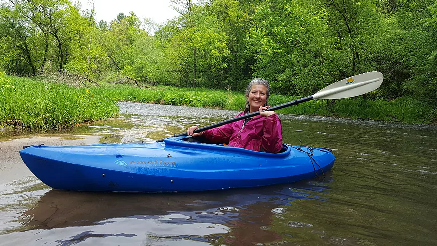
Finally, at 9:45 a.m., we were able to embark in our kayaks—mine donated to The River Raptors by Rutabaga Paddlesports LLC of Madison. (The put-in spot is located along the down-hill path at the base of a wooden stairs that drops down to the river, which takes a few minutes to reach. Best to carry one kayak or canoe at a time instead of dragging one down the hill stairs.)
Leaving from the put-in spot just below the dam at River Falls, I was concerned that the delayed start meant fewer species recorded, but I also knew that we still had a band of showers (but no forecasted lightning according to Nina’s special AP on her smartphone), and potentially long-distance migrants with the storm, coming from the southwest, which might mean some good luck.
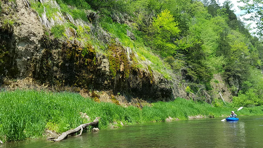
Across from our put-in spot was a limestone outcrop, and here 3-4 pairs of Northern Rough-winged Swallows were coming and going from rock crevices and openings, suggesting likely nesting. Tree Swallows and a few Bank Swallows were also present.
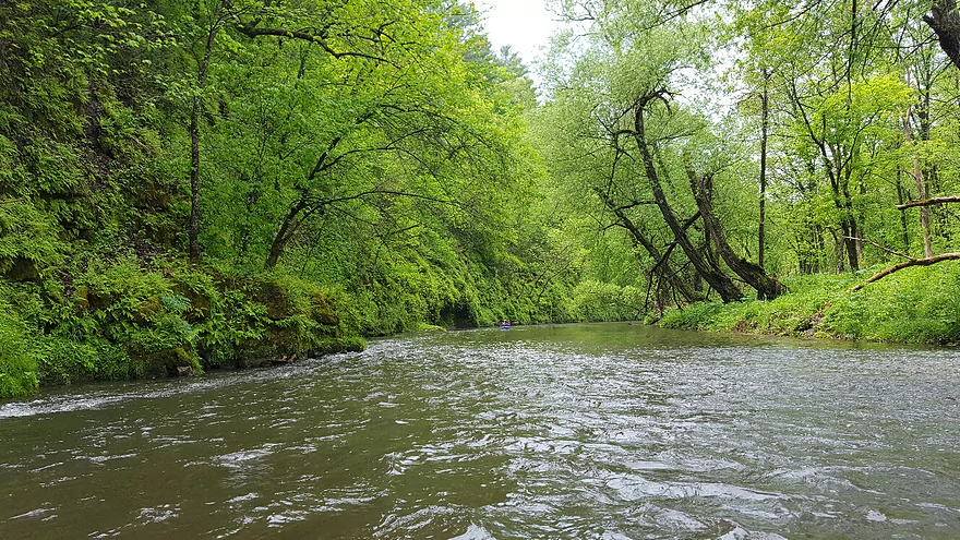
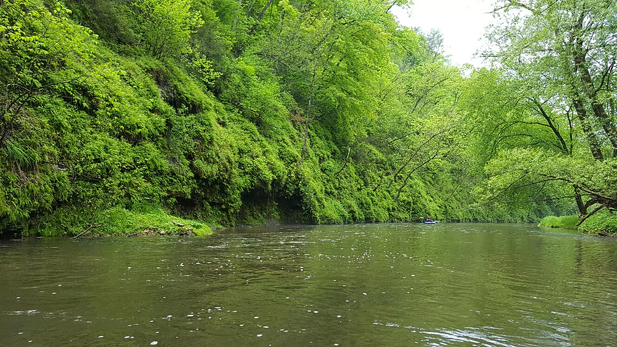
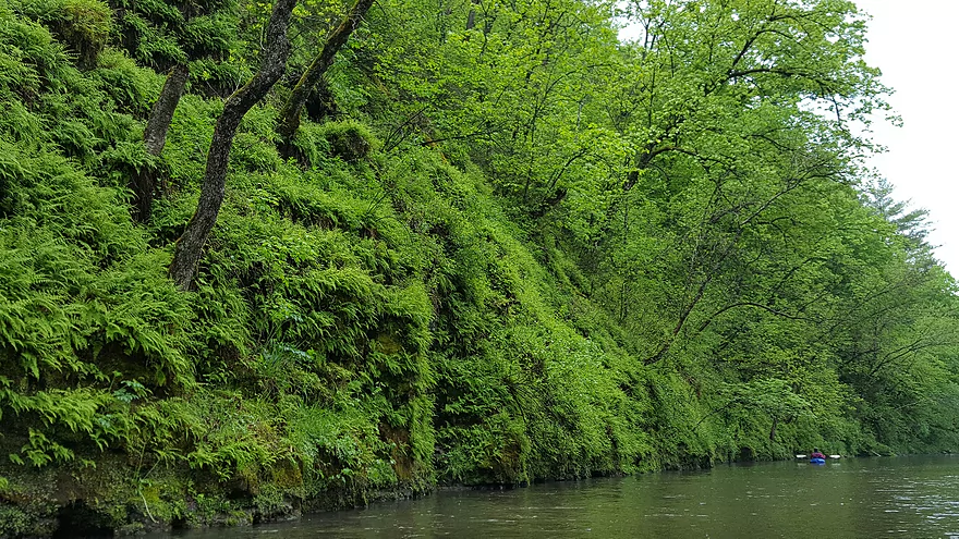
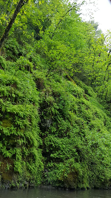
I have never been to the Kinnickinnic River before, much less heard it talked about as a desired destination for birders (Daryl Tessen includes a reference to it in his Wisconsin’s Favorite Bird Haunts, Fifth Edition) but Nina knew it well and suggested a trip for The River Raptors and the Great Wisconsin Birdathon. As we got underway, I was struck immediately by the pace of the water and the frequency with which we encountered shallow rapids. Then, rounding the first and subsequent bends, it was as if we had entered Eden—fern and shrub-covered hills and bluffs rose up around us as the river corridor narrowed. Trees were more dominant higher up the bluffs, especially along the ridge tops, where white pine stands were prominent. Lower down, birch and especially ironwood and yew dotted the hillsides. Lush stands of polypody ferns, walking ferns, and bulblet ferns grew on rock outcrops, and mosses wet from recent rains added a softness to the scene. The overwhelming beauty of prominent rich greens dripping towards and surrounding our small kayaks was, and is, unforgettable.
We encountered intermittent rain showers down this Class I river, and as we did we began to experience mini-fallouts of warblers, dominated by Tennessee Warblers, American Redstarts, and Blue-winged Warblers. In fact, the two most commonly detected bird species throughout the 7.5 miles of river we kayaked, were Blue-winged Warblers and Tennessees, in that order. We ended up with 20 warbler species in total, and the most rewarding and unexpected was a Worm-eating Warbler, heard apart and away from Chipping Sparrows—also quite numerous. Another fine revelation was a lone Philadelphia Vireo, and four separate and widely spaced Louisiana Waterthrushes—likely breeding here. The steep, shrubby hillsides and ravines reminded me of parts of the Baraboo Hills, and given what turned out to be miles of intact and undisturbed habitats (we saw only one ridgetop cabin), this gem of a “canyon” river offers an attractive breeding bird refugia in a wider agricultural landscape.
Nina observed bird species number 80—a sweeping Bald Eagle climbing above the river. After 4.5 hours of kayaking and birding, we reached our take-out at a bridge on County Highway F. We ended the day with 85 species—not bad given our delayed start. Other notable species present: Sharp-shinned Hawk, Red-shouldered Hawk, Wilson’s Snipe (flying past us up-river), Common Nighthawk, Red-headed Woodpecker, Yellow-throated Vireo, Blue-headed Vireo, and Evening Grosbeak.
The temperature at the end of the day—a warm and breezy 79 degrees. As an aside, I would not recommend this trip to a novice kayaker or canoeist due to some sharp turns and occasional fallen trees in the beginning or middle of rapids, unless one fully expects to get soaked occasionally, which on a warm day may not be unwelcome.
Addendum from Nina:
It was a magical day indeed! From the drama of the initially threatening weather, to the lush, encompassing greenness, to the fact that we had that stretch of the Kinni entirely to ourselves, other than encountering one fisherman standing midstream with his faithful golden retriever by his knee.
List of Birds Observed, 16 May 2017, Kinnickinnic River, Pierce County, 0945-1415 hrs, 7.5 mi:
Canada Goose, Yellow-throated Vireo, Louisiana Waterthrush, Baltimore Oriole, Wood Duck, Blue-headed Vireo, Northern Waterthrush, Mourning Dove, Philadelphia Vireo, Blue-winged Warbler, Common Nighthawk, Warbling Vireo, Black-and-white Warbler, Sandhill Crane, Red-eyed Vireo, Tennessee Warbler, Wilson’s Snipe, Blue Jay, Nashville Warbler, Spotted Sandpiper, American Crow, Common Yellowthroat, Great Blue Heron, Tree Swallow, American Redstart, Turkey Vulture, Northern Rough-winged Swallow, Cape May Warbler, Osprey, Bank Swallow, Northern Parula, Bald Eagle, Black-capped Chickadee, Magnolia Warbler, Sharp-shinned Hawk, Tufted Titmouse, Yellow Warbler, Red-shouldered Hawk, White-breasted Nuthatch, Chestnut-sided Warbler, Red-tailed Hawk, Brown Creeper, Blackpoll Warbler, Belted Kingfisher, House Wren, Palm Warbler, Red-headed Woodpecker, Blue-gray Gnatcatcher, Pine Warbler, Red-bellied Woodpecker, Golden-crowned Kinglet, Yellow-rumped Warbler, Yellow-bellied Sapsucker, American Robin, Wilson’s Warbler, Downy Woodpecker, Gray Catbird, Eastern Towhee, Hairy Woodpecker, Brown Thrasher, Chipping Sparrow, Northern Flicker, European Starling, Song Sparrow, Pileated Woodpecker, Cedar Waxwing, Scarlet Tanager, Eastern Wood-Pewee, House Sparrow, Northern Cardinal, Yellow-bellied Flycatcher, Purple Finch, Rose-breasted Grosbeak, Least Flycatcher, American Goldfinch, Indigo Bunting, Eastern Phoebe, Evening Grosbeak, Red-winged Blackbird, Great Crested Flycatcher, Ovenbird, Common Grackle, Eastern Kingbird, Worm-eating Warbler, Brown-headed Cowbird
Thanks Sumner and Nina for the review! Below are some further details on the Kinnickinnic that I’ll share with readers.
For the flow-rate, 110 CFS might be average and this trip was done at 158 CFS. At levels 100 CFS and lower the river might be pretty shallow, while at higher CFS levels (maybe 250+ CFS), the river may become too pushy and murky.
Note, on weekends I hear the Kinnickinnic can be very popular and it may be wise to do this on a weekday (as Sumner and Nina did) to avoid the crowds.
For shuttles and rentals there is Kinni Creek Lodge (715-425-7378).
Below is a big picture overview of the river:
- Upstream of Hwy JJ: The river is likely navigable this far upstream but I don’t know much more.
- Hwy JJ to Hwy 65/N. Liberty Road Launch: 4.2 miles. Probably a nice stretch.
- Hwy 65/N. Liberty Road Launch to Hwy 35: 4.1 miles. A lot of kayaks appear in satellite view so likely a good stretch.
- Hwy 35/N. Quarry Road to Heritage Park: 2.2 miles. Likely a nice prospect.
- Heritage Park to Winter Street Dam: 0.5 miles. Mostly flowage paddling on Lake George.
- Winter Street Dam to Glen Park: 0.5 miles. This consists of Lake Luise, a small flowage lake. I am not sure how easy of a portage the Winter Street dam is or if you can launch from there (but it is scenic).
- Glen Park to Hwy F: 8.1 miles. The most popular section and reviewed here.
- Hwy F to Mouth: 2.8 miles. This segment flows entirely through Kinnickinnic State Park. Take-out is on a beach upstream on the Mississippi right after the mouth. There is a trail that connects the beach to the public parking lot, but it would require that you drag your boat 1300′ up a hill.
- Mouth to Prescott/Mercord Mill Park: 6.3 miles. If you really want to paddle to the mouth, but not climb 1300′ up a hill, your other option is to paddle 6.3 additional miles on the St. Croix.
Note for additional river access information, see KinnniRiver.org. An interactive map with many access options can be seen here.
Trip Map
Photos Size:
Survived it…it was lovely just solid ripples….but also got to ‘enjoy ‘ it with at least 100+ other kayakers….but what to expect on memorial day eh? (my daughter had off from work that day…so had to bite the bullet). It is really in a deep gorge without any way to really get out of it…so once you are in…you are in. also…we did it at about 138 cfs…..and that was adequate…a few bumps on rocks but nothing major…if it gets down to 120 or 110 cfs I doubt it I would do it cuz you would end up having to do lots and lots of walking….with no exit. Would love to have had 150 cfs. I will definitely do it again on a weekday ….and avoid the lines of paddlers that were in there. They were all having fun tho…and it is not an apple river drink fest type of river yet. With the 100 degree heat we enjoyed getting into the very swift current and floating between rapids….and then just sat in the water to eat. Nice clear water and very zippy.
Gaila
It is not possible to kayak the Kinni north of the 65 put in. Farmers have several barbed wire fences across the river. Not enjoyable to come upon.
Thanks for the update.
We paddled the ‘Kinni’ on 8/5/22, Water levels low, 95 CFS, but other than just a few bumpy spots in some of the riffles, I did not think it was to shallow, and water clarity was amazing. We were both in boats with fairly flat bottoms, but boats with V hulls and tandem canoes may have issues at these levels I did a bike shuttle while my paddling partner waiting with the boats at Glen Park. Other than the BIG hill, right at the start on Hwy F it was a very easy and pleasant shuttle through rolling hills and past small farms. The trail from the park offers two options, stairs or a rutted path. Neither is fit for a cart so you will have to carry or drag your boat down to the landing. There is easy access to the water at the landing and, depending on your skills and the water levels, there may be some fun waves to surf coming from the dam spillway. The fun riffles start almost immediately and continue on and off for the entire length of the river. The water was amazing clear and the bottom varied between rocks, pebbles, and sand. The banks are mostly tree lined for the first half and then the bluffs start, with several areas of moss covered seeps that were truly spectacular The river stays fairly narrow, shallow, and sinuous for the entire 8 miles until you reach Hwy F, you can take out there or continue on to the confluence with the St. Croix. The bluffs get bigger but the river slows down, and the parking lot is up a huge long hill, so most people choose to take out on F. It is worth the short drive to Kinnickinnic State park to check out views of the confluence of the two rivers. While there are some areas that require a bit of boat control, and a few deep holes (great for trout fishing) most of the river is shallow and is suitable for anyone except perhaps absolute beginners. Here is a link to a map and pics of my trip using the app Relive (which I highly recommend) https://www.relive.cc/view/vRO7gkXgRyO
Thanks for the updated information and pictures!
The U.S. Army Corps of Engineers is considering removing two dams on the Kinnickinnic River. This would be a very good thing and could open a really neat stretch for kayaking. A recent open house was hosted to get public input on this issue: https://mailchi.mp/61dd1d3b5125/public-open-house-tomorrow-night-600pm-rf-public-library?e=3c5830850f