Put-in at Bell School Road

Scenic bridge

Flowing potamogetons show the way

Shallow to start the trip

But good clarity

Reverse view

There were a number of clams

Nice gravel bottom

Another small but nice boulder garden

Fantastic clarity

A few light rapids

Train tracks parallel much of the creek

Yet another train

Another great boulder garden

Scenic creek

Lot of pond weeds (maybe a gift from East Troy’s sanitation plant)

Some lillies

Hill Valley Road and another Hobbiton bridge

More great clarity

I never had to deal with any logjams

This fawn is trying to stay hidden

Great sandy, clear stretch

Beat up old bridge

Another train

Entering a wooded stretch next to a drumlin

Light rapids

Last train of the trip

One fat toad

Taking out at Hwy 20

Big embankment, but a good bridge access


Honey Creek – Walworth County


Date:
June 18th, 2022
Put-in:
Bell School Road
Take-out:
Hwy 20
Distance:
3.3 miles
Time:
Figure 1-2 hours
Water Level:

Honey Creek is an obscure Illinois Fox tributary located in Southeast Wisconsin.  It’s not nearly as popular as other nearby rivers (such as the Bark, Turtle, Mukwonago or Illinois Fox).  This isn’t because it isn’t nice (which it is), but because most don’t simply know it exists.

There are multiple legs you can do on Honey Creek, but a great starter stretch is Bell School Road to Hwy 20.  After I put in at Bell School Road, I encountered a number of shallow spots in the first quarter mile.  Paddlers shouldn’t be too discouraged as the rest of the creek is much deeper and the relative lack of mud makes wading pretty easy.

If you’ve ever paddled the Mukwonago or Bark Rivers, Honey Creek will seem very familiar.  It averaged 30′ in width, and aside from some exceptions was typically one foot deep.  The shoreline was relatively flat and marshy with a smattering of trees.

One of the highlights was the incredibly clarity and attractive gravel bottom.  This was a healthy creek with a lot of aquatic diversity containing many clams, snails, fish, and dragonflies.  It was also a very rocky creek with several nice boulder gardens.  These I suspect were a gift from the last Ice Age when the Michigan Lobe created a terminal moraine in this region.

If you’re into train watching, you may have another reason to enjoy this trip.  Parallel tracks closely follow much of the creek and there was a lot of train traffic.  I must have seen five trains roar by.

Two-thirds into the trip I encountered Hill Valley Road, which would be a doable and scenic bridge access.  Just prior to the bridge is an attractive boulder garden and shady woods.  The bridge itself contains fantastic stone work and is very photogenic.

After Hill Valley Road the creek widened, got sandier, and slowed…but stayed scenic and it was here I found some of the best clarity of the trip.  The final leg flowed under an attractive tree canopy sandwiched between a drumlin on the right and a railroad embankment on the left.  Here there were several light riffles, but nothing qualifying as serious rapids.  I ended the trip at Hwy 20 which was an ok bridge access. 

In summary this was a surprisingly nice trip and fans of the Mukwonago River will love this creek.  I suspect much of its length (East Troy to Burlington) is navigable and I look forward to returning to find more stretches to paddle.

Noteworthy Wildlife:

Sights included snails, dragonflies, an owl, three softshell turtles, and a fawn hiding in the weeds.  The highlight was all the fish.  The carp hung out in the deep spots, whereas everybody else hung out in the shallows.  Most of the “non-carp” were small, but I thought I saw a teenage pike.

Put-in:

Bell School Road:  This is an ok bridge access.  A faint trail on the west/downstream side leads to the water.  Be careful though as while the creek doesn’t have much mud, the put-in is an exception.  I stepped in the wrong spot and went up to my thigh in mud.  Choose your launch spot carefully.  Parking is a bit tight on the steep shoulders…you may have to leave your car a bit further from the bridge than usual.

Alternate Put-ins:

  • Carver School Road (3.7 miles upstream from my put-in):  This has a dam to portage and maybe several logjams, but this stretch is a good prospect and on my todo list.

Take-out:

Hwy 20:  This was a good bridge access.  There is a pull-off northwest of the bridge, and while the embankment is on the larger size it’s not difficult to hike up.

Alternate Take-outs:

  • Hwy D (3.0 miles downstream from my take-out):  This leg likely wouldn’t be as good as the upstream sections and may have a few more obstacles, but it’s still a solid prospect.

Shuttle Information:

Bike Shuttle:  Hwy 20 to Bell School Road – 2.2 miles with 10′ of ascent.  This was an easy bike shuttle…short with few hills.  The shuttle route goes past a historic school house built in 1853.

Hazards, Logjams and Current:

Honestly there weren’t hazards on this stretch.  I never had to portage a logjam and the current outside of a few riffles was mostly pretty slow.

River Depth and Navigability:

Trip Gauge:  Mukwonago River @ Mukwonago – 40 CFS or 2.34′.  Note Honey Creek doesn’t have its own gauge, so I’m using the Mukwonago gauge as a reference which may not be accurate.

  • 0-27 CFS:  Probably too shallow.
  • 28-35 CFS:  Creek will start quite shallow and this will require some wading.  After that, the creek will get deeper, but you’ll likely still need to wade most of the riffles.
  • 36-45 CFS:  Good clarity and some shallow spots to start, but mostly a manageable depth.
  • 46-65 CFS:  An average depth for spring.  A good target range, although clarity won’t be as good.
  • 66-85 CFS:  Good depth for paddling, but clarity will likely be poor.
  • 86-120 CFS:  A high depth and suitable for paddling, although the river likely won’t be as interesting.
  • 121+ CFS:  These might be flood conditions and a poor time to paddle the creek.

Honey Creek Overview:

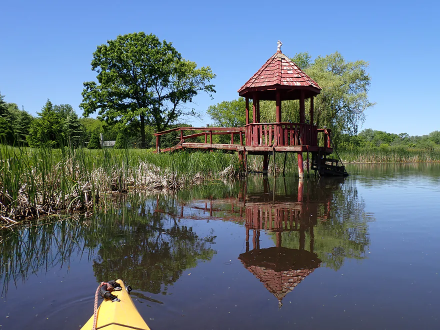
  • Carver School Road to Hwy 20:  0.9 miles.  Very open stretch.
  • Hwy 20 to Bell School Road:  2.8 miles.  One dam to portage and several logjams…but a good prospect.
  • Bell School Road to Hwy 20:  3.6 miles.
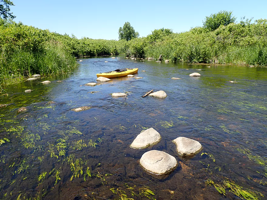
    • Bell School Road to Hill Valley Road:  2.1 miles.  Nice rocky stretch with clear water.  Starts shallow, but gets deeper by the railroad tracks.
    • Hill Valley Road to Hwy 20:  1.6 miles.  Another great stretch with more clarity.  Nice wooded leg near the take-out.
  • Hwy 20 to Hwy D:  3.0 miles.  A good prospect, but maybe a logjam or two.  Likely not as nice as the upstream legs.
  • Hwy D to Old Hwy DD:  0.8 miles.  Creek starts to widen, but should still be nice.  Maybe one logjam.
  • Old Hwy DD to Hwy DD/Honey Lake Public Beach:  2.3 miles.  Maybe one to two logjams.
  • Hwy DD to Spring Prairie Road:  2.5 miles.  Starts with a narrow old millrace that looks interesting.  Then opens up into a marsh area.  Maybe one logjam.
  • Spring Prairie Road to Echo Lake Boat Launch:  0.9 miles.  Simple stretch slowed by a downstream dam.
  • Downstream Options:  Echo Lake marks the confluence of the White River, Honey Creek and the Illinois Fox River.  There are additional take-out options on Echo Lake as well as downstream trips you can take on the Illinois Fox.

Trip Map

Overview Map

Video

Photos
Size:

2 Comments to “Honey Creek – Walworth County”

  1. Hi! Great post on Honey Creek! I’m planning on accessing this same section of stream in a few weeks and just wondering: if I’m looking to explore the first 0.5 miles downstream from the Bell School Road would I be better served in a canoe or waders? From your pictures it seems very navigable by foot—or am I being fooled by camera perspective? Thanks!!

    1. So are you looking to do like fishing?  If so, waders would be your better bet.  That leg of the creek is pretty shallow and will be at this time of year.

How did your trip turn out? Questions or comments? Feel free to leave your feedback.

SUBMIT COMMENT!
Be notified when future paddle reviews go live by subscribing!
Contact WisconsinRiverTrips.com