
- Trip Log
- Allen Creek - 1
- Allen Creek - 2
- Alto Creek
- Apostle Islands
- Arnold Creek
- Ashippun River - 1
- Ashippun River - 2
- Bad Axe River
- - NF - Duck Egg Park
- - SF - Hwy NN
- - SF - Purdy
- Badfish Creek
- - Hwy A to Old Stage
- - Old Stage to Casey
- - N Riley to Mouth
- Badger Mill Creek
- Bakken's Pond
- Baraboo River
- - Schultz Park
- - Union C. to Wonewoc
- - Wayside to Kalepp
- - Kalepp to D. Hollow
- - D. Hollow to La Valle
- - La Valle to Redstone
- - Rock Springs
- - North Freedom
- - Giese Park
- - Baraboo Rapids
- - Glenville Landing
- - Cascade Mountain
- - Floodplains
- Bark River
- - Merton
- - Hartland
- - Delafield
- - Rome
- - Cushman Road
- - Prince's Point
- Bass Creek
- Bass Lake
- Bear Creek MN
- Bearskin Creek
- Beaver Creek
- Beaver Dam River
- Belle Fountain Creek
- Big Creek
- Big Eau Pleine River
- - Elderberry Rd
- - Cherokee Park
- - Hazelnut Road
- - March Rapids Park
- - Big Rapids Park
- Big Green River
- Big Rib River
- - Lemke
- - Amco Park
- - Hwy A
- - Marathon City
- Big Slough
- Big Spring Creek
- Billings Creek
- Bittersweet Lakes
- Black Creek
- Black Earth Creek
- - Cross Plains
- - Salmo Pond
- - Town Black Earth
- - Mazomanie
- - Winter
- - Mazo to Hudson
- - Blue Mounds Creek
- Black River
- - Wayside park
- - Greenwood
- - Christie
- - Neillsville
- - Lake Arbutus
- - Hatfield
- - Power House
- - Flowage
- - Black River Falls
- - Mason
- - Irving
- - Melrose
- - Hwy 53
- - Van Loon Forest
- Black River - East Fork
- - Steponik Road
- - Pray Road
- - Overguard Road
- Blue River
- - Bluff Road
- - Snow Bottom
- - Hwy G
- Bois Brule - 1
- Bois Brule - 2
- Bois Brule - 3
- Bridge Creek
- Buffalo River
- Castle Rock Creek - 1
- Castle Rock Creek - 2
- Catfish Creek
- Cedar Creek - 1
- Cedar Creek - 2
- Chapman Creek
- Coon Creek
- - Hwy P
- - Coon Valley
- - Chaseburg
- Copper River
- Cox Hollow Lake
- Cranberry Flowage
- Crawfish River
- - Columbus
- - Goat Island
- Crystal River
- Dead Creek
- Deer Creek (MN)
- Dell Creek
- Devil's Lake
- Dickey Creek
- Door County
- Door Creek
- Duck Creek
- Duck Creek MB
- East Twin River - 2017
- East Twin River - 2021
- Eau Claire - Chip. Trib.
- - North Fork
- - South Fork
- - Harstad park
- - Big Falls Park
- Eau Claire - Douglas
- Eau Claire - Marathon
- - East Branch 1
- - East Branch 2
- - Bear Lake Rd
- - Dells Flowage
- - Dells Park
- - Weston
- - Guest Review
- Eldorado Marsh
- Elk River
- Embarras River
- Fever/Galena River
- - Knee Deep
- - Benton
- - Strawbridge
- - Illinois Border
- - Galena
- Fish Lake
- Flambeau River
- Fond du Lac River
- Fox River
- - Pardeeville
- - To Swan Lake
- - To Portage
- - Portage to Gov. Bend
- - Gov. Bend to Hwy O
- - Endeavor
- - Montello
- - Princeton Locks
- - White River Locks
- French Creek
- Good Earth Creek
- Gordon Creek
- Grand Island
- Grand River
- - Utley
- - Hwy H
- Grant River
- - Jones Branch
- - Rogers Branch
- - University Farm
- - Short Cut Road
- - Grant River Rd
- - Hwy U
- - Camel Ridge
- Halls Creek - 1a
- Halls Creek - 1a
- Halls Creek - 2
- Hay River
- Hemlock Creek
- Honey Creek - SC
- - Leland
- - Hwy C to Elm Rd
- Honey Creek - WC
- - Carver School Road
- - Bell School Road
- Hulburt Creek
- Illinois Fox River
- - Poplar Creek
- - Fox River Park
- - Hwy ES
- - Silver Lake
- - Starved Rock
- Jump River - 1
- Jump River - 2
- Jump River - 3
- Kettle River
- Kickapoo River
- - Wilton
- - Guest Review
- - Black Valley
- - High School
- - Ontario
- - Ontario
- - Bridge 4 to Bridge 7
- - Bridge 7 to Bridge 14
- - Rockton
- - Tunnelville Cliffs
- - Readstown
- - Gays Mills
- - Plumb Creek
- Kickapoo River WF - 1
- Kickapoo River WF - 2
- Kinnickinnic River
- Kinnickinnic River - Milwaukee
- Kishwaukee River
- Kittleson Valley Creek
- Knapp Creek
- Koshkonong Creek
- La Crosse River
- - Fort McCoy
- - Sparta
- - West Salem
- - Veterans Memorial Campground
- - Onalaska
- Lake Columbia
- Lake Delton
- Lake Redstone
- Lake Redstone
- Lemonweir River
- - East Fork 0
- - East Fork 1
- - East Fork 2
- - South Fork 1
- - South Fork 2
- - Kennedy Park
- - Mauston
- - 19th Ave
- - Hwy HH
- Lily River
- Little Eau Pleine
- Little Grant River
- Little Maquoketa River
- Little Platte River
- - Platteville
- - Stumpton to Hwy O
- - Hwy O to Church Rd
- Little Sugar River - 1
- Little Sugar River - 2
- Little Turtle Creek
- Little Wolf - SB 1
- Little Wolf - SB 2
- Little Wolf River
- - Ness Rd
- - Guest Review
- - Wolf River Road
- - Little Falls
- - Kretchner Road
- - Manawa
- - Royalton
- Loxahatchee River
- Lunch Creek
- Lytle Creek
- Madeline Island
- Manitowoc River - 1
- Manitowoc River - 2
- Maquoketa Riv - NF1
- Maquoketa Riv - NF2
- Maquoketa Riv - NF3
- Maquoketa River - 1
- Maquoketa River - 2
- Marsh Creek
- Maunesha River
- - Marshall Millpond
- - Hwy 73
- - Cherry Lane
- - Final Stretch
- Mecan River
- - Mecan Springs
- - Cumberland to 11th
- - 11th Road to JJ
- - Dakota
- - JJ to Hwy 22
- - Dixie Ave
- - Hwy 22
- - Germania
- Melancthon Creek
- Menominee River
- Menomonee River
- Mill Creek
- Mill Creek RC - Boaz
- Milwaukee River
- - Campbellsport
- - West Bend
- - Quaas Creek
- - Newburg
- - Waubeka
- - Fredonia
- - Thiensville
- - Downtown
- Milwaukee River EB
- Minong Flowage
- Mirror Lake
- Mississippi River
- - Halfmoon Water Trail
- - Long Lake
- - Crater Island
- - Goose Island
- - Blue Heron Water Trail
- - Marquette
- - Wyalusing
- - Glen Haven
- - McCartney Lake
- Mondeaux Flowage
- Montello River
- - Lawrence Creek
- - Westfield Creek
- - Harrisville
- - 11th Road
- Mormon Creek
- Morrison Creek
- Mud Lake
- Mukwonago River
- Mullet River
- Namekagon River
- - Namekagon Dam
- - Hayward
- - Groat Landing
- - County K Landing
- - Cty Road K
- Narrows Creek
- Neenah Creek
- - Oxford
- - Hwy A
- - Hwy P
- - Grouse Drive
- - Muskrat Road
- - Hwy CX
- Neenah Creek SB
- Nine Springs Creek
- Nippersink Creek
- North Bear Creek IA
- Oconomowoc River
- - Loew Lake
- - Monches
- - Okauchee
- - Fowler Park
- - Concord
- Oconto River
- Otter Creek
- - Blackhawk Lake
- - Hwy Q
- Pebble Creek
- Pecatonica River
- - Mifflin
- - Jones Branch Road
- - Powell Road
- - Hwy O
- - Darlington
- - Roller Coaster Road
- - Hwy 78
- - State Line
- Pecatonica River - AB
- Pecatonica River - DB
- Pecatonica River - EB
- - Hollandale
- - Horseshoe Bend Road
- - Blanchardville
- - Hwy 78
- - River Road
- - Blackhawk
- Pecatonica River - MB
- - Ludden Lake
- - N. Oak Park Road
- - S. Oak Park Road
- Pecatonica River - SB
- Perry Creek
- Peshtigo River
- Peshtigo River - O to CCC
- Pewaukee River
- Pheasant Branch
- Pictured Rocks
- Pictured Rocks
- Pine - Lincoln County
- Pine - Richland County
- - Norman Valley
- - Hwy 80
- - Rockbridge
- - Richland Center
- - Hwy O
- Pine - Waushara Cty.
- - Apache Rd
- - Saxeville
- - 28th Court
- - Poy Sippi
- Piscasaw Creek
- Platte River
- - Coon Hollow Road
- - Hwy A
- - Ellenboro
- - Platte Road
- Plover River
- - Esker
- - Bevent
- - Pinery Road
- - Hwy K
- - Stevens Point
- Popple River
- Portage Canal
- Potter Flowage
- Prairie River - 1
- Prairie River - 2
- Puchyan River
- Rat River
- Rattlesnake Creek
- Red Cedar River
- Red River
- Redgranite Quarry
- Rib Lake
- Roaring Creek
- Robinson Creek - 1
- Robinson Creek - 2
- Rock Creek
- Rock Lake
- Rock River
- -
- - Hustisford
- - Harnischfeger Park
- - Kaul Park
- - Kanow Park
- - Ixonia
- Rock River East Br.
- - Allenton
- - Theresa
- - Gill Road
- - Mayville
- - Horicon Marsh
- Rock River SB
- Rocky Run Creek
- - Dunning Road
- - Hwy 51
- - County V
- Root River (MN)
- Root River (WI)
- Root River NB (MN)
- Root River SB (MN)
- Rubicon River
- - Hartford
- - West Side Park
- - Neosho
- Rush Lake
- Rush River
- Sand Island
- Scuppernong Creek
- Scuppernong River
- Seeley Creek - 1
- Seeley Creek - 2
- Sheboygan River
- - Johnsonville
- - Kohler
- Sinsinawa River
- Six Mile Creek
- - Ripp Park
- - Castle Creek Conservancy
- - Woodland Drive
- Somo River
- Spirit River
- Spring Brook - 1
- Spring Brook - 2
- Spring Creek
- - Lodi Marsh
- - Downtown Lodi
- - Final Stretch
- St Croix River - 1
- St Croix River - 2
- Starkweather Creek
- Stony Brook
- Story Creek
- Sugar Creek
- Sugar River
- - Verona
- - Guest Review
- - Paoli
- - Hwy A
- - Belleville
- - Hwy X
- Sugar RIver - WB
- Tainter Creek
- Taylor Creek
- Thompson Creek
- Token Creek
- Tomahawk River
- Trappe River
- Trempealeau River
- Turkey River
- Turtle Creek
- - Guest Review
- - School Section
- - East Creek Road
- - Tiffany
- - Beloit
- Upper Iowa River - 0
- Upper Iowa River - 1
- Upper Iowa River - 2
- Upper Iowa River - 3
- Volga River - 1
- Volga River - 2
- Waupaca Chain O’ Lakes
- Waupaca River
- - Tomorrow River
- - Amherst
- - Buchholz Road
- - Stedman Park
- - Hwy Q
- Wazee Lake
- Wedde Creek
- Wedges Creek
- - Snyder Park
- - Final Stretch
- White Creek
- White River
- - West Branch
- - Wautoma
- - Neshkoro
- - 22nd Ave
- White River (S)
- Whitewater Creek - IA
- Whitewater Creek - WI
- Whitewater River - MN
- Wildcat Creek
- Willow Creek - 1
- Willow Creek - 2
- Willow Creek - 3
- Willow Creek - RC
- Willow River
- Wingra Creek
- Wisconsin River
- - Granite Heights
- - Stevens Point
- - Biron
- - Wisconsin Rapids
- - Port Edwards
- - Plank HIll
- - Petenwell Lake
- - Castle Rock
- - Upper Dells Part 1
- - Upper Dells Part 2
- - Blackhawk Island
- - Lower Dells
- - Pine Island
- - Portage
- - Dekorra
- - Merrimac
- - Prairie du Sac
- - Mazomanie
- - Arena
- - Spring Green
- - Lone Rock
- - Gotham
- - Muscoda
- - Boscobel
- - Woodman
- - Millville
- - Final Stretch
- Wolf River
- - Hollister
- - Langlade
- Yahara River
- - Deforest 1
- - Deforest 2
- - Hwy 19
- - Dunkirk
- - Stoughton
- - Stebbinsville
- Yellow Creek
- Yellow River - IA
- Yellow River - WI C
- - Yellow River Road
- - Hwy 10
- - Hwy 80
- - Hwy N
- - North Wood Park
- - Pittsville
- - Hwy F
- - Necedah
- Yellow River - WI NC
- - Hwy O
- - Hwy XX
- Yellow River - WI NW
- Yellowstone River
Waterproof Wisconsin Water Trail Maps
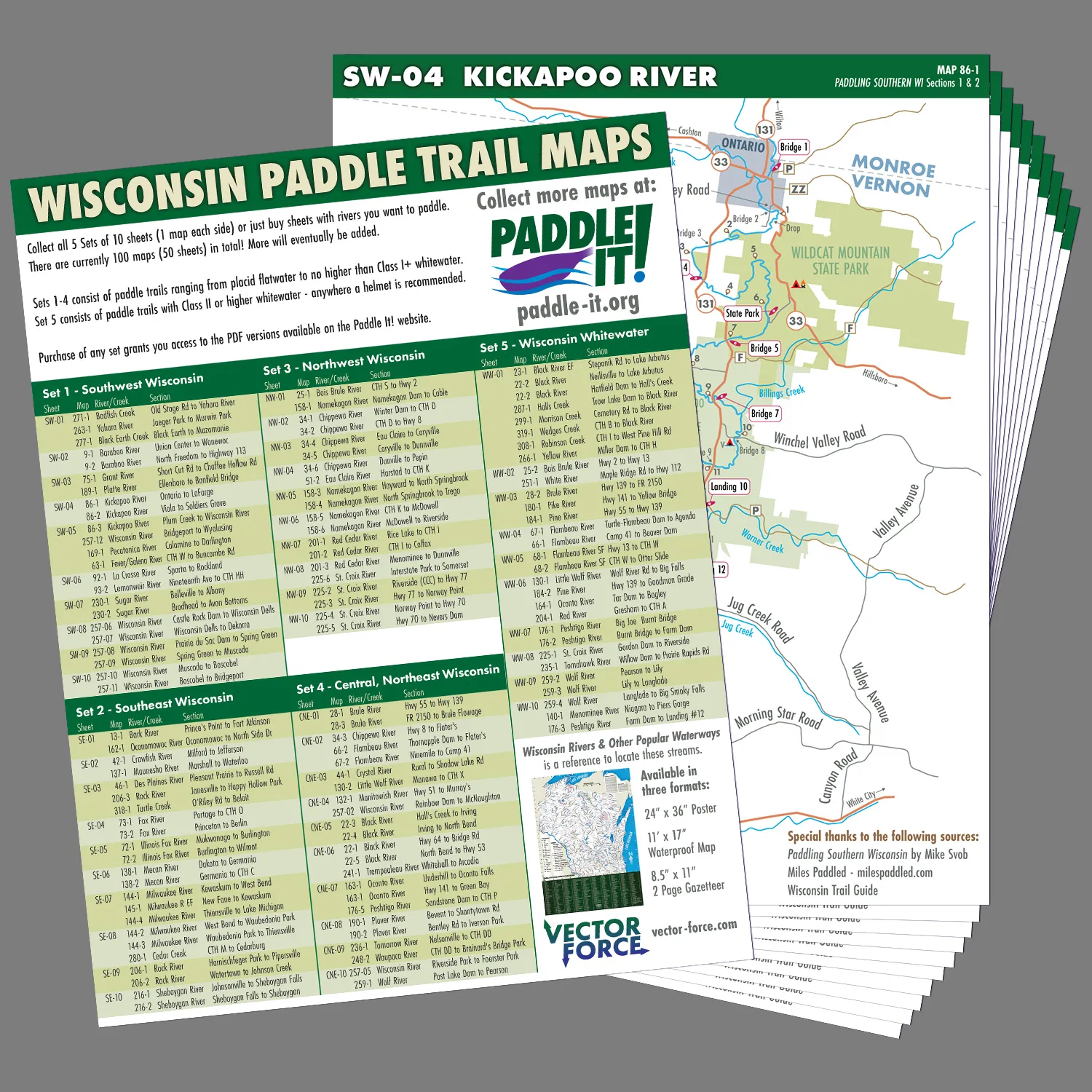
Jared Wold (who made the Wisconsin Rivers Poster) has recently launched a new series of waterproof paddle maps for Wisconsin. Over 100 maps will be included which will cover many of the state’s main water trails. You will be able to detach a specific map from its collection to bring along on a trip. This is a clever idea since cell service on rivers can be inconsistent (plus who wants to risk damaging/losing your phone or dealing with a dead battery). The maps will be grouped into five collections (four quadrants of the state plus a whitewater series). Each map will include mileage markers, access points and landmarks.
Click here for more details and to pre-order the Southwest Wisconsin collection.
WisconsinRiverTrips.com is not financially affiliated with Vector Force. I’m only linking to it because I think it is a neat idea!
How do I get the maps
Here is the link: https://vector-force.com/product/wisconsin-paddle-trail-maps-pre-order-special/
Hi. I’m interested in all the Wisconsin river map sets! Are they all available? And pricing? I only see the link to south east and south west Wisconsin.
Regards
James Guralski
Note, I don’t sell the maps. You should contact Jared for more information: https://vector-force.com/contact/