
Little Platte River
Overlooked by its bigger sibling, the Little Platte is a Grant County gem featuring terrific outcrops and rapids. This is one of the best paddling rivers in Southwest Wisconsin.
Trip Reports
Quarry Road to Stumpton Road Bridge
Date Paddled: May 31st, 2015
Distance: 6.35 Miles
Time: 5 hours 1 minute (atypical...expect 3 hours)
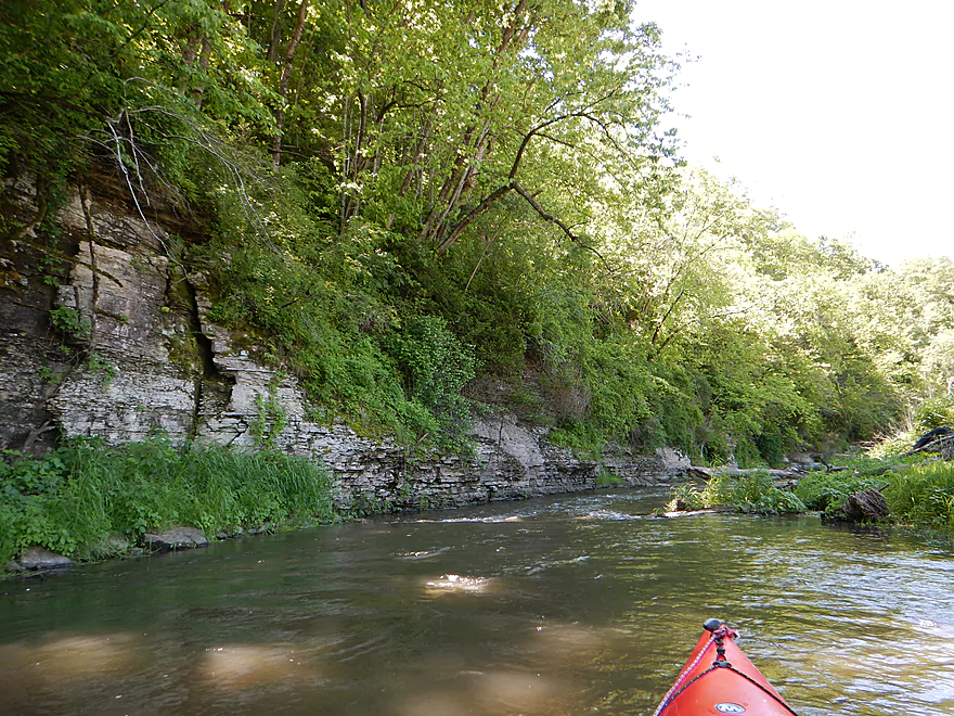
One of southern Wisconsin's crown paddling jewels featuring fun rapids and amazing limestone bluffs that rival the Kickapoo. Just be mindful of the cows, their fences, low water and high water...and you'll have a great trip.
Read More...Stumpton Road to Hwy O
Date Paddled: September 11th, 2016
Distance: 6.1 miles
Time: 4 hours 26 minutes (3 hours is more typical)
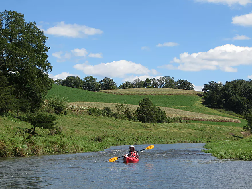
The Little Platte is a pleasant pastoral paddle with fun riffles and interesting geology.
Read More...Hwy O to Church Road
Date Paddled: July 7th, 2018
Distance: 4.7 miles
Time: 5 hours 30 minutes (2.5 hours would be much more typical)
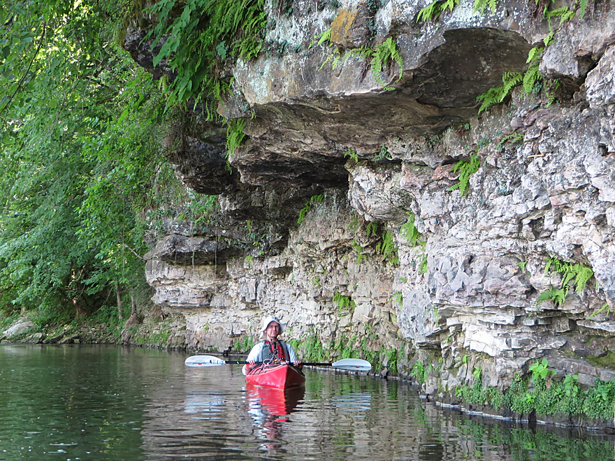
An exploratory paddle on the Lower Little Platte River that turned out surprisingly well. Highlights included limestone outcrops, driftless vistas, many light rapids, and no logjams.
Read More...Overview Map
Detailed Overview
- Arthur Village (Hwy A or 80) to Waterfall Road: 3.6 miles. Typically tiny, with perhaps some electric fences and definitely some downed trees. Rock outcrops by Arthur are impressive.
- Waterfall Road to Crosscut Road: 2.1 miles. An interesting creek prospect.
- Crosscut Road to Quarry Road: 5.9 miles. A curious prospect, but likely has a handful of downed trees.
- Quarry Road to Stumpton Road: 6.6 miles. A great five star section.
- Stumpton Road to Hwy O: 6.3 miles. A good four star section.
- Hwy O to Church Road: 4.7 miles. A great five star section.
- Church Road to Oak Road: 4.6 miles. Medium prospect. Maybe 1 outcrop and 8-12 logjams.
- Oak Road to the Mouth: 4.6 miles. Medium prospect. Maybe 11 logjams.
- Mouth to Indian Creek Road: 1.5 miles. A short section on a now very wide Platte River.
Nearby Guages
Videos
Comments
Thanks for the information, especially on the depth issues, bike shuttle, and fences. It's so upsetting to hear about these nasty fences. I really wish our "do nothing" DNR would wake up and seriously address this problem.
We paddled the section from Quarry Rd to Maple Ridge Rd on 4/14/24 levels were 4.12 ft and 120 CFS, although there were many shallow spots and some of the rapids were a bit bumpy, we never had to get out of the boats, and these were total doable levels.. Unfortunately there were at least 5 fences/wires strung across the river. Many appeared to be elcertic, but as they also had strands touching the water, so I don't believe they were active, as I would think that would ground them out. We were able to paddle over them without getting shocked, but we all took care not to touch the wire with our bodies or paddles. (FYI, Carbon fiber paddles do conduct electricity..I learned that the hard way) There is an active eagle nest about 1/2 way between the Cty B and Stumptown bridge on river left just after the Rountree Branch enters also from river left. This makes for a great lunch and eagle watching spot. We did a bike shuttle utilizing the dedicated bike path along Hwy 151. That said The shuttle starts out with a killer hill on Maple Ridge, but still is a beautiful shuttle and goes through the U of Platteville Campus. We saw numerous deer, eagles, hawks, cranes, herons, geese, ducks, and an otter.
Sounds like a good trip. I might have to do a Grant County paddle tomorrow myself...
We did the section from Old Lancaster to Cty O om 4/3/21 178 CFS and 4.5 ft. OK levels but would probably be better at 4.5-5 ft. We never had to walk the boats but there was a lot of scaping, bumping and "wheel chairing" through many of the shallow spots. On the upside the clarity was excellent and although good boat controlled was required in many places, all of places where the current pushes you into to the rock outcroppings were easily manageable. There were no complete blockages and no portages, but there was one place that was a bit tight. A tree is in the river from bank to bank,luckily the very top of the tree just barely reaches the right bank, so it is possible to squeeze through as the branches are thin and wispy. With just a bit of sawing and lopping work it would be fine.
Put-in at 12:30 took out at 4:40 with 30 min break. The bike shuttle (8.5 mile) took 45 mins. We saw eagles, geeses, ducks, kingfishers, muskrats,a mink,trout, a turtle, and just a few little bits of ice/snow hanging on in the shadiest portions of some of the rock faces
Appreciate the updates.
Ran the river from Quarry Rd to Stumptown Rd on September 17,2020, gage at 4.6' and 230cfs. Canoeing the trip took just under 2.5 hours, plenty of scraping, would look for something closer to 5.0 if running it again in a canoe.
The two barbed wire fences were non-events just pass under from the far left side. We portaged to the right to get around the downed tree as noted by others, also an easy portage.
Fun river, plenty of rapids. A pair of eagles were active at about the mid-point. Spots along to take out and relax.
Illinois paddling laws are completely backwards...I totally sympathize.
Been kayaking in Illinois but am disgusted with the laws here and am looking at Wisconsin. These articles are amazing and unbelievably helpful. I look foreword to posting my expectances once I get a chance to run them, although I doubt I can be as eloquent or helpful as these are.
So aside from the standing waves it sounds like 310 CFS was a manageable run which is good to know. Thanks for the updates.
Paddled from Quarry Rd. to Stumptown Rd. on 11June2020, Platte gauge at about 5.0 ft. and 310 CFS.
A tree was down between Old Lancaster and Hwy B, requiring an easy portage river left. There was a strainer in a bend of swift water upstream from the Stumptown bridge that required careful maneuvering.
A couple of times the standing waves were tall enough to splash water into the cockpit of my kayak, as I expected at this water level.
Notable wildlife:
A pair of Canada geese. One floated down the riffles in front of us, another bolted upstream. Maybe molting, as neither flew away. Raccoon, turkey, bald eagle, grebe, great blue heron, tadpoles at lunch stop.
Sounds like a great trip! Now, before scenery becomes obscured by leaves and gras,s is actually an underrated time to paddle.
Paddled from Quarry to Maple Ridge Rd today with a bike shuttle. Near perfect conditions, sunny, 60+, just enough green to make things look fresh and alive, but not enough to obscure any of the great rock faces, Levels were perhaps just a tad on the low side, 250 CFS/ 4.75 ft, so we scraped and bumped in some low spots and rapids, but never had to get out of the boats. The current was decent but never too pushy, but good boat control is required due to many sharp turns and currents want to direct you into rock faces Saw an eagle sitting on her/his nest, just a few cows, none in the water. many deer, some in the water, and a couple of geese with goslings. Bike shuttle is about 7 miles and took about 40 mins. The first hill is a bit steep, but after that is pretty easy, bike trails, small county roads and city streets
Aside from the fence, it sounds like these were fun water levels. Funny you should mention gnats and wild parsnip...they were a bane during my Sunday paddle too.
Paddled from Old Lancaster to Stumptown Rds. on 16 June 2019, at 5.2 ft. and 500 CFS. Ate lunch in our boats in an eddy, on-river time was about 2.5 hrs.
We put in river right, downstream from the bridge. Lots of wild parsnip to walk through while carrying boats, but long pants and long sleeves protected us.
If you use this put-in, don't forget to chain the gate closed behind you.
I didn't use a skirt in my crossover kayak, and some of the standing waves were big enough to splash water into the cockpit.
At about the 1/3 point, there was a downed tree on river left at a sharp bend, followed shortly by hard-to-see barbed wire very low to the water. If concentrating on avoiding the strainer, one might not see the wire in time. We'd brought wire lifters and eased under slowly, but at this water level or higher, caution is advised. As always, know your boat handling skills and be safe.
Clouds of gnats hovered around our heads for much of the trip. Bob Marley's song "(G)Natty Dread" took on a whole new meaning for me. I didn't notice any bites until the next day when a few appeared behind my ears. It was worth it to paddle this beautiful river at a frisky level.
Thanks for the update Eric! Lot of valuable information for other paddlers.
I took advantage of an early spring 70 degree day and did the section from Quarry to Maple Ridge Rd (the next bridge after
the Sumpton Rd bridge) on Mon 4/8/19. The gauges were about 180 CFS and 4.05 totally doable but I did scrape and bump a bit in many of the rapids. On the plus side there were no major jams and no fences across the river, on the negative side there was place where a tree had recently fallen completely blocking the river just after the Sumpton Bridge, but it was an easy portage on the right side. Also there were two spots where the bank had eroded and the fence posts with wire still attached were in the river. Luckily they both were parallel to the river and right along the bank so not hard to avoid, but could be dangerous in different conditions or if you did not see them ahead of time. Trip took about 4 hours with a 30 min stop for lunch. Nice bike shuttle through UW Plattvile Campus, it starts off with a BIG LONG hill but is OK after that. Saw 2 eagles, ducks, many nesting geese, big flock of turkeys, a few deer, some fish.
Appreciate the offer!
Drop us a line a week before your intended trip down the river from quarry rd to stumptown and if we are around we can follow one of you from quarry rd to stumptown and take you back to to quarry to ride the river
Not that I know... You might check with the Platteville Chamber of Commerce to see if they know of any new liveries. An idea might be to simply use a taxi service out of Platteville (which is practically next door) to do a car drop for you.
Is there a shuttle service company to move your vehicle downstream?
I appreciate the update Jon!
Did Quarry Lane to Stumptown Rd. on 5/6/2018
4.1 gauge height on Platte R. at Rockville, ~200 CFS. Wouldn't recommend levels any lower than this. Never had to exit our boats, but did have to push up a few times when got hung up. Lots of scraping and bumping over rocks. One downed log that took some time to scoot over. We'll try to catch the Little Platte at a higher level sometime.
Scouted put-in at Old Lancaster Rd, but didn't want to trespass, so didn't check to see if gate would open. Put in at Quarry Ln.instead. Barely ducked under the two electric fences between Quarry and Old Lancaster, but if river was up another few inches that would have been difficult. I may rig up an electric fence lifting tool out of small diameter PVC?
Most interesting wildlife: Turkeys flying across the river - one landed on the bank just in front of us.
Detailed note: The rock shown in your photo "crash landed borg cube" had a new obstruction on river right that pushed us much harder toward that rock than we expected. I'm pretty sure it was a tree branch, (I hit some branches with my paddle and snapped them off - briefly worried that the cracking sound was my paddle breaking.) Whether it was bad river reading, not making the right move, or the geometry of the rapid, all three of us took some water over the side of the cockpit. Two of us bumped off the rock.
How did your trip turn out? Questions or comments? Feel free to leave your feedback.
SUBMIT COMMENT!