
Starting the trip at the Jupiter Outdoor Center chickee
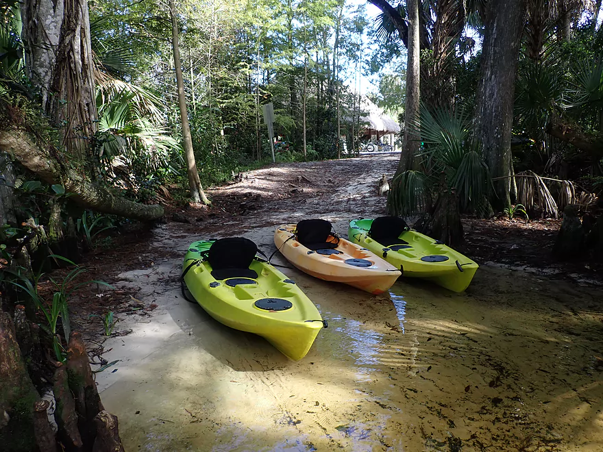
Great put-in
Caution – Alligators may be present
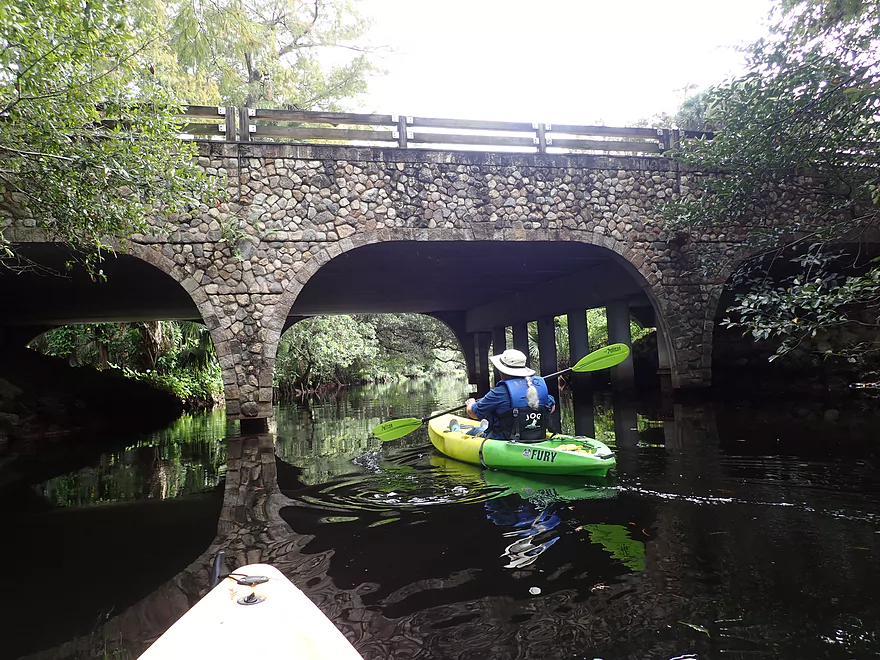
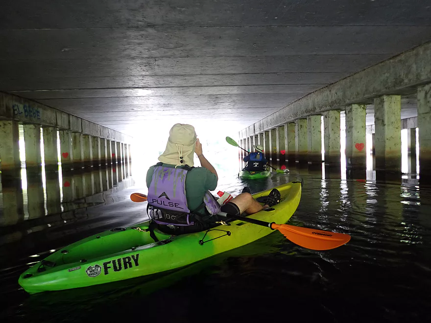
Paddling under a scenic cobblestone bridge
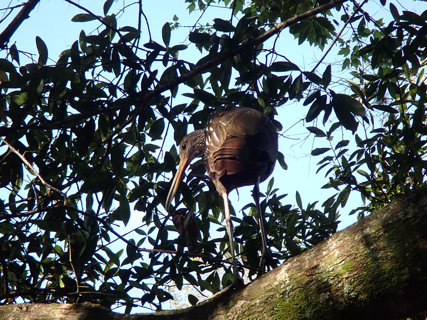
A limpkin looking for snails
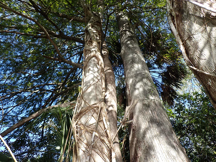
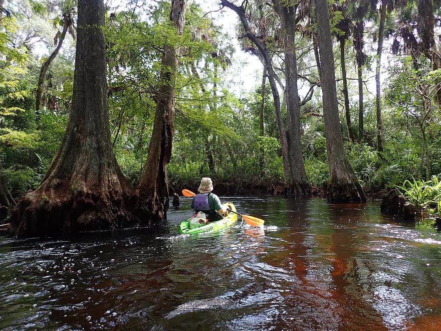
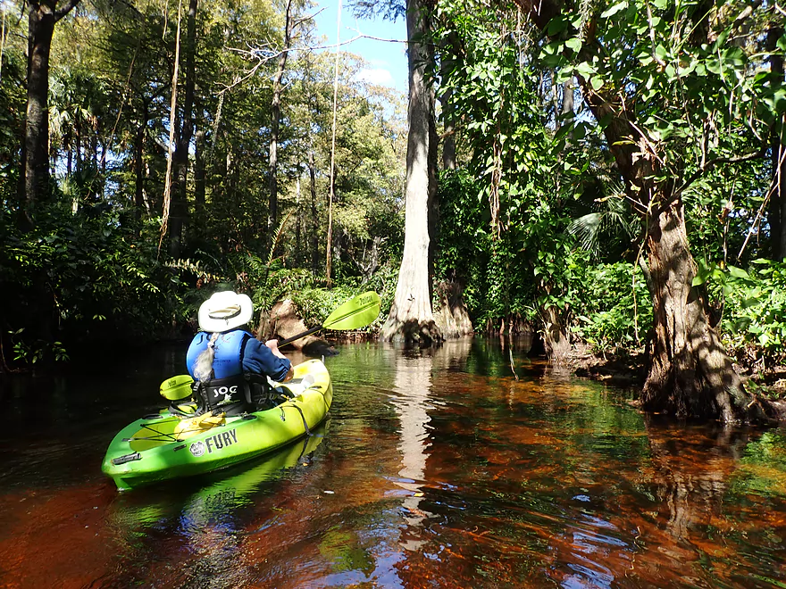
Twin cypress trees
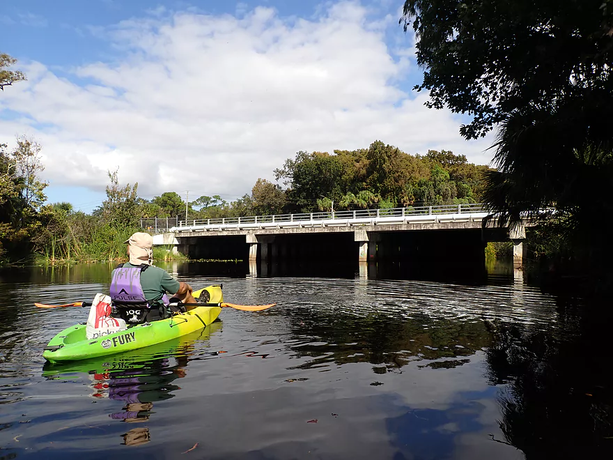
Hwy 706
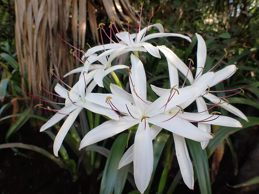
Swamp lilies (a member of the Amaryllis family)
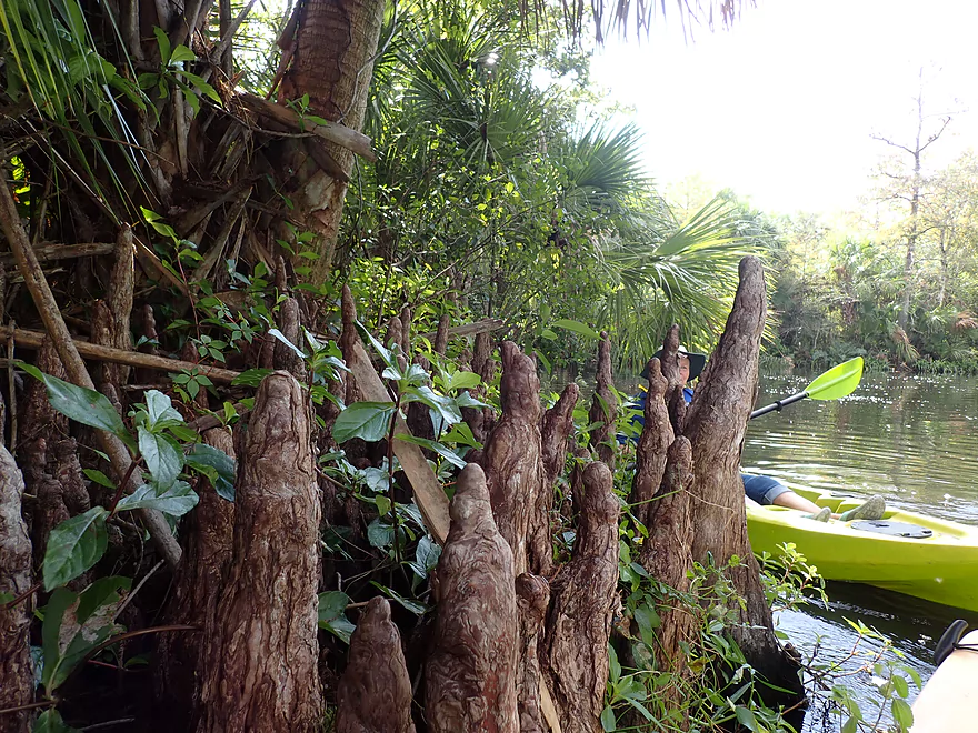
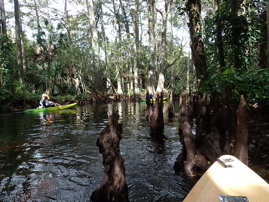
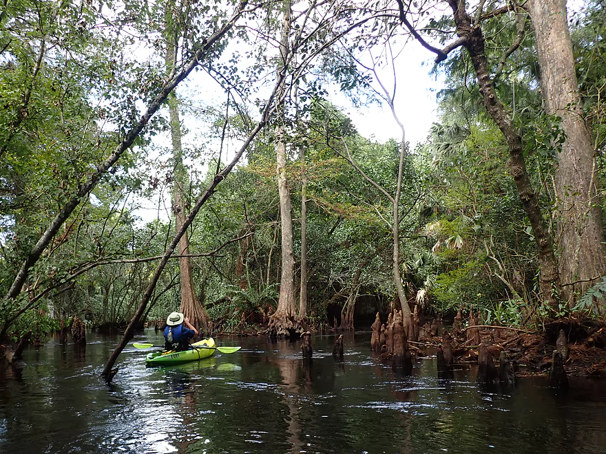
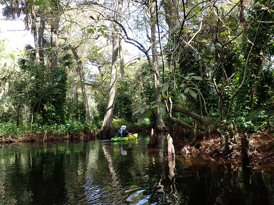
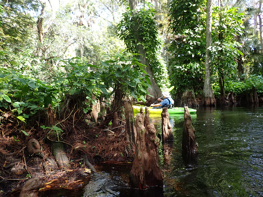
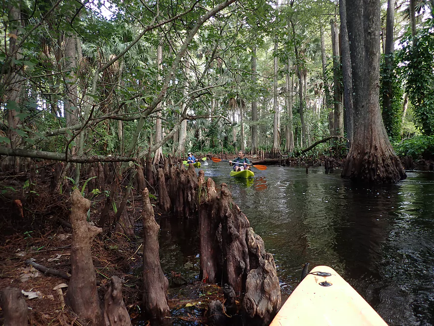
Cypress knees
Really cool
The tributary on the side connects with Peacock Lake
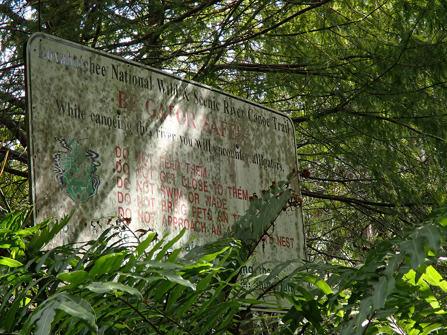
Be Gator Safe!
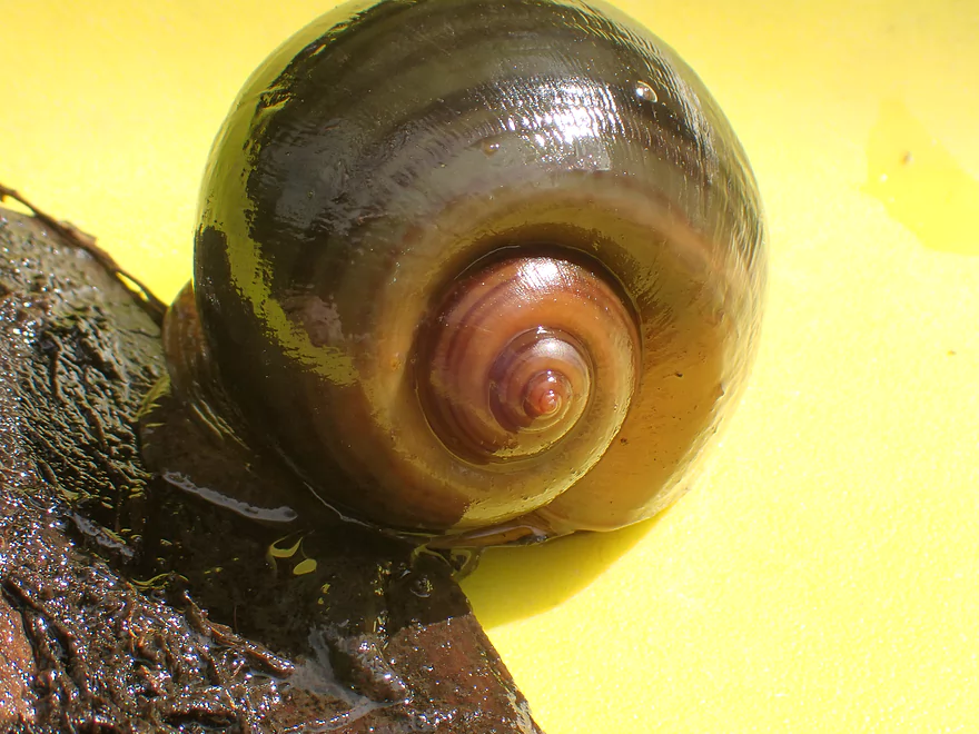
A large apple snail
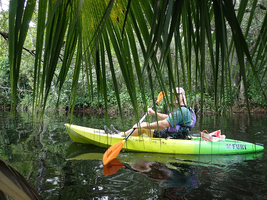
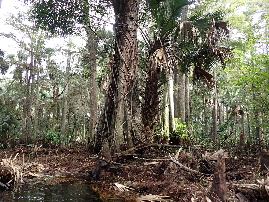
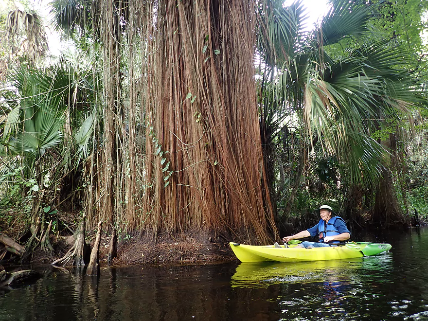
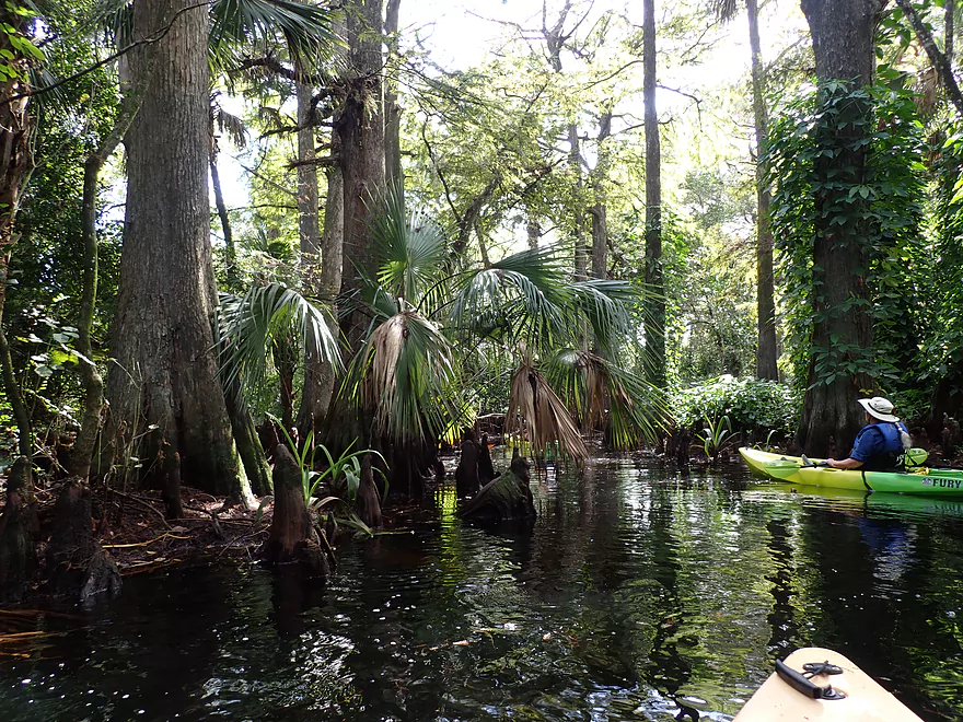
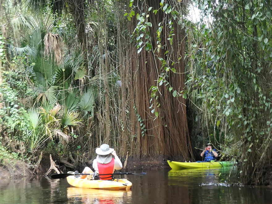
A curtain of palm leaves
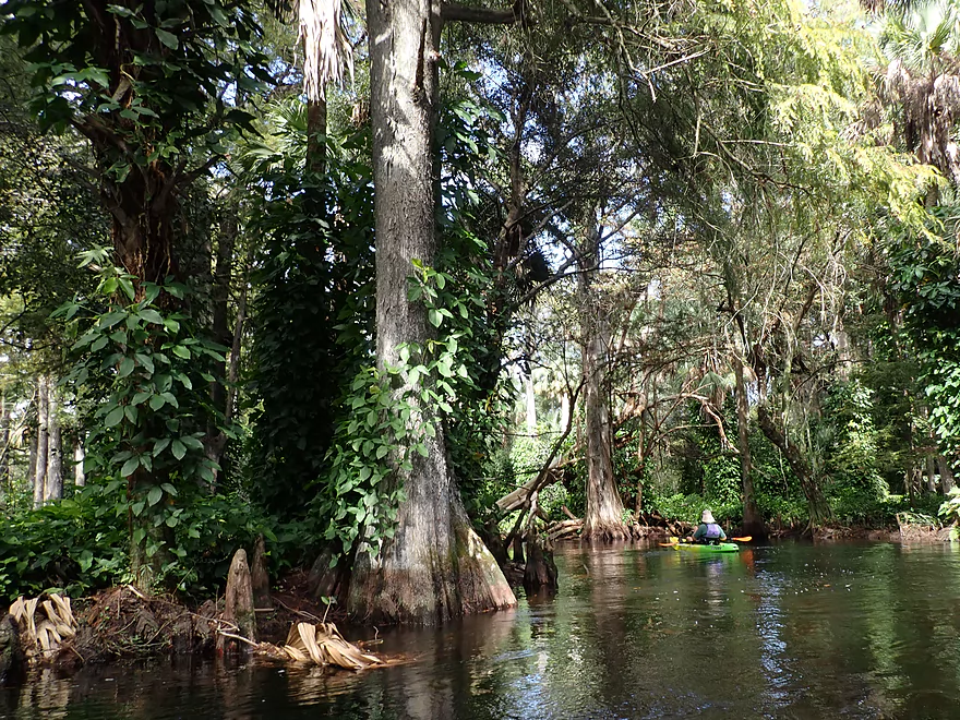
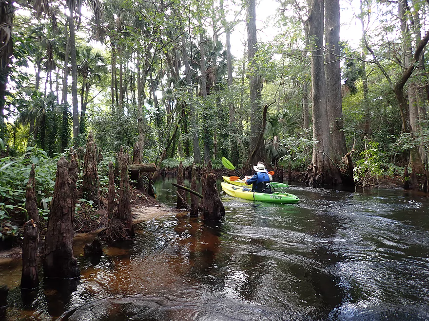
Coming up on a nice part of the river
Coming up on a USGS station and handy “bypass” boardwalk
You can portage the Lainhart Dam
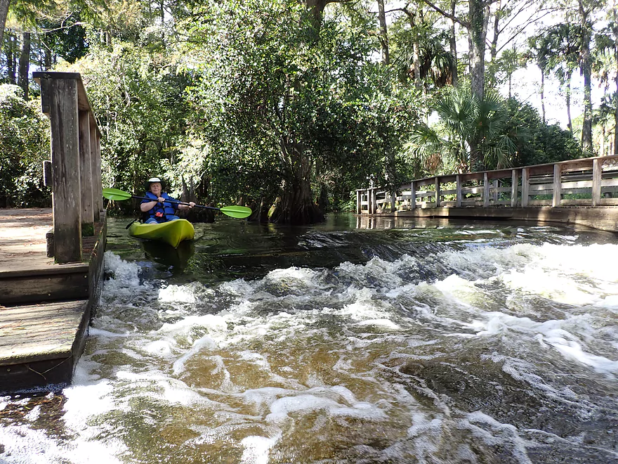
But you can run it instead
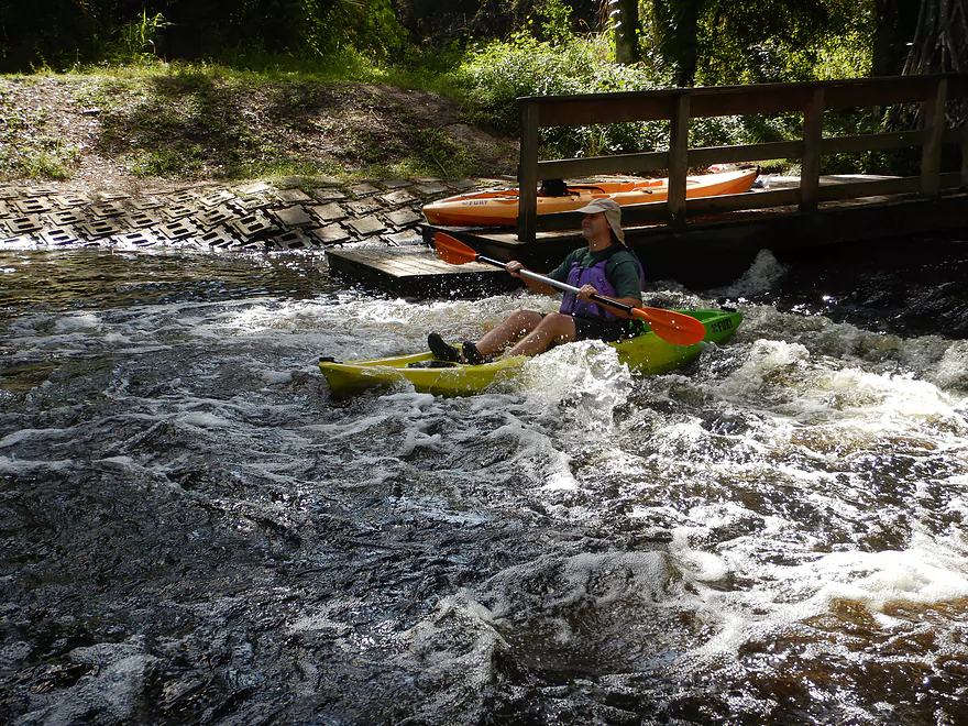
This could be considered Class 1 rapids
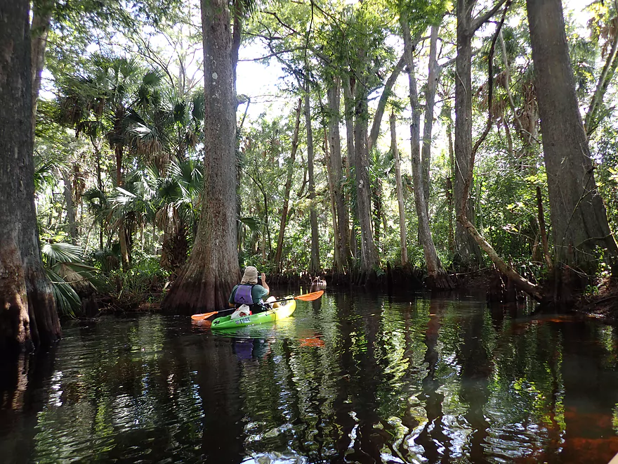
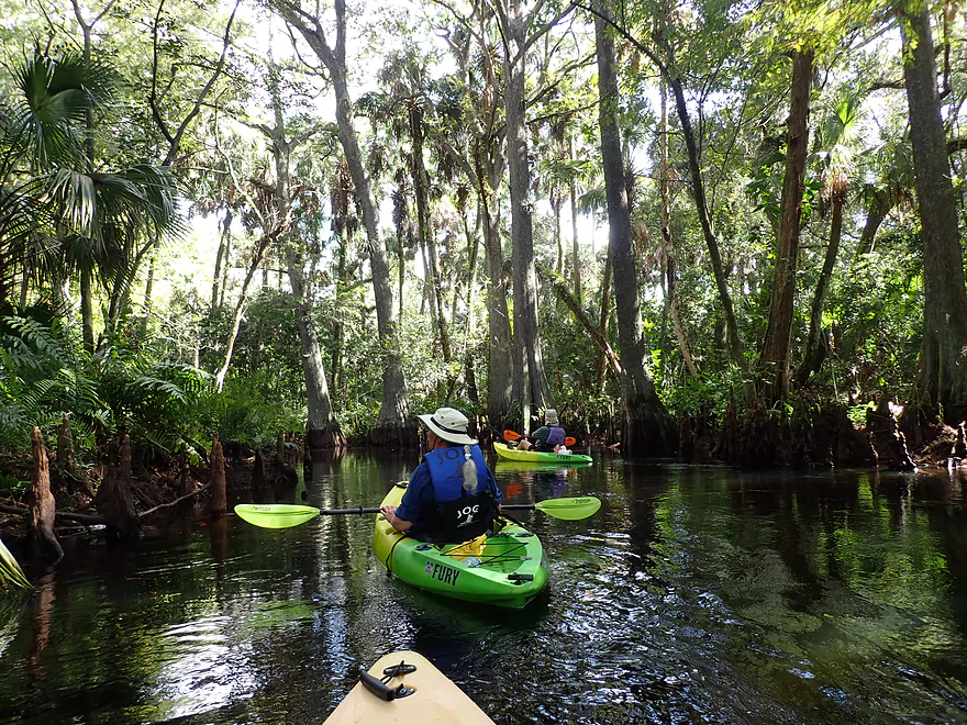
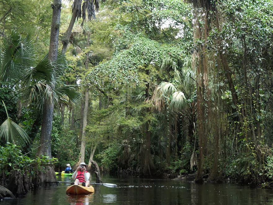
Fantastic cypress trees
The water looks black but was actually a dark tea color
More cypress knees
This strangler fig will eventually choke the host tree
Future gator snack
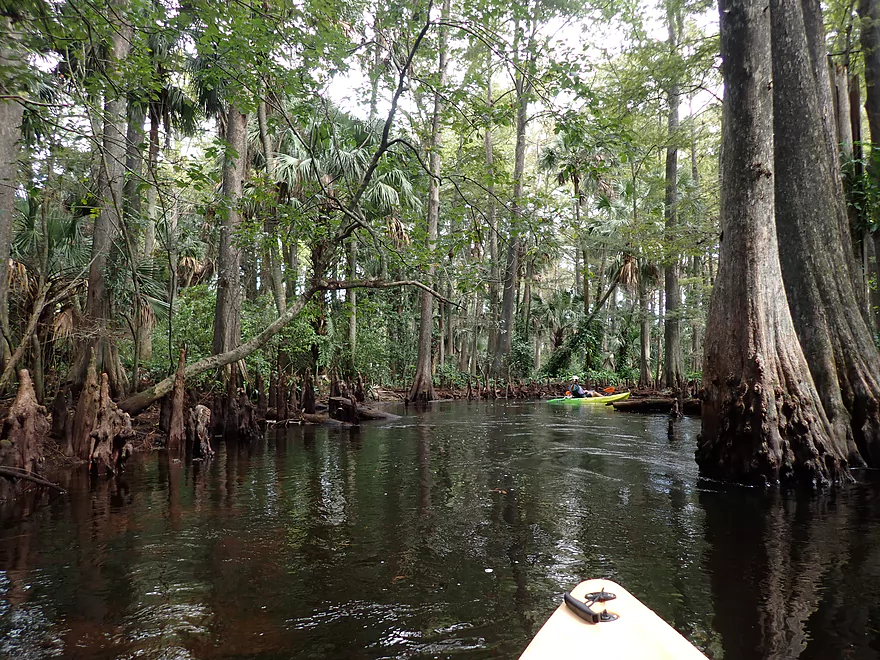
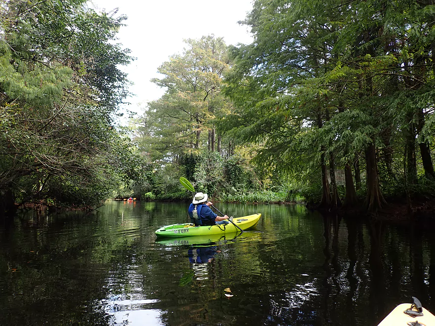
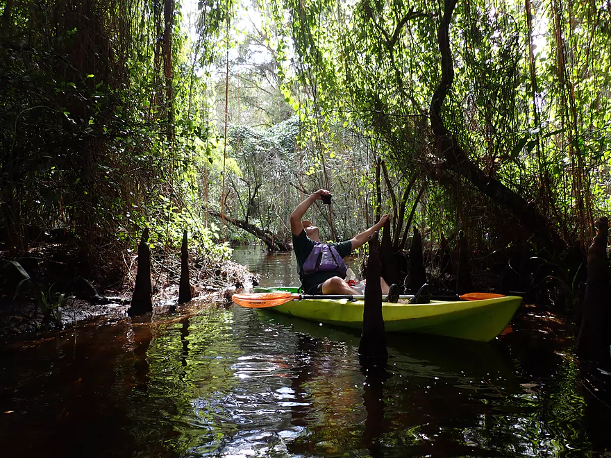
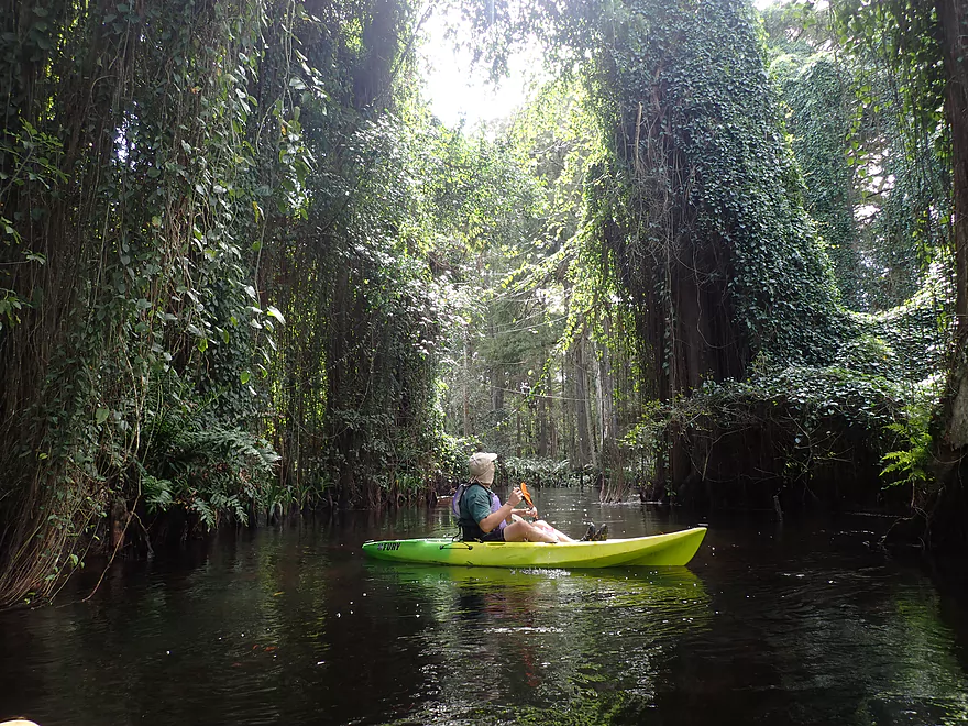
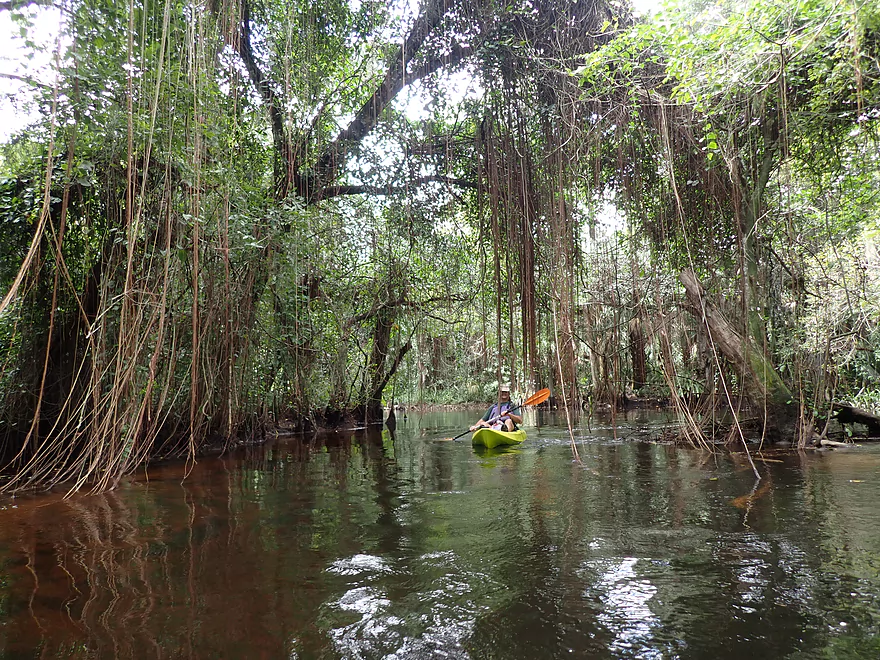
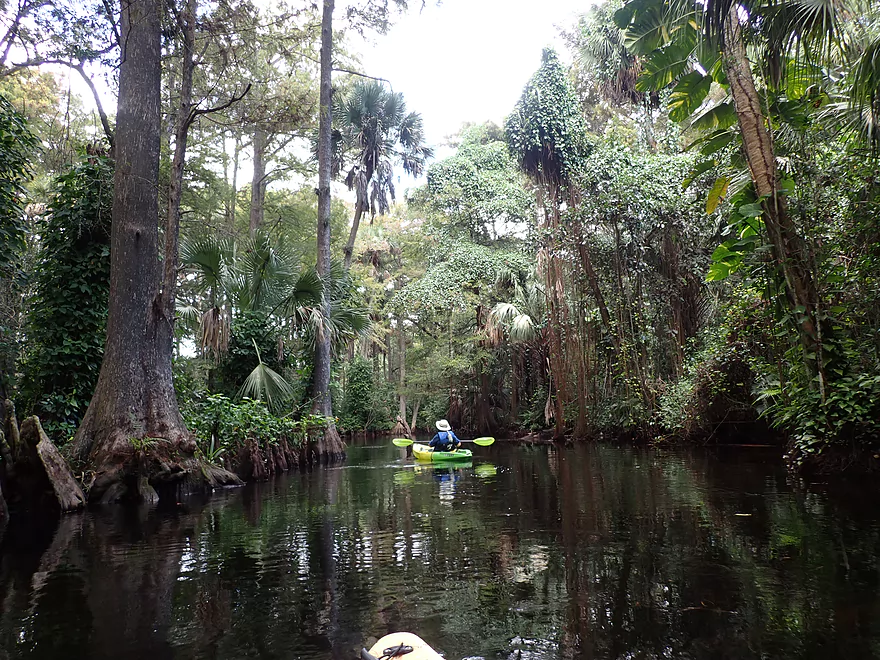
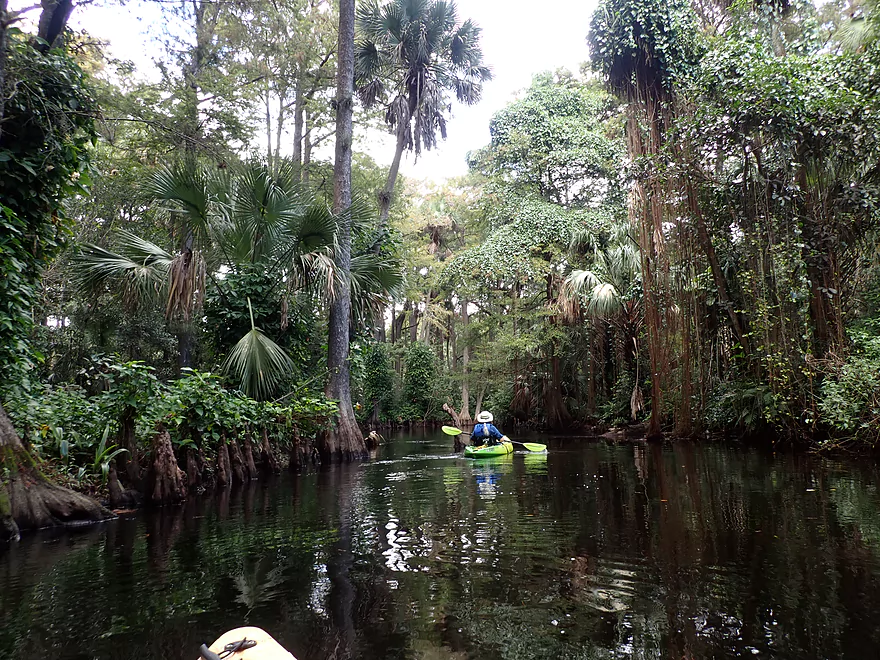
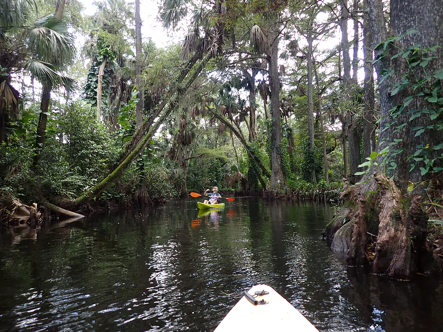
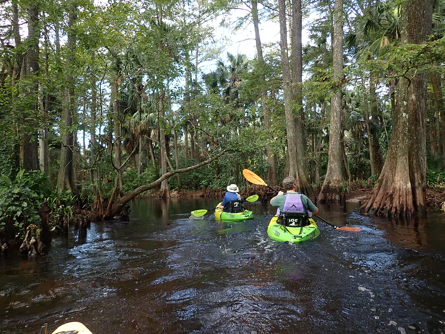
It felt like we were paddling through a jungle
Trees grew right up to the waterline
A palm growing the wrong direction
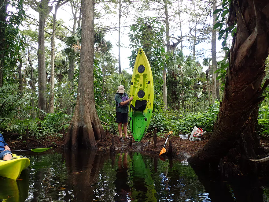
Stopping to empty a leaky boat
These might be strangler fig roots
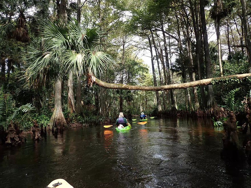
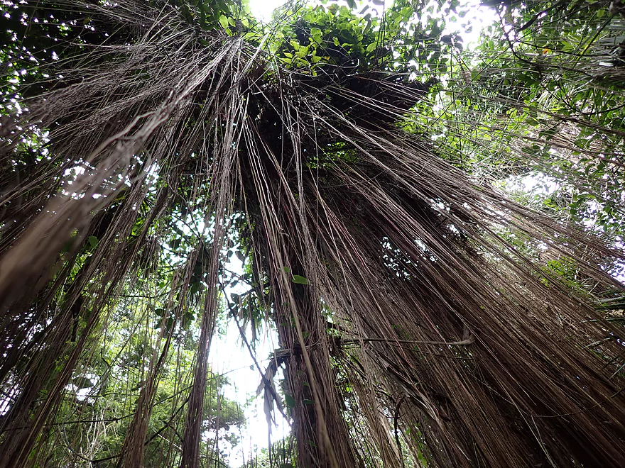
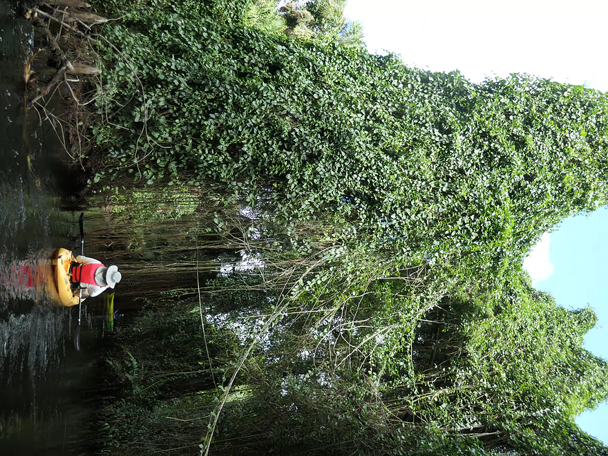
Vine canopy
More strangler fig roots
The river split into a couple of channels here
Paddling through the jungle
The river here was narrow and fast
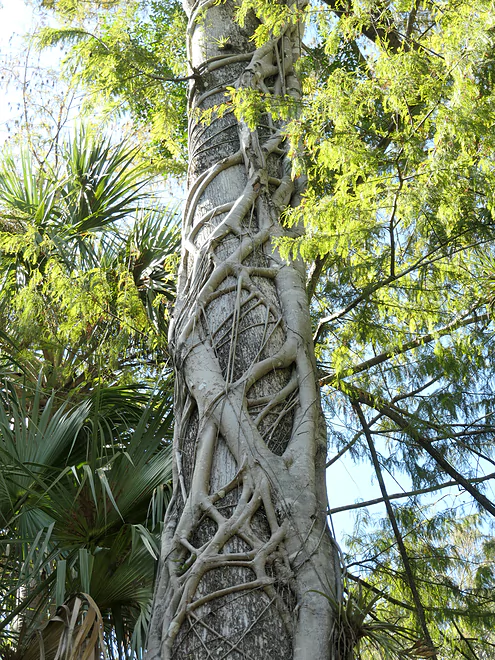
A great example of a strangler fig–eventually the host tree will die
No logjam portages on this trip
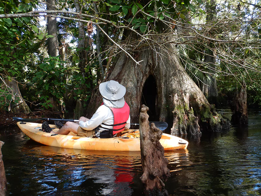
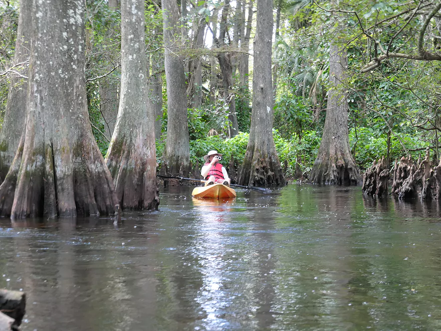
The cypress trees had very wide bottoms
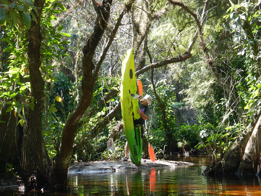
I think we had to bail this boat out three times
Water levels were a bit on the high side for this trip
Nice clear water
We turned around at the Masten Dam
Those wanting longer trips can continue downstream
Fighting the current to head back to the put-in
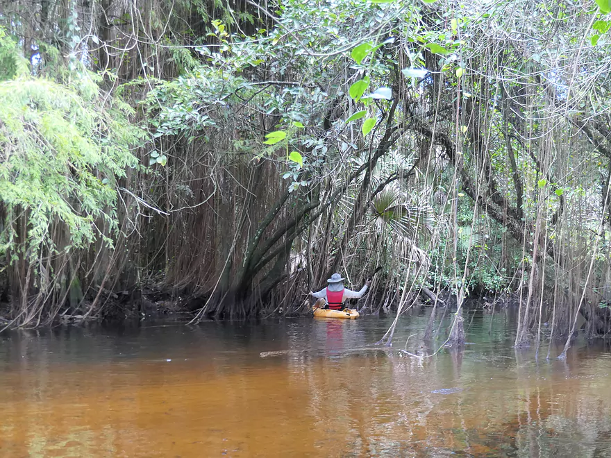
The cool vines again
One of the best tropical forest paddles in the Lower 48
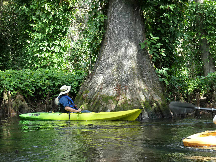
Some of the cypress trees were huge
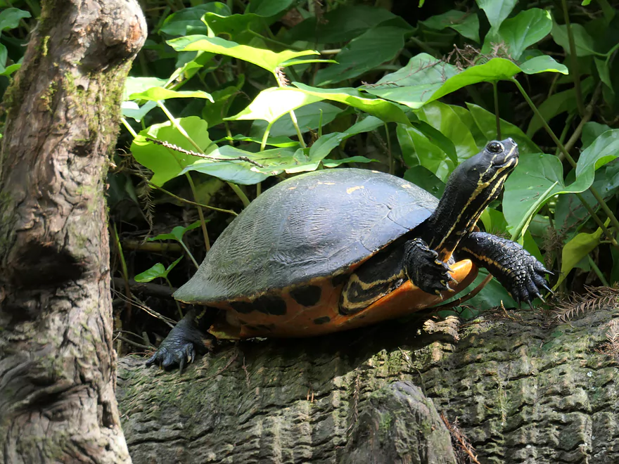
One happy turtle
Portaging the Lainhart Dam (pretty nifty–there’s a bench in the middle, too)
An osprey
Final leg
Taking out where we started
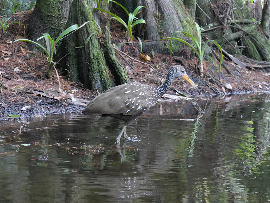
Where the same limpkin was still hunting snails
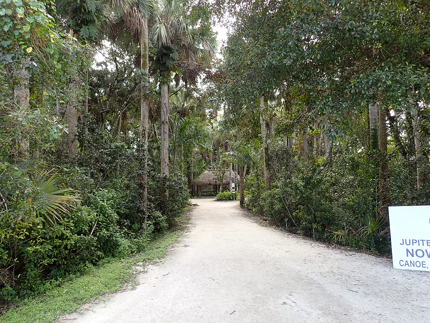
There is a neat trail system in the park that is also worth checking out
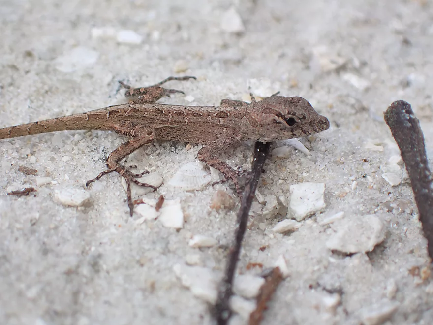
A lot of tiny lizards were scurrying about (this one’s a brown anole)
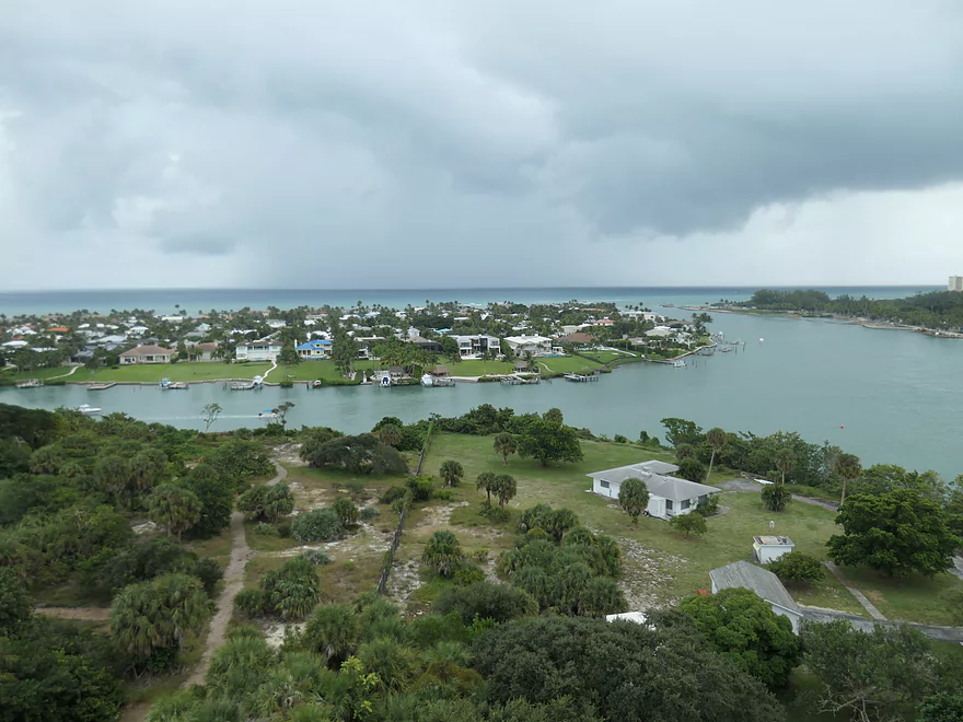
The mouth of the Loxahatchee seen from atop the Jupiter Lighthouse
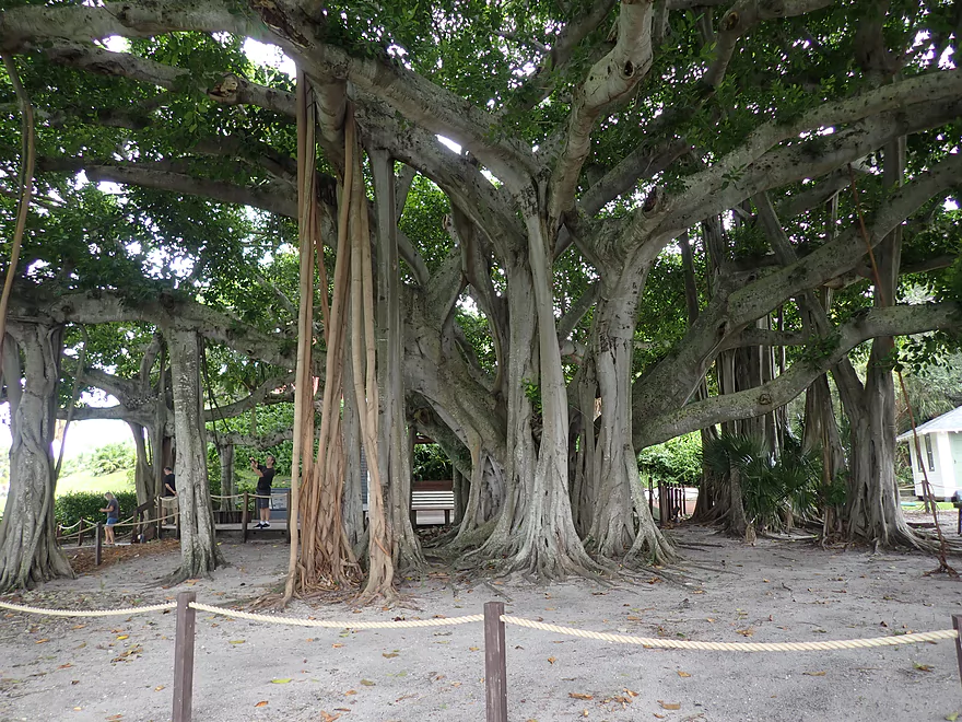
This fantastic banyan tree is located at the base of the lighthouse
Loxahatchee River

Typically this website just reviews water trails in Wisconsin (or close to the border). But I recently had a chance to paddle the Loxahatchee River in Florida. Given how popular Florida is with Wisconsin tourists, I thought I would provide a review for it.
Loxahacthee is a Seminole word meaning Turtle River (lowchow = turtle and hatchee = river). It’s a small river, but very scenic and is one of only two rivers in Florida to get the National Wild and Scenic River designation (in Wisconsin the St. Croix and Wolf Rivers have this federal classification).
The majority of the Loxahatchee watershed has been ruined by extensive development. The river is located by Jupiter which is at the far northern end of the vast Miami metro area (more people live in this metro area than in all of Wisconsin). Originally much of SE Florida consisted of swamps and marshes, but was drained via a huge network of drainage ditches and canals. The scope of these canals is staggering and you see them everywhere when you fly in. A significant portion of the upper Loxahatchee, whose headwaters are near the Everglades, is now nothing more than big ditchess. But close to the mouth, there is one final stretch that has been protected from development and still meanders naturally (mostly).
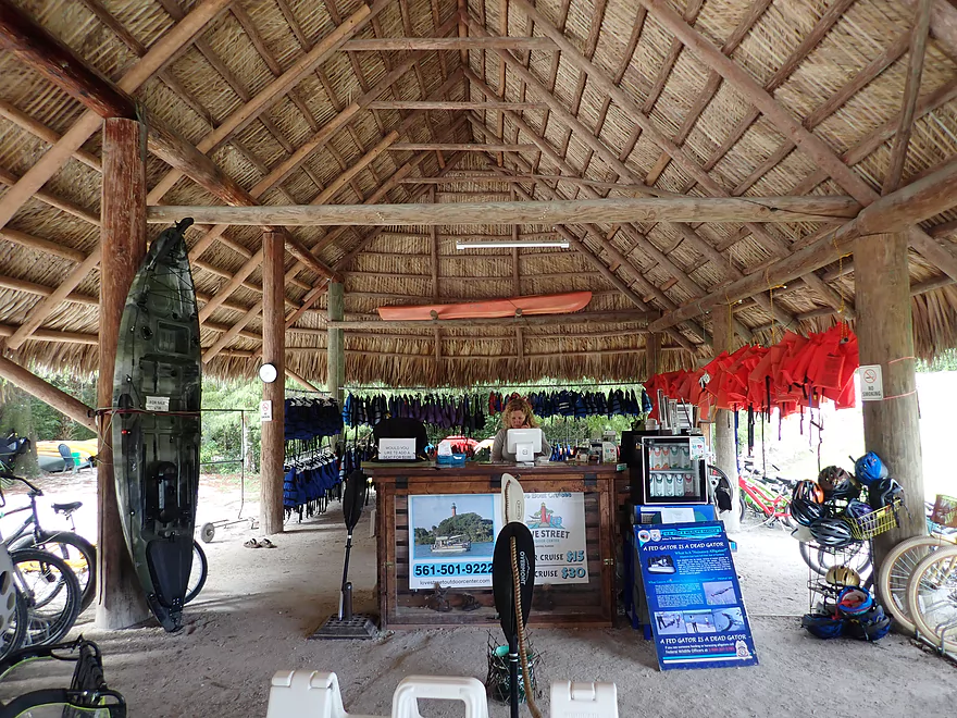
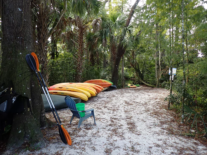
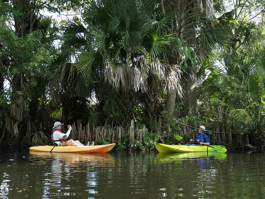
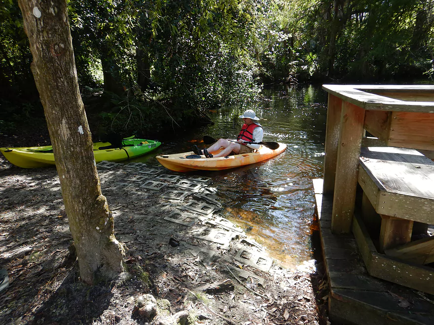
Most paddlers will start a trip in Riverbend Park where there are several launch options. We started by the Jupiter Outdoor Center (JOC) which is a private company located within the park and provided us with our kayak rentals.
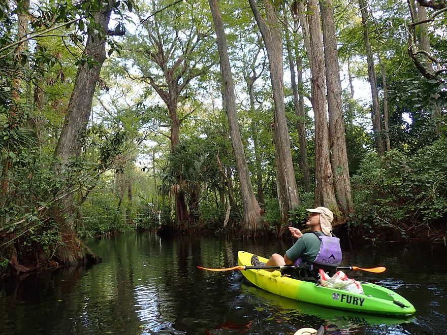
The put-in area by JOC was really cool. First it connects to the extensive Reese Trail network. This is a fantastic hike/bike trail that goes under a canopy of tropical trees and features little lizards scurrying about. By the river was a large Chickee where we paid for our boats (the Seminole version of a tike). These are large open-sided huts constructed with cypress logs and having a ceiling of woven together with palm thatch leaves. A nice sandy area surrounded by large tropical plants made for a great launch area.
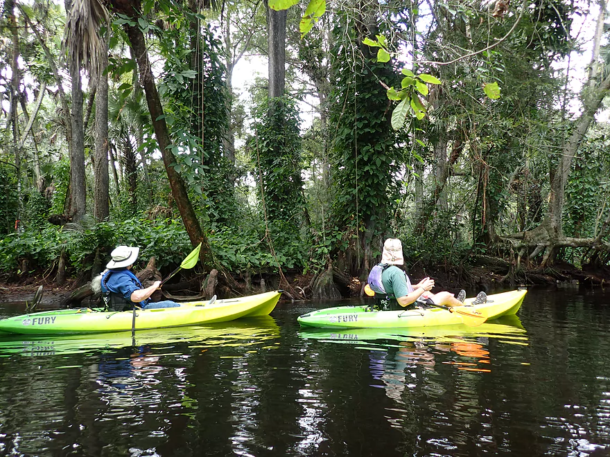
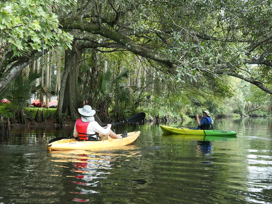
The first mile of the trip (JOC to the Lainhart Dam) appeared to be partially straightened and was fairly deep and slow. This stretch wasn’t the highlight of the trip, but the tea clear water, and large tropical plants growing on the shoreline were quite cool. Riverside logs were often lined with sunning turtles that seemed reluctant to dive (much tamer than Wisconsin turtles).
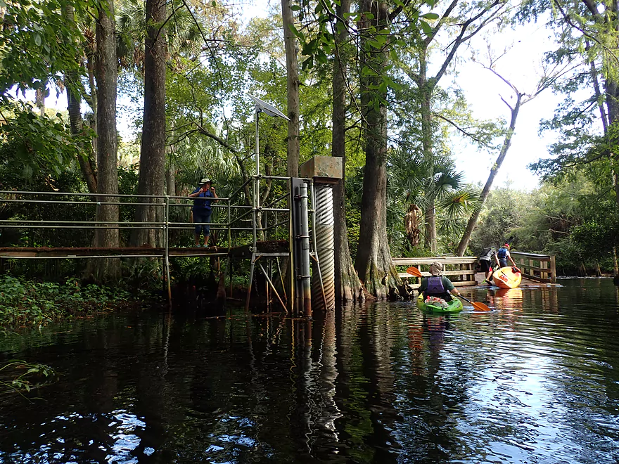
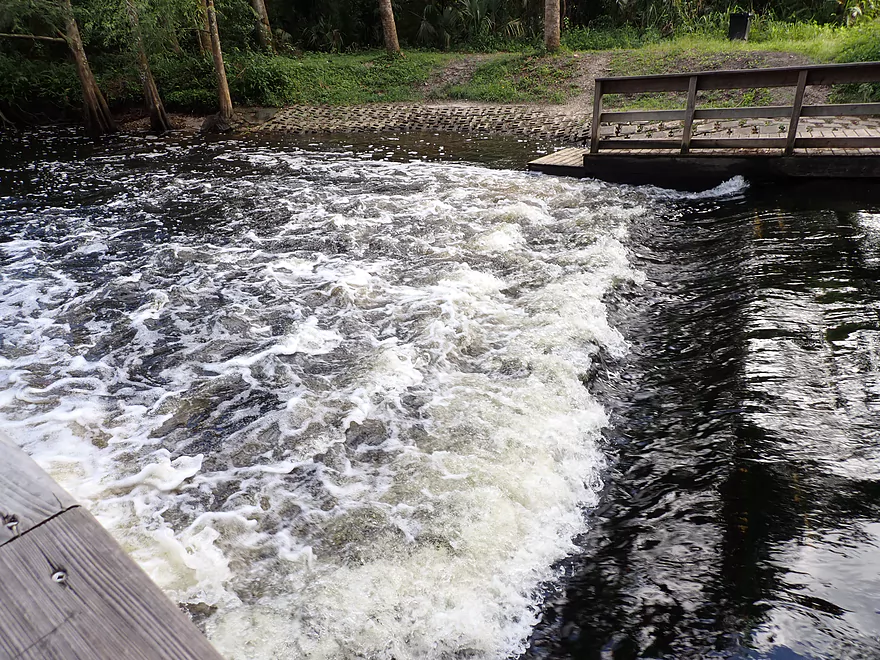
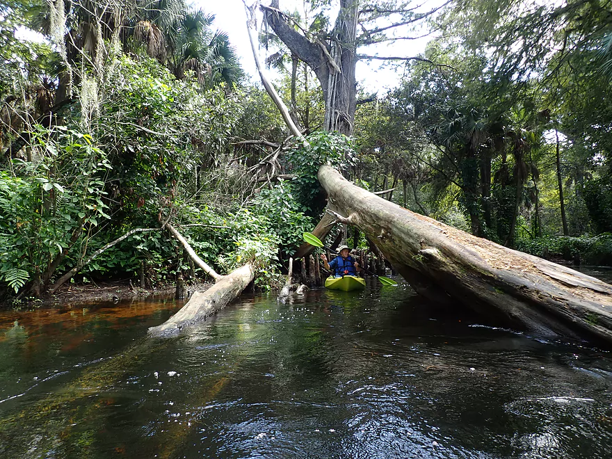
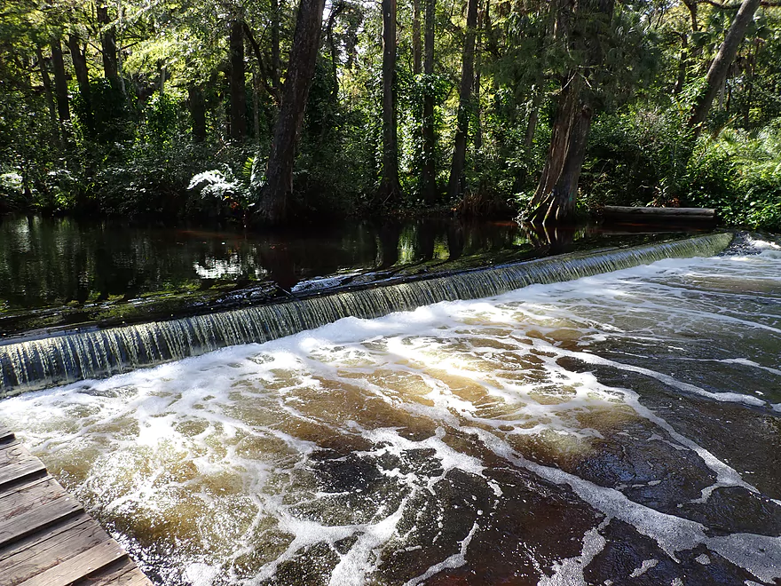
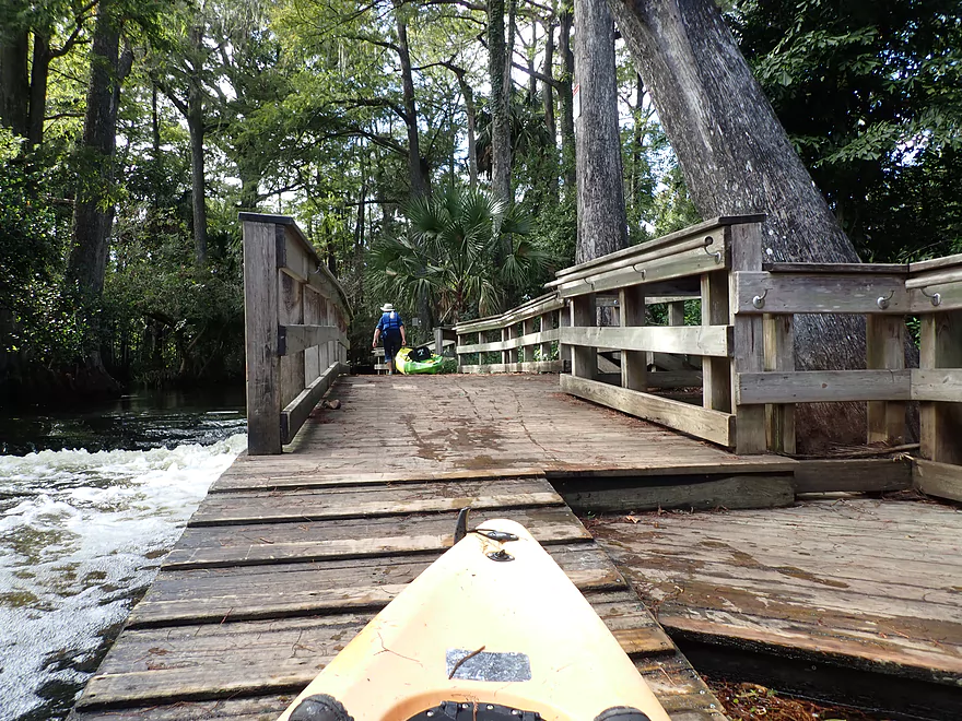
Then Lainhart dam was one of the major landmarks on the trip. It’s not very big and paddlers can even go over it (equivalent of Class 1 rapids). You can portage the dam if you wish and there is an excellent portage boardwalk on both sides of the river. I’ve portaged a lot of dams, but this has to be considered the best portage paths I’ve ever used. Wisconsin dam operators could learn from this example! Round-trip paddlers wanting an easy trip can turn around here (but I recommend you keep paddling).
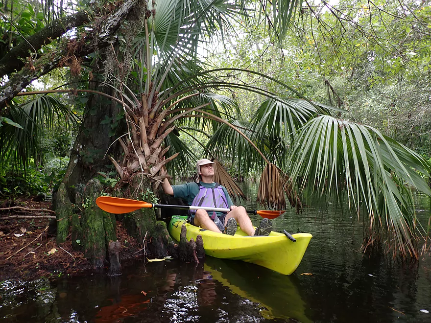
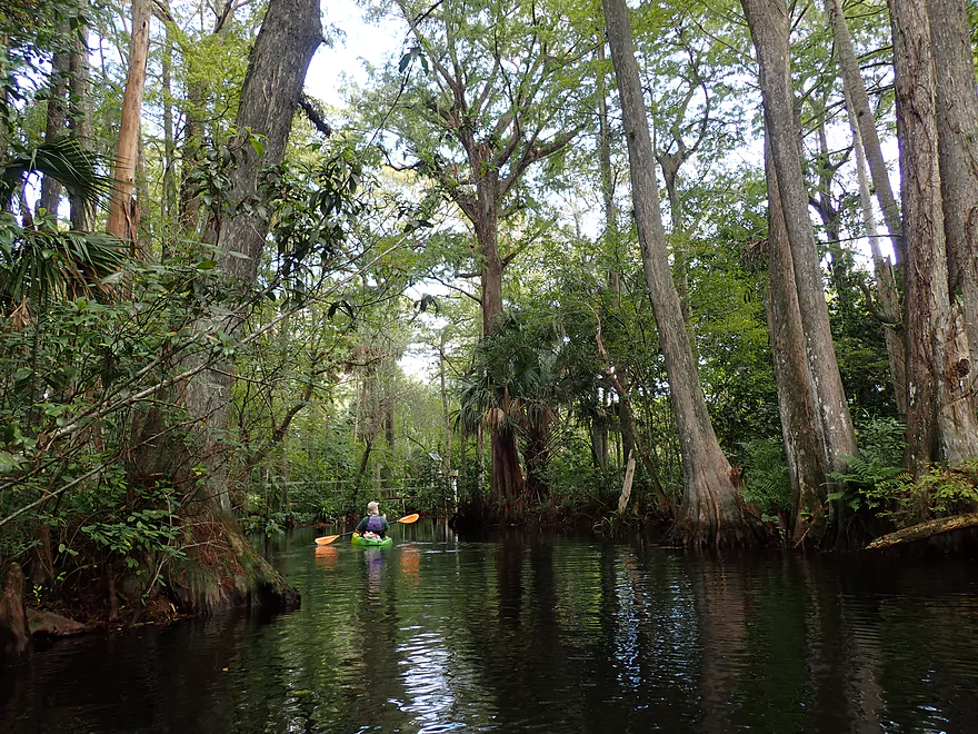
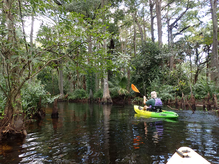
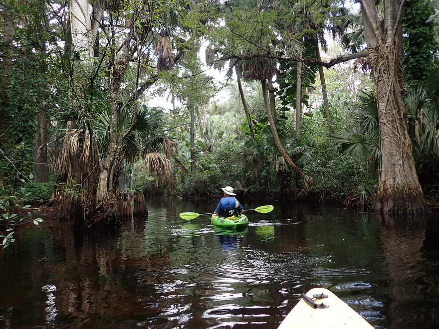
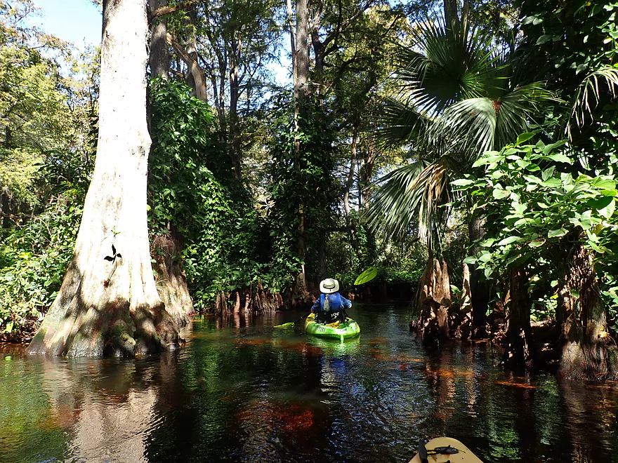
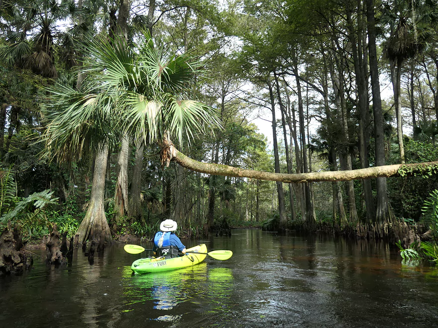
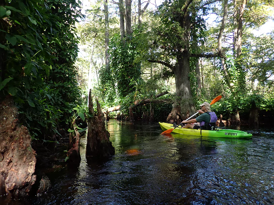
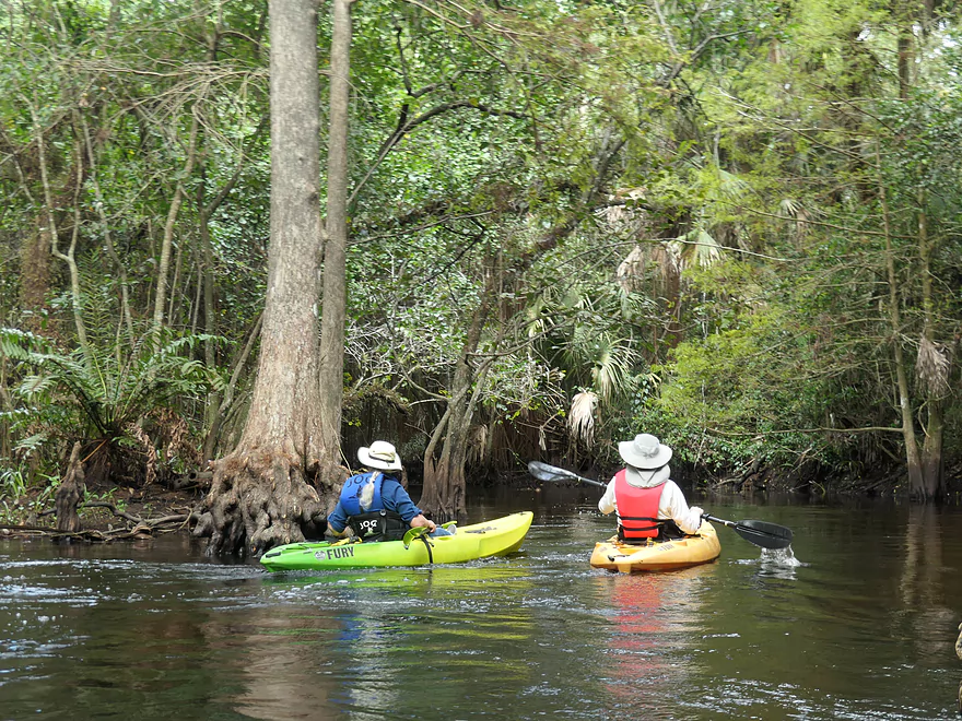
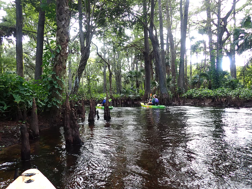
The next mile (Lainhart dam to the Masten Dam) was fantastic and among the best kayaking legs I’ve ever done. Here the current came to life and the river narrowed considerably. The channel flowed through a dense tropical forest and snaked under a scenic tree canopy with vines hanging from the branches. The mighty cypress tree was a common site and its wide bases would grow right up to and next to the channel, sometimes even redirecting the river. They had curious little “knees” that would occasionally poke up randomly from underwater (I think they allow the tree to breath). Giant leather ferns, palms, palmettos, and even the mighty banyan were a common sight along the banks. This is the closest IMO one can get to an Amazon-style kayak trip while remaining in the Lower 48 states.
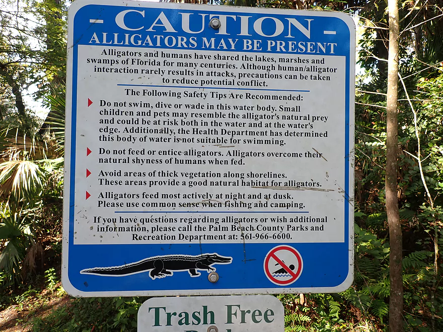
The Loxahatchee River can feature alligators and manatees, but unfortunately we saw neither. Maybe it was too early in the season for manatees? I did find another video online from a Loxahatachee paddler and they did have a cool manatee experience. Alligators are not uncommon on the river, and while we saw them at a couple of other preserves, we didn’t see them on the Loxahatchee. The rental attendant though did tell us that a small one swam by JOC just after we launched.
The Masten dam is about as far downstream as round-trippers go and it was here we turned around. This dam was a bit bigger than the Lainhart Dam and probably shouldn’t be run. It too had a fantastic boardwalk portage path and bench area which we used to take a break. A small canoe with a motor recently portaged this ahead of us (a trick with their outboard motor). They had come from downstream near Jonathan Dickinson State Park, which is kind of a no-no as motors aren’t allowed on this stretch of the river. We could have continued 6.3 more miles to JDS ourselves and that likely would have been a great trip, but that would have required a shuttle. The rental place did require advanced notice for shuttles so they can schedule a driver, so we settled for the shorter round-trip.
Padding back upstream was definitely trickier than going downstream and the current was a bit brisk in spots. You should be in shape if you attempt this. Some paddlers will give up and turn around before they get to the Masten dam, but the trade-off is they miss out on great scenery. In hindsight the best option IMO would have been to just continue 6 miles downstream to JDS…I suspect that would be easier than the one mile of upstream paddling we did. In our case we also had to deal with a leaky boat (which the rental place ” thought” had been fixed) and this required multiple stops to drain out. We ended the trip at JOC where we had initially started the trip.
In summary this was a fantastic trip I highly recommend for those visiting in the South Florida area. From the research I’ve done, the Loxahatchee is considered one of Florida’s best water trails for paddling, which is high praise as Florida has many nice rivers for kayaking. Maybe the only thing I would change if I were to redo this trip, would be to start earlier (Riverbend Park Canoe Launch) and take out later (Jonathan Dickinson State Park). Although I did feel we did experience the best part of the river.
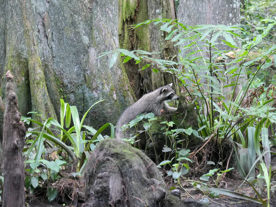
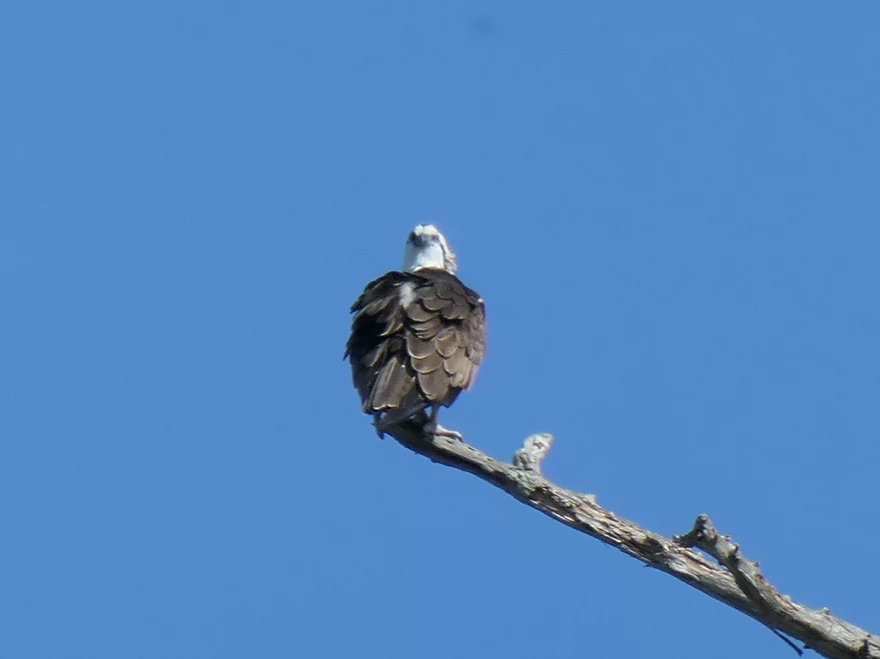
Sights included some large apple snails, a couple of tame limpkins eating those snails, an osprey, and several fish. Turtles were a common sight on this trip…these “Florida turtles” tended to be a bit bigger and have taller shells than common Wisconsin painted turtles (perhaps they are more bite resistant vs alligators). We did encounter a racoon who scurried up a tree to get a better view when he saw us. Little scurrying lizards (mostly anoles) are a common sight in south Florida…equivalent to squirrels in Wisconsin.
The Locahatchee can feature manatees and alligators, but we saw neither on this trip. Manatees migrate during the seasons to seek warm water, and I think we just had bad timing. We saw no alligators, but the rental attendant did say they saw a small gator float downstream by the put-in after we launched.
River Bend Park – Hiking Trails: Located just next to the river is a fantastic trail network worth checking out. Together these trails span over 10 miles and are bikeable (Jupiter Outdoor Center in the park rents bikes in addition to kayaks). These paths go through tropical forests where wildlife is common and you can enjoy occasional vistas of the river.
Jupiter Inlet Lighthouse & Museum: Where the Loxahatchee River meets the Atlantic Ocean there is a historical lighthouse. Visitors can climb to the top where there is a nice view. What’s actually more interesting is the massive banyan tree located at the base of the lighthouse. These are unique trees that start as aerial vines which kill their hosts. The vines will actually take root and grow into new trunks, spread the tree to ridiculous widths. The Great Banyan Tree in India covers 3.5 acres!
Beaches: Pretty much all of southeast Florida is one big beach. There are countless official beach locations to choose from (such as Jupiter Beach Park). These are all nice, and if in SE Florida you’ll want to visit at least one. In general though I don’t think the Atlantic beaches are as nice as the Gulf beaches. SE Florida gets pretty beat up by storms, and often lacks the sand dunes and seashells you’re more apt to see on the Gulf side.
Manatee Lagoon: Located south of Jupiter is a Manatee “Eco-Discovery Center”. Outside the building is a lagoon where manatees are known to hang out. Before you go, make sure to check their website to see if manatees are active. They are most likely to be in the area between November and March.
Giant Kapok Tree: If you’re in the Palm Beach area, definitely check it out….it’s ginormous. You can only see it from the South Lake Trail and is located west of Chapel Hill Rd and south of the Henry Morrison Flagler Museum. The roots of the tree rise up out of the ground like the tentacles of a surfacing sea monster.
Arthur R. Marshall Loxahatchee National Wildlife Refuge: This is located further south by Boynton Beach. The Cypress Swamp Boardwalk is fantastic…basically it’s a boardwalk through a dense and scenic cypress forest. Other highlights include a nearby butterfly garden and the Marsh Trail which was teaming with 2′ long iguanas. There was even a friendly alligator that swam toward us (we suspect locals feed the gators but you’re not supposed to).
Jupiter Outdoor Center (JOC): There is an access located at the north end of Riverbend Park which is a scenic and convenient access. “Jupiter Outdoor Center” has a rental station located conveniently nearby.
Alternative Access Points:
- Riverbend Park Canoe Launch: (0.6 miles upstream from JOC). If you’re not renting from Jupiter Outdoor Center, then you’ll likely want to launch here instead. This will add a half mile of scenic paddling to the trip. The launch is technically on an island and you could paddle completely around it if you wish.
- Jonathan Dickinson State Park: (7.7 miles downstream from JOC). There is a boat launch in the park which is a good access. For round-trippers this is located too far downstream and has too much current, so you’ll need to take out at the boat ramp and get a shuttle back. Typically the Masten dam is the point of no return where paddlers need to decide if they will end their round-trip or continue on as part of a one-way trip. The stretch from the Masten dam to Trapper Nelson’s is supposedly very good and scenic. From Trapper Nelson’s to JDS though the river widens considerably and becomes more brackish. I suspect that isn’t as interesting.
Round-Trips: Most paddlers simply do round trips which are “mostly” viable. The easiest route is Riverbend Park to the Lainhart Dam which has little current. A longer but also popular route is Riverbend Park to the Masten Dam. Between the two dams is the best scenery on the river, but it requires backtracking against at times strong current (depends on water levels too). It’s doable, but you should be in shape or be in a tandem with somebody else who is.
Bike Shuttles: The ideal trip is from Riverbend Park to Jonathan Dickinson State Park, but that requires some type of shuttle. If in Wisconsin I would readily suggest a bike shuttle, but southeast Florida is not so bike friendly. There are toll-roads, gated communities, endless cul-de-sac mazes, and inhospitable freeways to deal with. JDS to JOC is in theory a 7 mile shuttle, but you would have to sneak on the Hwy 706 freeway and past its cloverleaf which Google doesn’t recommend and is likely not legal.
Rideshare/Taxi: Jupiter is at the far northern end of the Miami/West Palm Beach metro area so Lyft and Uber options should be plentiful. Note, crime is a bit higher in Florida, so when you lock your gear/boat to do the shuttle, make sure you have a good lock and/or hiding spot.
Rentals/Liveries: There are several businesses that service the Loxahatchee River.
- Jupiter Outdoor Center – 561-747-0063. This is I believe the most popular rental option and what we chose. Rates vary based on the type of boat (kayak/canoe/tandem) and the time on the water. I believe we paid $50 per person for 4 hours. This business also provides shuttles to JDS, but you do need to call ahead of time to make sure a driver will be available.
- Jonathan Dickinson State Park Concessionaire – 561-746-1466: Kayak rentals are available, but I don’t think the park offers shuttles. I’m not sure this is a good option as JDS is located further downstream on the river away from IMO the best parts of the Loxahatchee.
- Jupiter Beach Watersports – 561-745-6900: While they service the Loxahatchee, they mostly do so by the Atlantic Ocean where IMO the river isn’t as interesting. I’m not sure they go as far west as River Bend.
Logjams: From Riverbend Park to the Masten Dam there really aren’t any. There is one downed tree, but that was easy to duck under. If you do the longer trip (Masten Dam to Trapper Nelson’s) there reportedly are some downed trees that paddlers need to portage or hop over, but they don’t sound too bad.
River Current: From Riverbend to the Lainhart Dam there is little current and round-trips are easy. From the Lainhart Dam to the Masten Dam there is occasionally decent current, which can make round-trips more strenuous. Many paddlers consider this an acceptable trade-off because that leg is so scenic. But you should be in shape and prepared for a workout to get back to the Lainhart dam.
Tidal Current: Upstream of the Masten dam this shouldn’t be an issue. For those doing longer trips, tidal currents and levels can be more of a factor downstream from Trapper Nelson’s. Levels can change up to 2′ depending on the tide and tidal currents can be strong.
Dams:
- Lainhart Dam: This is located a half mile downstream from JOC and is an easy portage. You can run the dam when there is enough water.
- Masten Dam: This ledge can almost be run, but likely shouldn’t as there is recirculating current at the base. There is an excellent portage path/boardwalk adjacent to the dam.
Getting Lost: There are several side channels/canals. When heading downstream these are easy to avoid…just go with the current. But when returning, you should be careful about not heading up to Peacock Lake by mistake. We saw one kayaker do this, but she quickly realized her mistake and turned around. As long as you study a map, getting lost shouldn’t be an issue.
Alligators: Most Wisconsin paddlers will be leery of paddling with alligators, but people in Florida do it all the time. Alligators are less aggressive than crocodiles and tend to be shy around large objects (like kayaks or large adults). However, I would be lying if I said the chance of an alligator fatally killing a paddler was 0%. Florida averages maybe a fatal alligator attack once every year or two. A noteworthy attack occurred in June 1993 on the Loxahatchee River just downstream from the Masten Dam. A family was portaging their canoe around a downed tree. Their 10-year old wandered off and waded knee deep into the river. He was then fatally attacked by a large gator. Even if you stay in your boat, there is some risk of an attack. Just last year a North Carolina paddler filmed a viral video where he was attacked while paddling. He was able to fend it off and continue on.
Again, your chances of being attacked are quite low. There are many common sense safety measures you can take.
- Alligators are most aggressive in the summer when they are mating. Winter might be a better time for paddling.
- Alligators are most active at dusk. Morning paddles might be best.
- They are protective around their nests. Avoid these mounds if you see them.
- Signs warn not to bring pets or small children on the Loxahatchee which is a good idea.
- Signs also warn not to wade, which is also a good idea.
- Alligators are ambush predictors. They prefer to sit still in areas sheltered from river current and by brush so they can hide.
- Bigger kayaks are more likely to deter attacks (the North Carolina paddler was in a very short boat).
- Don’t corner a gator with your boat.
- Consider bringing an airhorn.
- Ask the rental attendant about recent alligator activity.
Snakes: Florida has many poisonous snakes. We didn’t see any on this trip, but at a nearby nature park we did see a water moccasin. Fatal snake attacks in Florida are pretty rare (much more rare than gator attacks), but you do want to be careful, especially if you get out to portage any downed trees. South Florida also suffers invasive giant pythons that are capable of swallowing adult humans. Python attacks in Florida are extraordinarily rare, but a fatal incident did happen near Orlando in 2017.
There is a nearby gauge located by the Lainhart Dam. We did the trip at 175 CFS. The following is a rough guestimate for water levels. Higher levels in general mean stronger current and will make doing round-trips more difficult.
- 0-50 CFS: A very low depth. You may need to drag your boat over downed trees.
- 51-100 CFS: A low depth.
- 101-200 CFS: An average depth.
- 201-300 CFS: Above average depth.
- 301-400 CFS: A high depth. Round-trips past the Lainhart dam may become quite difficult because of the strong current.
- 401+ CFS: A very high depth.
- Upstream on the Hungryland Slough Canal: I’m not really sure the canal is navigable. There are several gates and dams to deal with. Plus I’m not sure it’s that interesting.
- Hungryland Slough Canal to Riverbend Park Canoe Launch: 1.4 miles. This might be a round-trip only option as the south end of the river has a dam that may not be easy to portage. This stretch should be an ok paddle, but it is artificially straightened/deepened, so may not be as interesting.
- Riverbend Park Canoe Launch to Jupiter Outdoor Center: 0.6 miles. This is a nice stretch for paddling. You can paddle completely around Picnic Island.
- Jupiter Outdoor Center to Masten Dam: 1.4 miles.
- Jupiter Outdoor Center to Lainhart Dam: 0.5 miles. This is a good stretch with little current and is good for round trips.
- Lainhart Dam to Masten Dam: 0.9 miles. This is likely the best leg on the river and is fantastic. Here the river is narrow and sheltered by large tropical trees. There is some current which will require effort for round-trippers, but it is worth it.
- Masten Dam to Trapper Nelson Interpretative Site: 2.4 miles. This is likely the second best leg on the entire river. There may be some low trees on this stretch that have to be portaged. Unless you are uber athletic, going past the Masten Dam will be too much for round-trippers and you’ll want to continue to JDS only as a one-way trip.
- Trapper Nelson Interpretive Site to Jonathan Dickinson State Park: 3.9 miles. River widens significantly with the addition of Cypress Creek. This part of the river likely isn’t as interesting and may be influenced by the tides.
- Jonathan Dickinson State Park to Sawfish Bay Park: 5.1 miles. The river here is very wide (almost a lake) and the shorelines are heavily developed. Motor boat traffic may be common here. I doubt this stretch is good for kayaking.
- Sawfish Bay Park to Jupiter Beach Park: 1.3 miles. This is the last stretch of the river. Here you can see the Intracoastal Waterway, the Jupiter Lighthouse and the Atlantic Ocean.
This will be my last review for the 2021 season. Thanks to everybody who followed the blog and a special thanks to all the guest reviews (10 total for 2021!). Readers are always welcome to submit their reviews using my online form. The following is a recap of the ups and downs of the 2021 season.
My first trip of the season on the Kickapoo was fantastic. I’ve always wanted to do an “ice flow” paddle and this turned out to be a really “cool” experience. Next week was a disappointment on Rocky Run Creek (I miscalculated the logjam situation) but the week after was a positive experience on Taylor Creek (a prospect I really wanted to do in 2020). Chapman Creek was ok, but most of what I remember was the bitterly cold bike shuttle. I’m not a cold weather paddler, and I may do fewer of these in the future.
Next up was the Pine, which included not only the classic Rockbridge stretch, but also a bonus upstream leg that few explore. The Little Grant was a terrific find that almost nobody paddles. This was a river I found only after extensive map research. Outside of a few logjams, the Sudan Branch of the Pecatonica was surprisingly nice, but my memory was marred by the cold weather and light rain. In general, I shouldn’t complain about the weather too much in 2021, as it was surprisingly good for many weekends and Wisconsin had perhaps the least amount of flooding since 2015.
Westfield Creek was another fantastic find and I’m excited about exploring more of the Montello River in the future. The Maunesha was a terrific experience and it was great to finally redo this trip after my previous paddle faced so much adversity. The West Branch of the White River was my other (besides Westfield Creek) big spring discovery. That was fantastic with nearly perfect water clarity. One of my 2022 goals will be to paddle more of this branch.
Both my Grand River and Upper Pecatonica trips were water trails I don’t think will ever become popular with paddlers, but I was pleasantly surprised with both. The Rubicon was a mixed experienced with a blah experience, but the river was fantastic below the dam. I am interested in paddling more of the Rubicon but need to plan carefully around its many logjams.
Finally at the end of May I was able to return to west central Wisconsin, starting with Arnold Creek which isn’t in the same caliber as other Black River streams, but was still nice. The Big Eau Pleine (like other sections on the river) was great (despite having my bike lock jamming at a most inopportune time), and the Greenwood stretch of the Black was a lot of fun.
One of my goals for 2021 was to redo some of my more outdated trips. This included the Lower Dells which was a great experience and featured more caves than I previously remembered. The Lower Bark has been on my todo list for many years and it was a great trip to finally do. The Mullet River was a solid trip, but most of what I remember unfortunately was being slightly sick during that day and the long drive. I live in the Wisconsin Dells area and usually prefer to do trips within a two hour driving radius which covers almost all of southern and central Wisconsin.
The Rock River, East Branch by Theresa was IMO one of my great water trail discoveries of the summer and I really liked that trip. The Buffalo River was a great trip with terrific Mississippi bluffs…but it was one of my less popular reviews in terms of views. I’m not sure why. The Kickapoo (bridge 4-7) was a redo, but was one of the best paddles of the summer.
One of the more memorable trips was the Wisconsin River by Port Edwards. In some ways I messed up with my timing because the boulder gardens I hoped to photo were under water…but on the flip side I got to paddle some original Wisconsin River rapids which was only possible because of a temporary dam drawdown. I also purchased a new kayak (another Wilderness Tsunami 125) at this time, but was a bit disappointed that it was heavier/larger than my old boat and I may try to sell it and keep trying to keep my old red boat working as long as possible.
This was followed by a pair of classic southern Wisconsin water trails in Turtle Creek near Tiffany and the Grant River by Grant River Rd.
The Wisconsin River – Plank Hill trip was a unique experience with fantastic sandbanks. Marsh Creek was a neat paddle…but it really needs some of its logjams cleared out. Fish Lake was among the most unique experiences and featured paddling around flooded trees and homes. At around this time, I had planned a big trip to the St. Croix but had to cancel at the last minute. It was unfortunate I didn’t get up north (central Wisconsin doesn’t count) in 2021, but it was nice to have some guest reviews fill the gap.
The Lower Oconomowoc and Lower Pecatonica were ok trips, but nothing special. Given the nice weather then, I regret not doing something more exotic in that time frame. Wildcat Creek was another pleasant discovery but did suffer from shallow water.
One of my favorite times to paddle is in October. It’s not hot/humid, you get good fall color, sunlight is less harsh, and the skies are a richer/darker blue (less haze in the sky because of colder temperatures). My first October trip was the Upper Little Wolf which was fantastic. Typically I don’t like to do two similar river reviews in a row (which can be confusing for readers), but I knew I had to this time because the Little Falls stretch looked so good. That second Little Wolf trip was one of the best paddles of the year.
The Lower Yahara was a trip I’ve wanted to do forever and that turned out surprisingly nice. The Lower Sheboygan was one of the best paddles of the year. By the time I got to Mill Creek, most of the color in the state was gone…so that was mostly a “B paddle” but was still nice with good driftless scenery. The season ended with the Loxahatchee which turned out to be among the best paddles I’ve ever done. Wisconsin is very fortunate to have so many great water trails, but it’s always nice to get out of the state every now and then.
I’m definitely looking forward to the 2022 season. For many rivers, I’ve used up the “low-hanging fruit”, so I’ll have to be more creative in finding new water trails, but they are definitely out there. My 2022 todo list definitely includes some new ideas that will surprise readers. See you next year.
Trip Map
Overview Map
Video
Photos Size: